About Helen
As an artist, I focus attention on places that are often overlooked or inaccessible, capturing the remarkable variety of ways that wind and water shape the landscape. My photographs and photo-based sculptures take you on a journey through these spaces and illuminate the interacting forces affecting environments and ecosystems, including human activity, from the remote polar environments of Antarctica … more
Walking in Antarctica: Antarctica in 3D - Sculptures and Source Photos
-
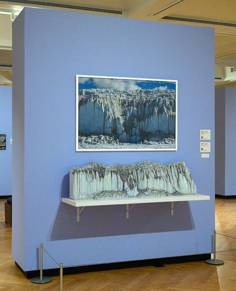
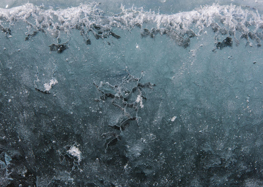
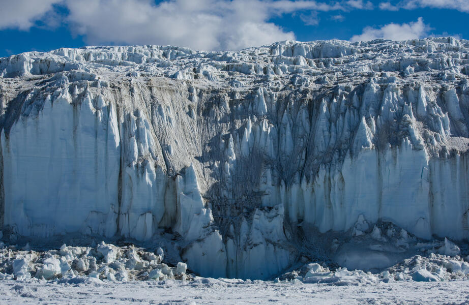 Canada Glacier from Lake Fryxell, AntarcticaCanada Glacier from Lake Fryxell, Antarctica (2015), archival pigment print, 32.5 x 50 inches. Section of the Canada Glacier captured in the 3D file. A section of the massive, spired 60-foot-high side of the Canada Glacier photographed from the frozen surface of Lake Fryxell. The journey here entailed crossing the melted margin in a rowboat used by lake scientists and a bumpy ride over the ice on an ATV.
 -
 2024-0504-8.jpg
Installation of the Canada Glacier from Lake Fryxell sculpture on view at the Juliet Art Museum, Clay Center, Charleston, West Virginia, in 2024 as part of Walking in Antarctica.
-
 CanadaGlacier-2015-12-19_Panorama.jpg
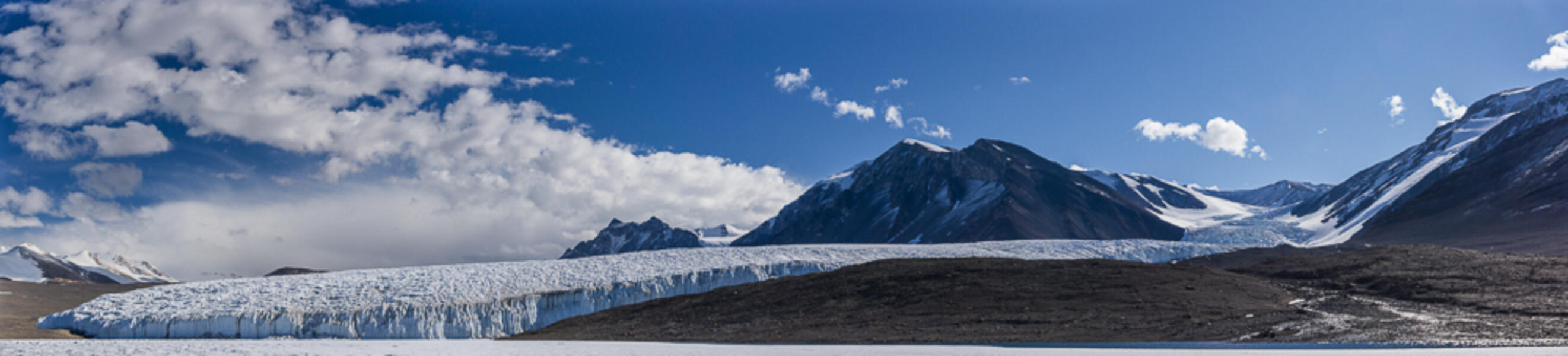
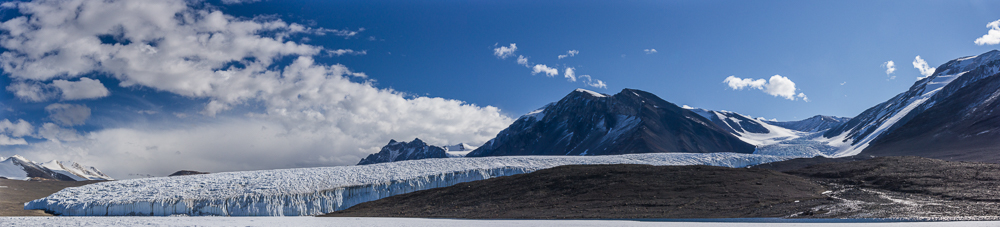
Panorama of Canada Glacier from Lake Fryxell, Antarctica (2015) photograph, 16.5 x 73 inches. The panorama gives some perspective on the size of the glacier. The area I photographed to make the 3D scan for the sculpture is on the left, centered in the area adjoining the lake.
-
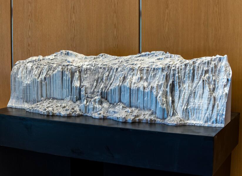
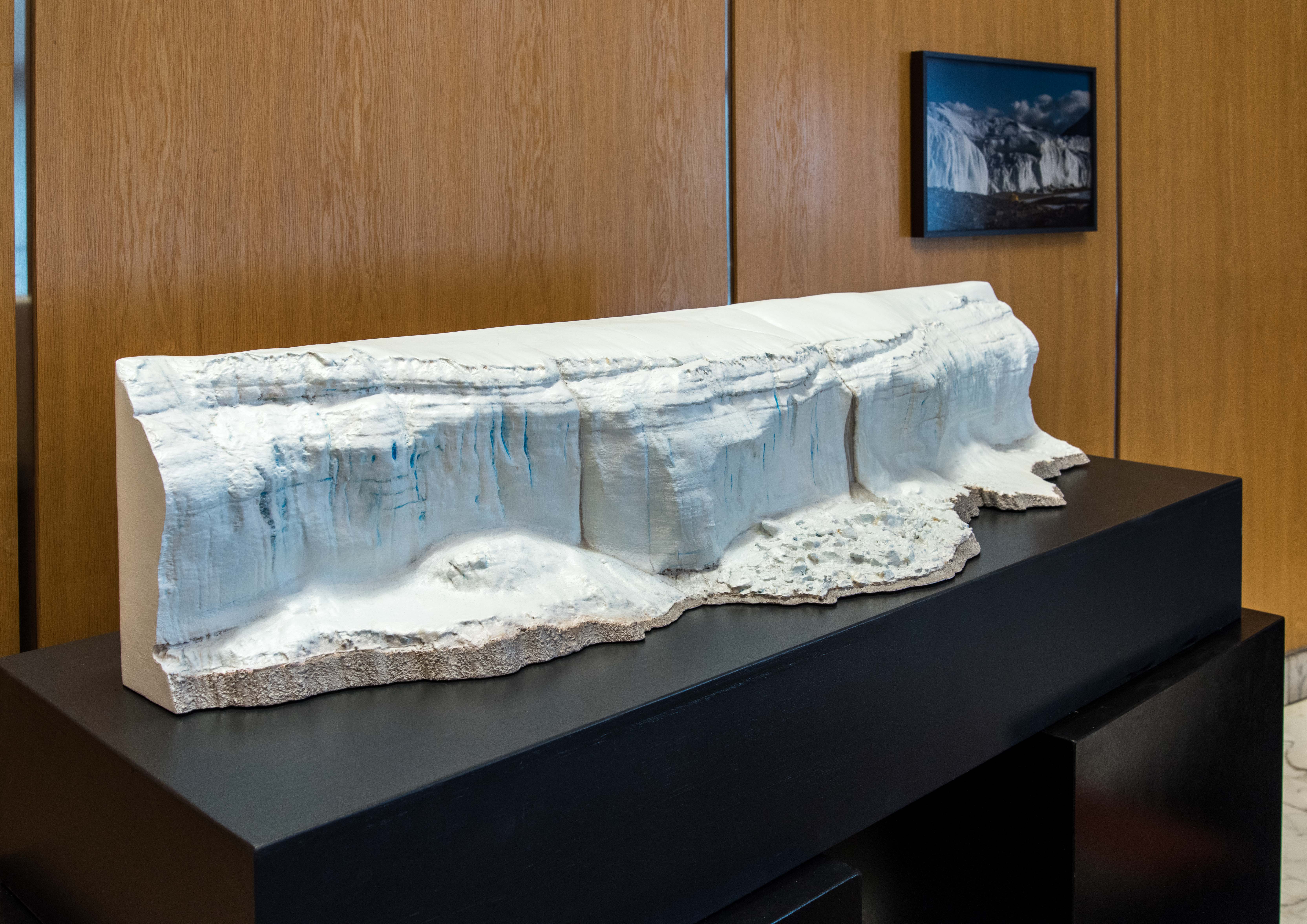
 Canada Glacier from Lake Hoare, AntarcticaCanada Glacier from Lake Hoare, Antarctica (2017) acrylic on 3D-printed PLA plastic, 11 x 54 x 15.5 inches. Sculpture of the west-facing side of the Canada Glacier. The basic 3D scan was generated via photogrammetry from still photographs and further edited. I printed it in sections, epoxied them together and painted it in acrylics.
 -
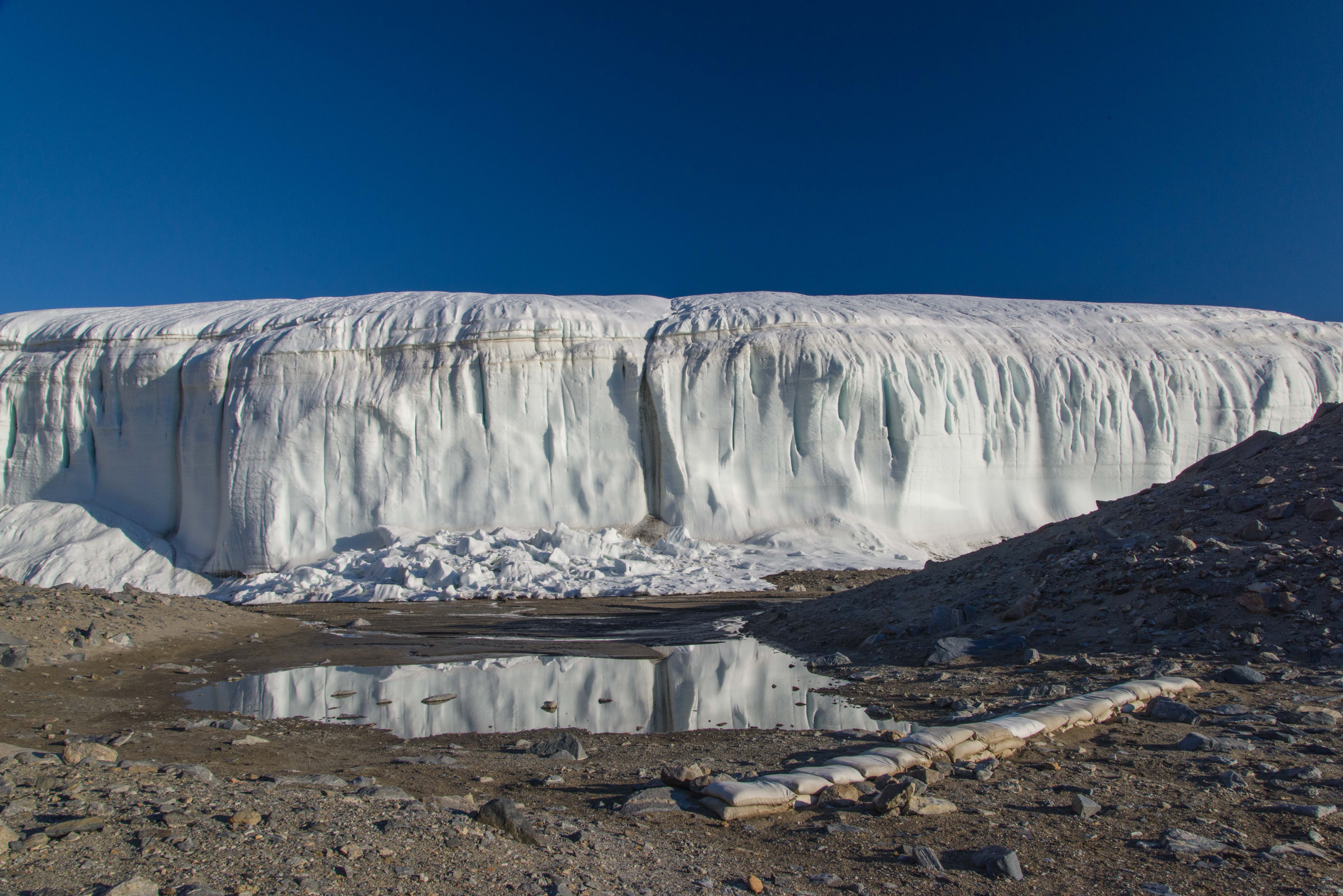
 Canada Glacier from Lake Hoare, AntarcticaCanada Glacier from Lake Hoare, Antarctica (2015) archival pigment print, 26.5 x 40 inches. The west facing side of the Canada Glacier rests alongside the Lake Hoare field camp. A row of sandbags has been placed at the edge of the area where meltwater flows in a stream during the austral summer.
 -
 2024-0201 Fairfield-2-3.jpg
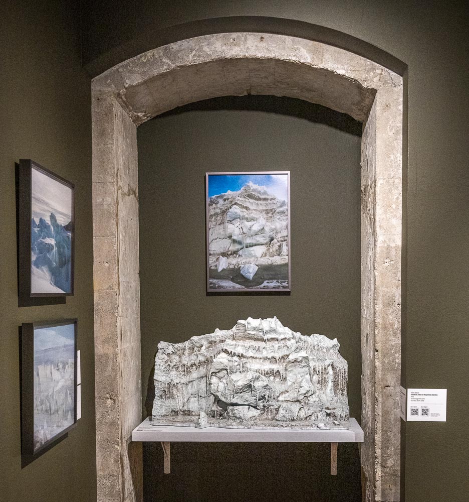
Giant's Face" Pressure Ridge, McMurdo Sound, Antarctica (2017) acrylic, oil and wax on 3D-printed PLA plastic and polymer-modified gypsum, 19.5 x 36 x 15.5 inches, with one of the source photographs above it, 22 x 15.675 inches. Sculpture of a 20-foot-high Baroque looking sea ice pressure ridge in a remote section of New Harbor. The basic 3D scan was generated via photogrammetry, further edited, printed in sections and epoxied together. I added the icicles by hand and then painted it. This photo is from the installation of Walking in Antarctica at the Fairfield University Art Museum in 2024.
-
 2024-0304 Fairfield-5-2.jpg
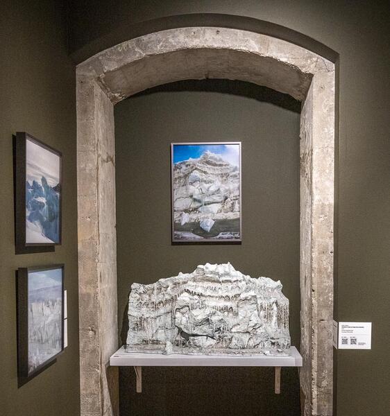
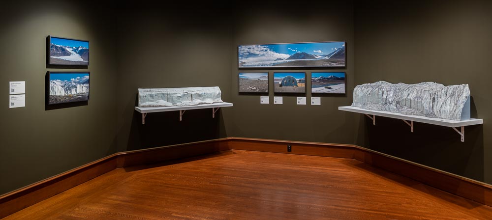
This alcove of the Fairfield University Art Museum's 2024 installation of Walking in Antarctica includes photographs and sculptures from the section of the exhibition titled "A Walk Over the Canada Glacier."


Walking in Antarctica: Sea Ice Formations
-
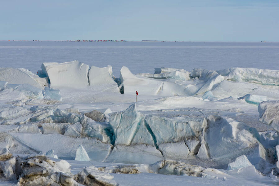
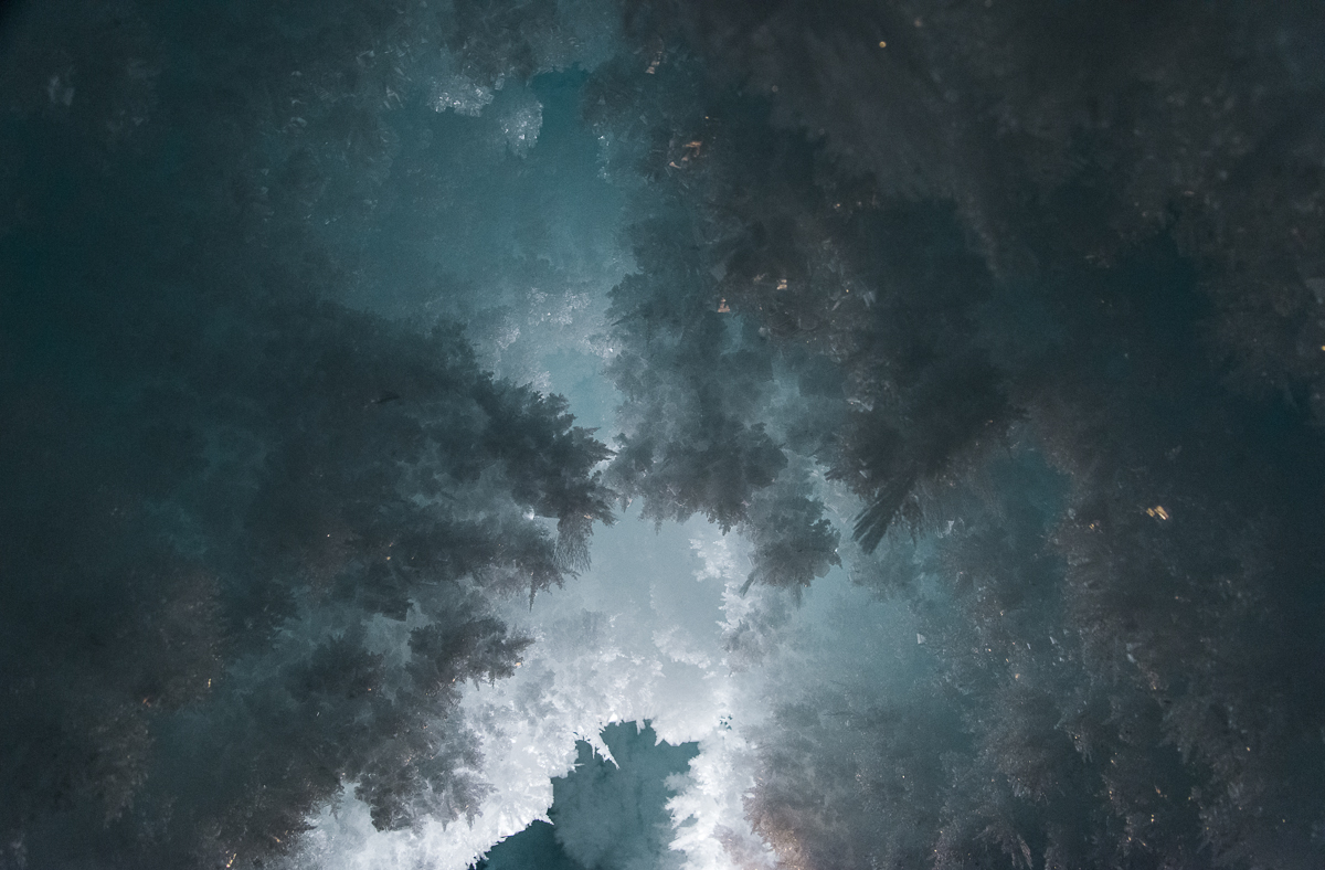
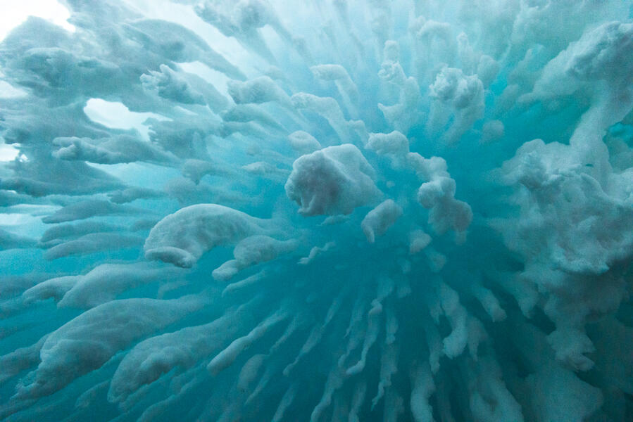 Cloudburst, Erebus Ice Tongue Cave, AntarcticaCloudburst, Erebus Ice Tongue Cave, Antarctica (2015), archival pigment print, 26.75 x 40 inches. Crystals hang from an interior ceiling just inside the cave entrance. The Erebus ice tongue is the end of a glacier that extends onto the sea ice on McMurdo Sound. A small opening in the tongue leads to an ice cave containing unusual and fragile ice crystal structures. It is accessible only a few weeks a year. Further inside, it is pitch dark, but just inside the opening, the ceiling had a blue glow, illuminated by sunlight filtering through the ice.
 -
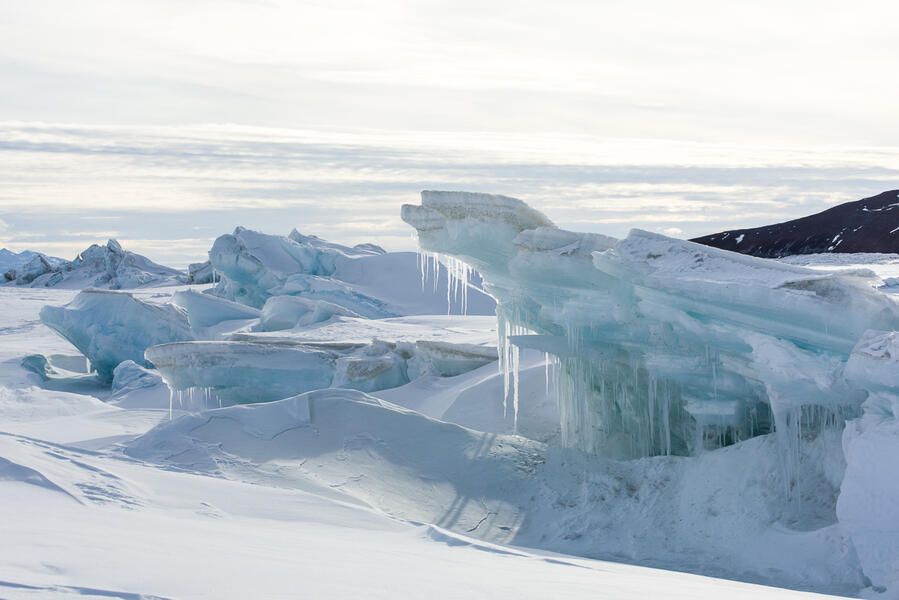
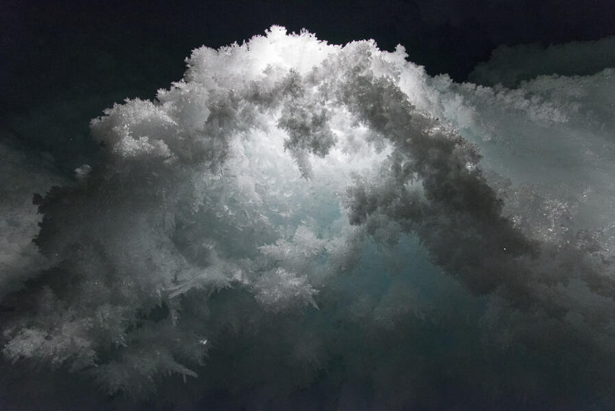 Fractal Arch, Erebus Glacier Ice Tongue Cave(2015) photograph. I went in the ice cave with a mountaineer. When I had him bounce light or backlight the features it brought out a world of intricate, layered fractal patterns.
 -
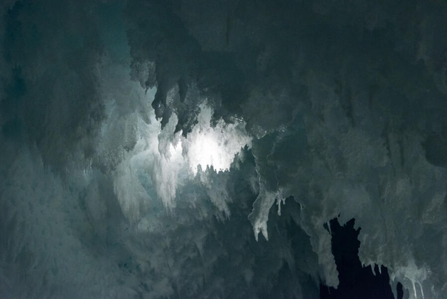 Gothic Ice, Backlit, Erebus Glacier Ice Tongue Cave(2015) photograph. I went in the ice cave with a mountaineer. When I had him bounce light or backlight the features it brought out a world of intricate, layered fractal patterns.
 -
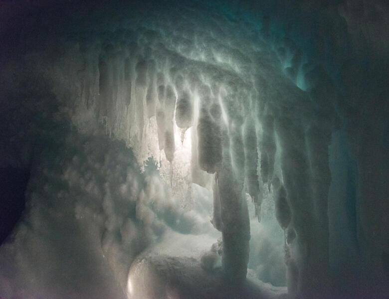 "Stalactites," Erebus Glacier Ice Tongue Cave(2015) photograph. I went in the ice cave with a mountaineer. When I had him bounce light or backlight the features it brought out a world of intricate, layered fractal patterns.
 -
 Blue Fractal, Erebus Glacier Ice Tongue Cave(2015) photograph. I went in the ice cave with a mountaineer. When I had him bounce light or backlight the features it brought out a world of intricate, layered fractal patterns.
 -
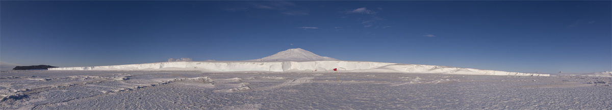
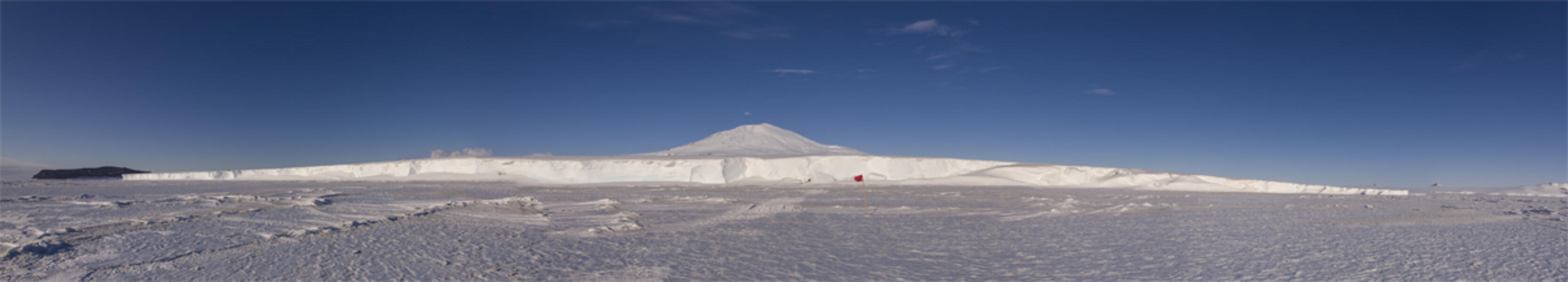 Erebus Ice Tongue Panorama, AntarcticaErebus Ice Tongue, Antarctica (2015) photograph. Photographed from the sea ice looking toward the entrance to the Erebus Ice Tongue cave is marked by a flagged path, roughly in the center of this panorama. In the background is Mt. Erebus, elevation 12,500 ft., the southernmost active volcano.
 -
 Scott Base Pressure Ridge, AntarcticaScott Base Pressure Ridge, Antarctica (2015), photograph, 15 x 22.375 inches. This photo was taken from a hill overlooking the Scott Base pressure ridge. In the distance, on an ice shelf 7 miles away, you can barely make out the planes and buildings of the Williams Airfield, which serves the US and New Zealand bases.
 -
 Scott Base Pressure Ridge, AntarcticaIcicles, Scott Base Pressure Ridge, Antarctica (2015) photograph, 15.25 x 22.375 inches. Close up of the pressure ridge, showing cantilevered ice pushed by tidal forces beneath the six-foot layer of sea ice. In the Antarctic summer, temperatures sometimes warmed to slightly above freezing, and the ice would melt and refreeze.
 -
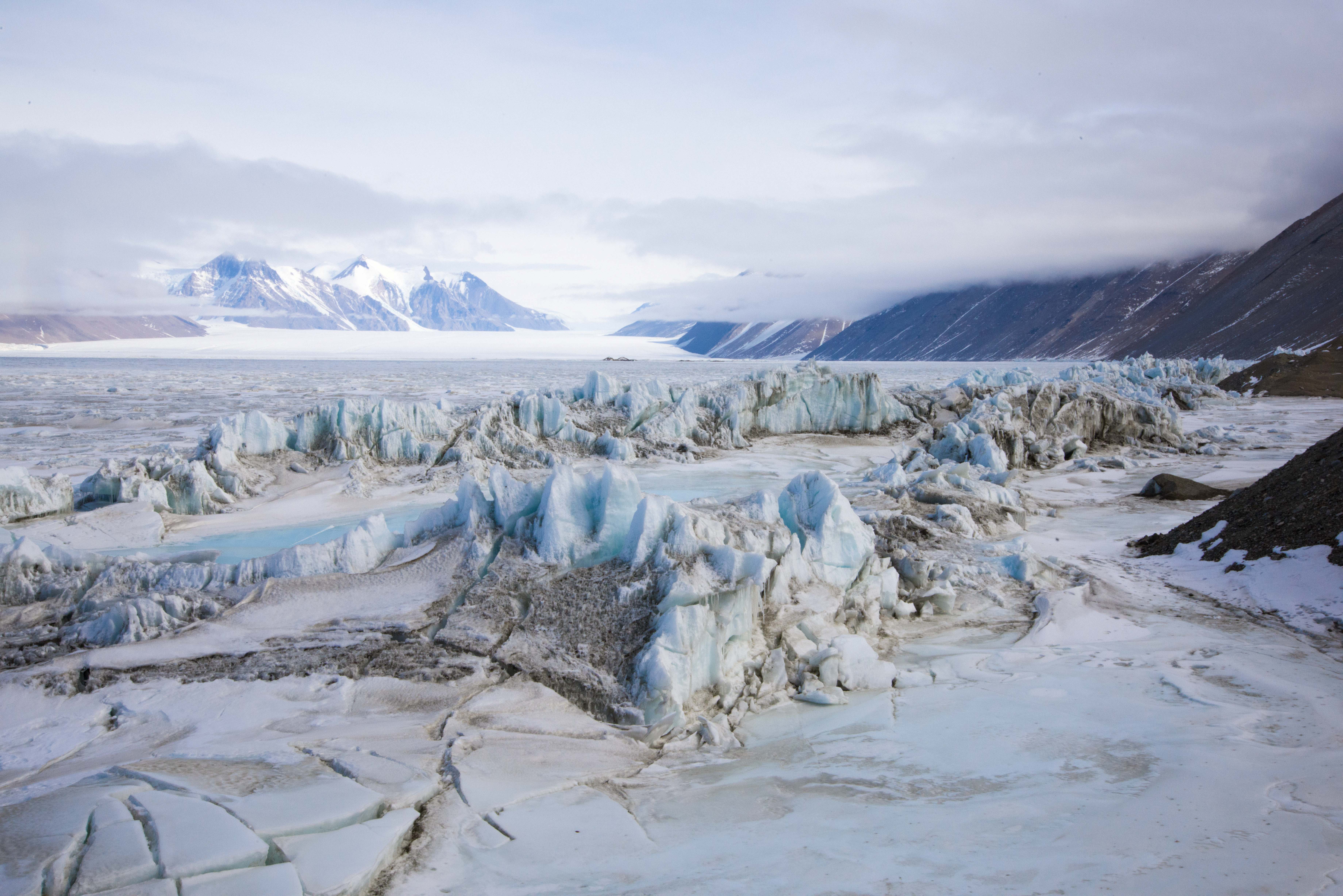
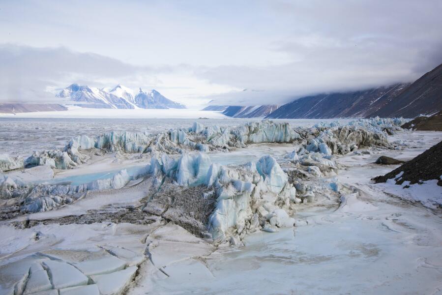 Pressure Ridge Beneath the Double Curtain Glacier, AntarcticaPressure Ridge Beneath the Double Curtain Glacier, Antarctica (2015) photograph, 26.5 x 40 inches. The pressure ridges beneath the Double Curtain Glacier are seldom visited, as they are only accessible by an hour-long trip via snowmobile from the small New Harbor field camp, where I spent four days. This view overlooks the ridge, the sea ice, and the toe of the Ferrar Glacier in the distance.
 -
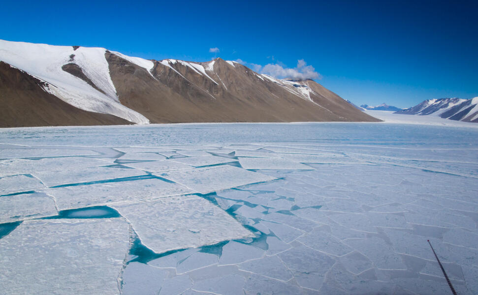 Rectangular Sea Ice, McMurdo Sound, AntarcticaRectangular Sea Ice, McMurdo Sound, Antarctica (2015), photograph, 12 x 18 inches. Photographed from a helicopter in mid-December, the surface of the sound has started to melt during the Antarctic summer, forming remarkably regular rectangular chunks surrounded by blue meltwater. In the distance are the Kukri Hills. The helicopter antennae is in the right foreground. This photograph is on view at the New York Hall of Science through February 2018.


Walking in Antarctica: Antarctic Lake Ice
-
 Skua, Lake Hoare, AntarcticaSkua, Lake Hoare, Antarctica (2015), photograph, 17 x 22.375 inches. This ice formation reminded me of a skua, a gull-like bird that was the only wildlife I saw during my stay in Antarctica, aside from seals and penguins.
 -
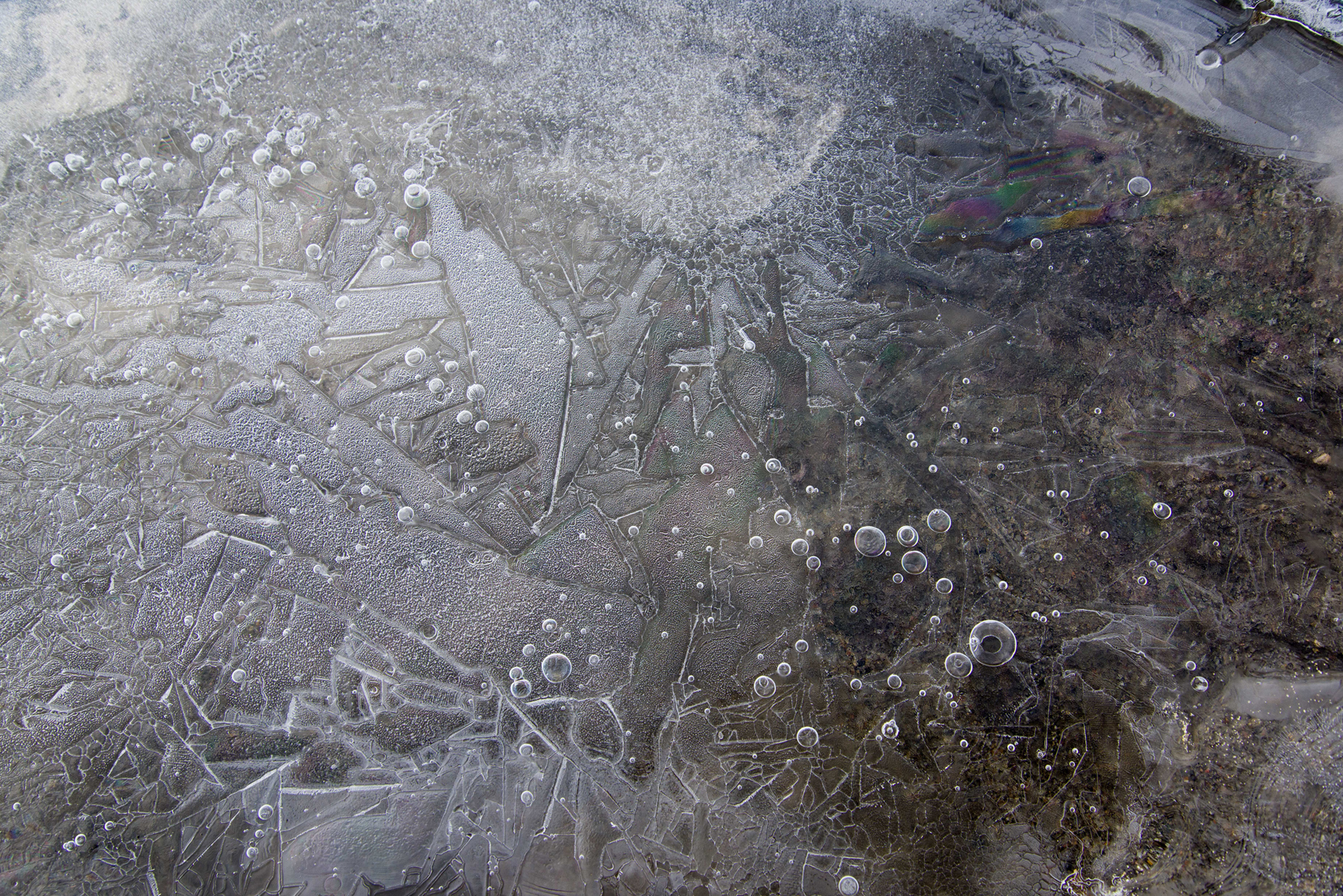
 Primary Ice, Lake Hoare, Antarctica(2015), photograph, 26.75 x 40 inches. Taken at about 1 a.m. under midnight sun, the lake surface is forming what is called "primary ice" in which crystals branch out, forming relief designs that were lit by the slanting sunlight. The designs remind me of Asian ceramics. The ice is framed by reflections of the Canada Glacier and the blue sky.
 -
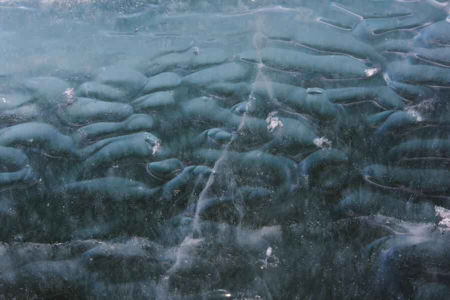
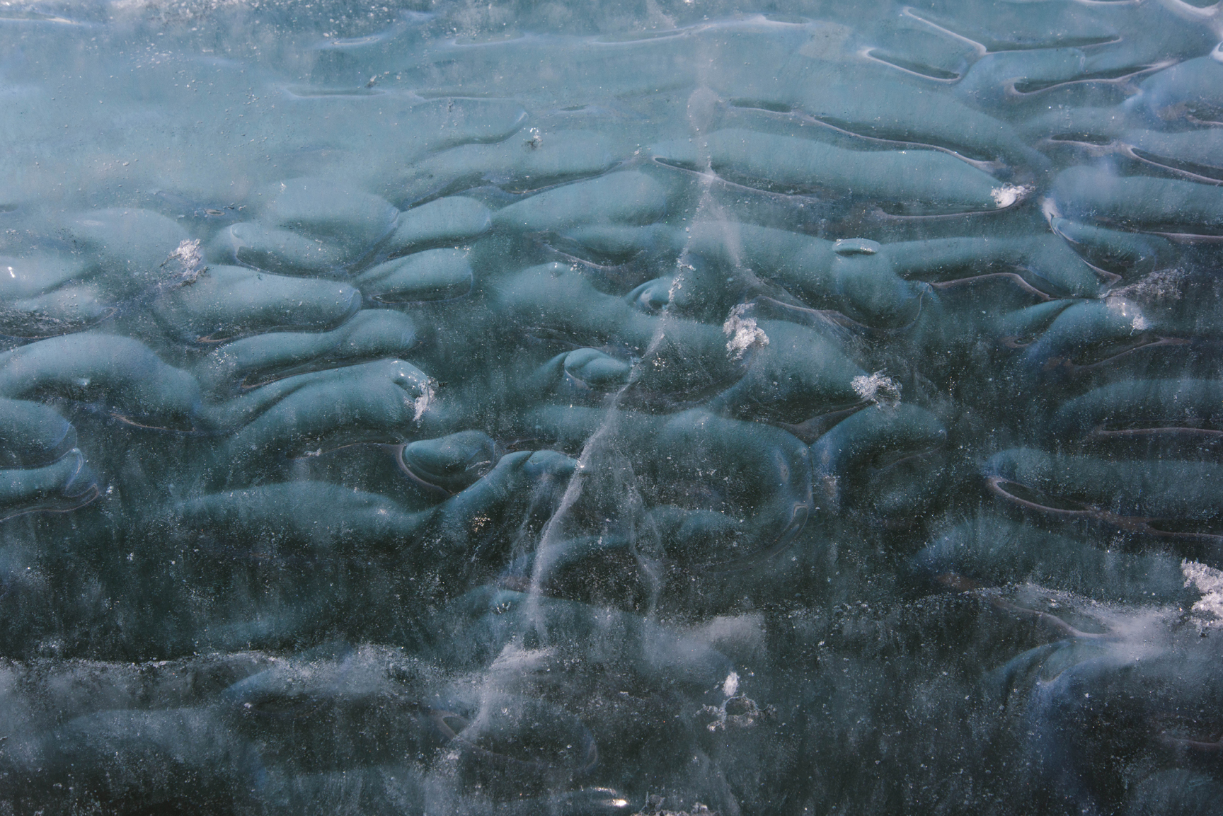
 Loops and Layers, Lake HoareLoops and Layers, Lake Hoare (2015) photograph, 26.75 x 40 inches. Thin lake ice formations that formed over sediment that has blown onto the surface of the lake.
 -
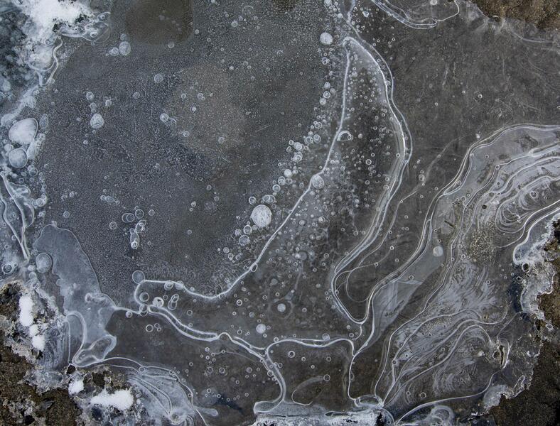
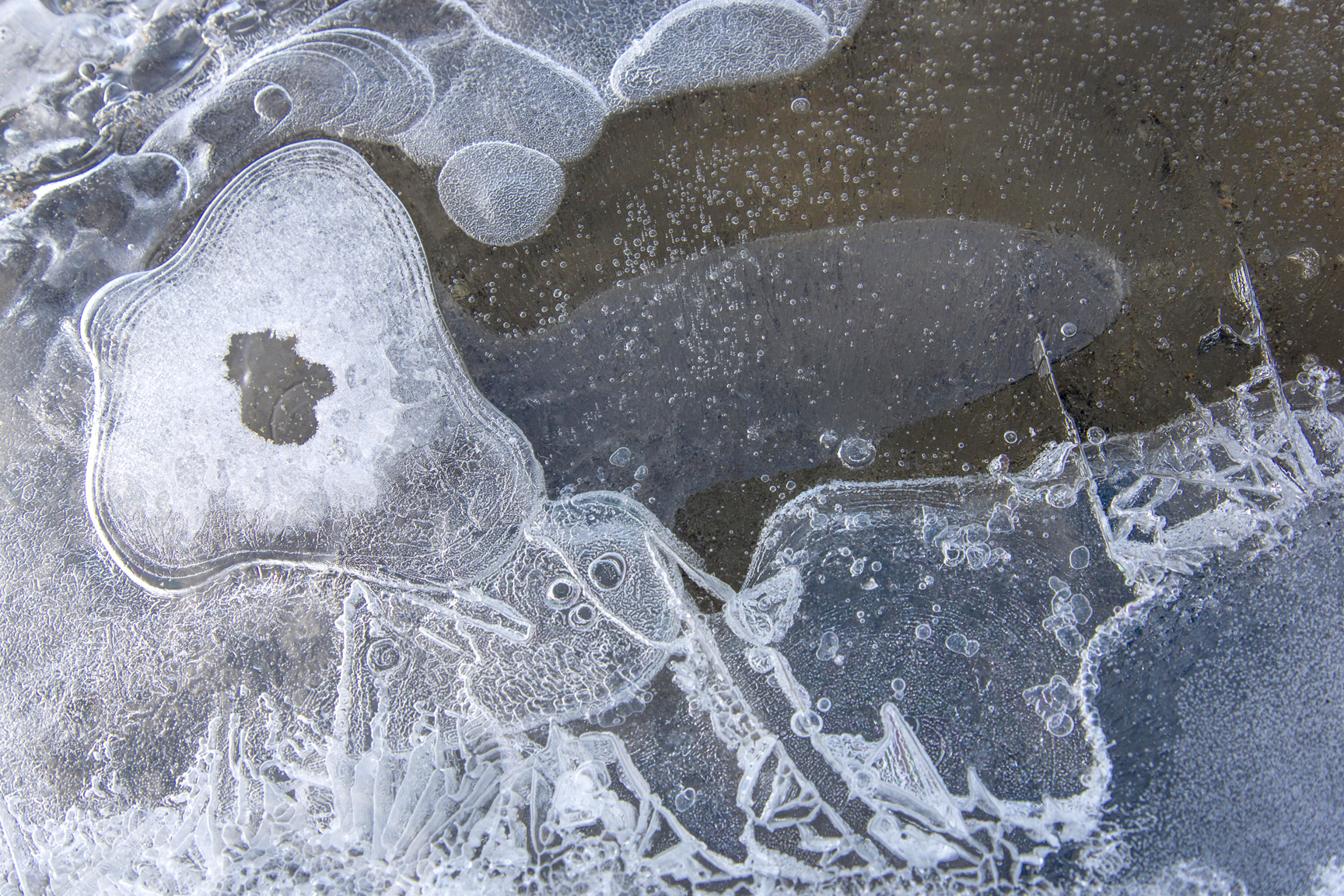
 Vapor Figures and Rainbow, Lake Hoare, AntarcticaVapor Figures and Rainbow, Lake Hoare, Antarctica (2015) photograph, 26.5 x 40 inches. The white etched designs are called Tyndall figures. This formation is richly textured with Tyndalls, frozen bubbles and a colorful interference pattern upper right.
 -
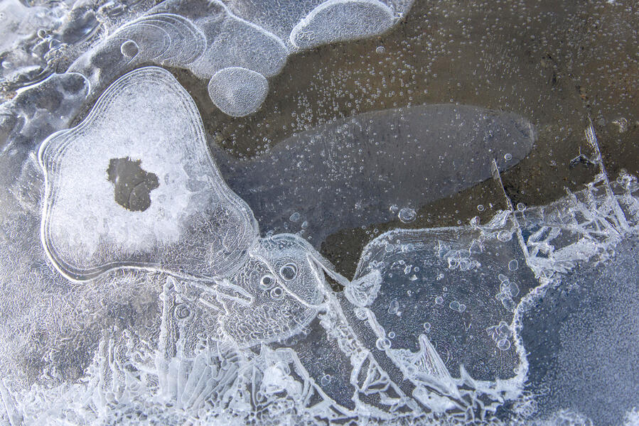
 Oblongs, Cape Royds, AntarcticaOblongs, Cape Royds, Antarctica (2015) photograph, 26.75 x 40 inches. These rounded forms are embedded inside the ice. Glaciologists to whom I showed the photo thought maybe these were formed when a layer of water froze on top of scalloped surface ice, though they said the formations were unusual and unfamiliar.
 -
 Ice Ribbons, Lake Ice at Cape Royds, AntarcticaIce Ribbons, Lake Ice at Cape Royds, Antarctica (2015) photograph, 17 x 24 inches inches. These ribbon-like patterns appear embedded inside the ice of the lake a few feet from the shore. I found them at an inland lake at Cape Royds. I showed them to a group of glaciologists who were in Antarctica studying the sea ice. They were intrigued, though they could not explain the cause.
 -
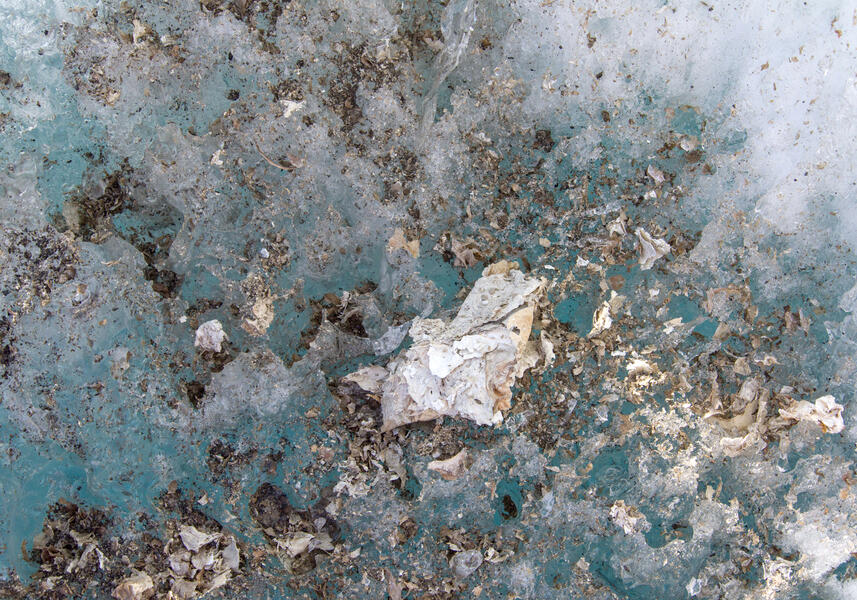 Algal Mat Origami, Cape Royds, Antarctica(2015) photograph, 16.75 x 24 inches or 28 x 40 inches. What looks like torn paper is algal mat that has dried and flaked over blue ice. The ice turns blue when all the air is compressed out of it.
 -
 Sand at Blood Falls, AntarcticaSand at Blood Falls, Antarctica (2015) photograph. The wet sand along the shore of Lake Bonney at Blood Falls was colored by striking shades of green and orange from mineral deposits that seep up and stain the ice.
 -
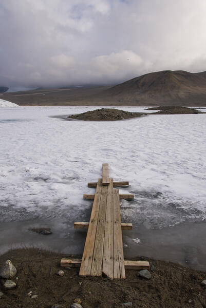 Bridge Onto Lake Hoare, AntarcticaBridge Onto Lake Hoare, Antarctica (2015) photograph, 22 x 14.675 inches. When the margin of Lake Hoare melts in the Antarctic summer, the scientists improvise bridges to get onto the ice. This is how I got to the areas I photographed on Lake Hoare for the other photographs of it in this set.
 -
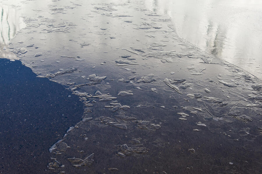
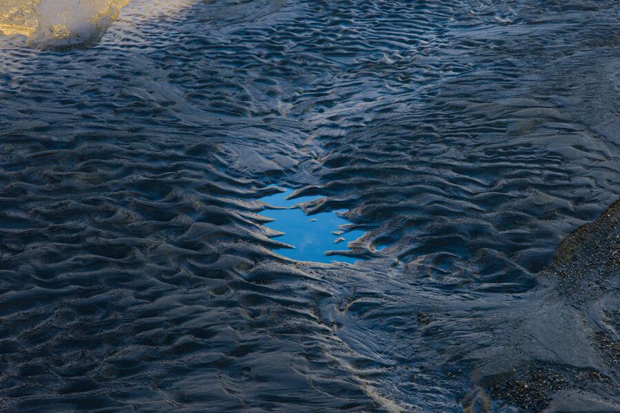 Scallopped Sand, Lake Hoare, AntarcticaScallopped Sand, Lake Hoare, Antarctica (2015) photograph, 26.75 x 40 inches. Sand in the shadow of the Canada Glacier in Antarctica, a puddle in the center reflecting the clear blue sky of 24-hour daylight at 1:20 a.m.


Walking in Antarctica: Ventifacts & Blood Falls, Dry Valleys, Antarctica
-
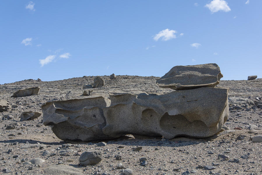
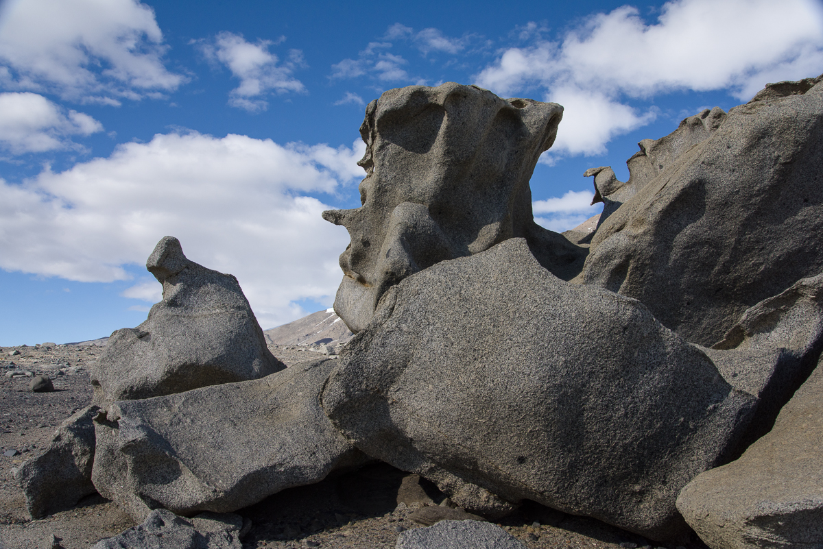
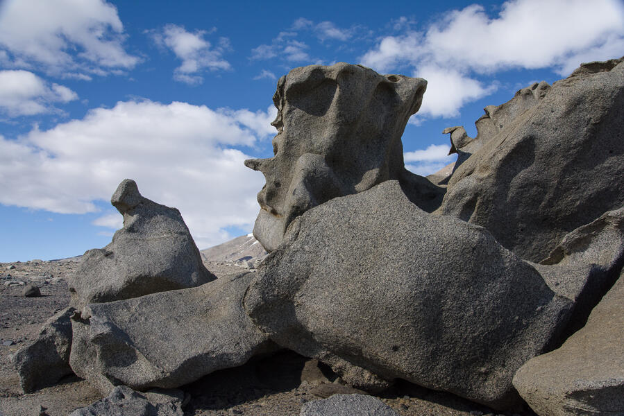 "Seated Figure" Ventifact, Dry Valleys, Antarctica"Seated Figure" Ventifact, Dry Valleys, Antarctica (2015), photograph, 14.675 x 22 inches. The ventifacts present very different sculptural profiles as you walk around them. None of the ventifacts have official names. Any names in quotes are ones I gave them for reference. This one reminded me of a seated figure.
 -
 "Seated Figure" Ventifact, Dry Valleys, Antarctica"Seated Figure" Ventifact, Dry Valleys, Antarctica (2015) photograph. The ventifacts present very different sculptural profiles as you walk around them. Compare this to the previous and following photo of the same formation. None of the ventifacts have official names. Any names in quotes are ones I gave them for reference.
 -
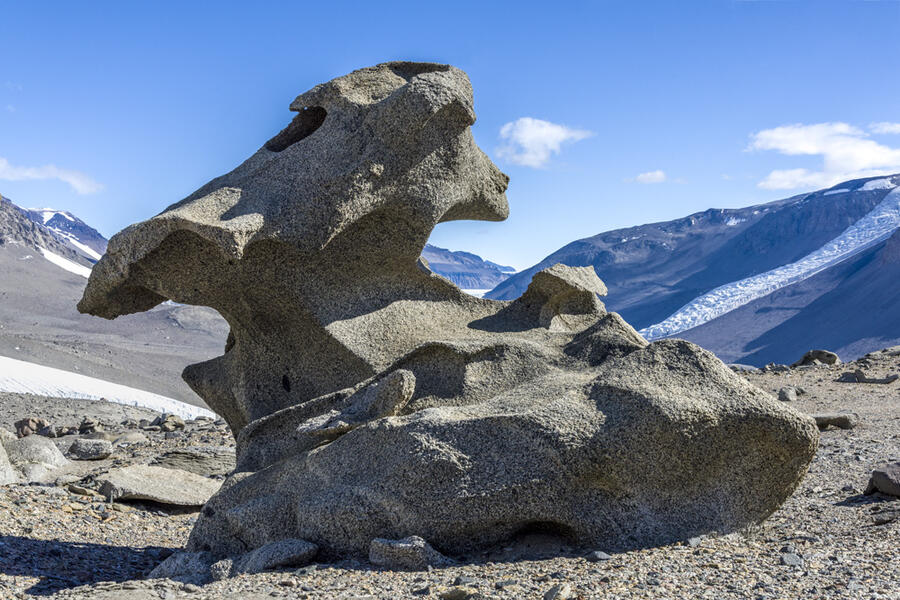
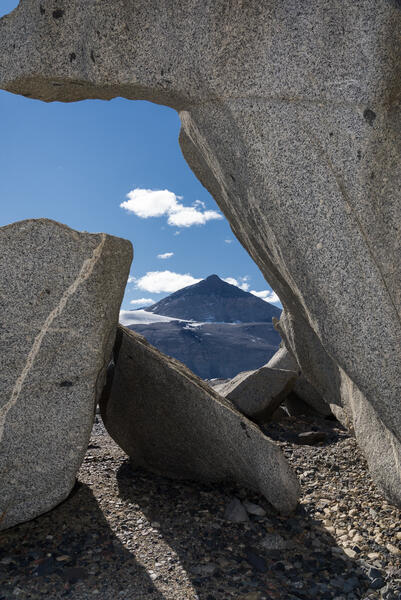 Matterhorn Framed by Ventifacts, Dry Valleys, AntarcticaMatterhorn Framed by Ventifacts, Dry Valleys, Antarctica (2015), photograph, 22.375 x 15 inches. This is another view of the "Seated Figure" ventifact shown in two other photographs. It frames a view of a mountain peak on the opposite side of the valley called The Matterhorn.
 -
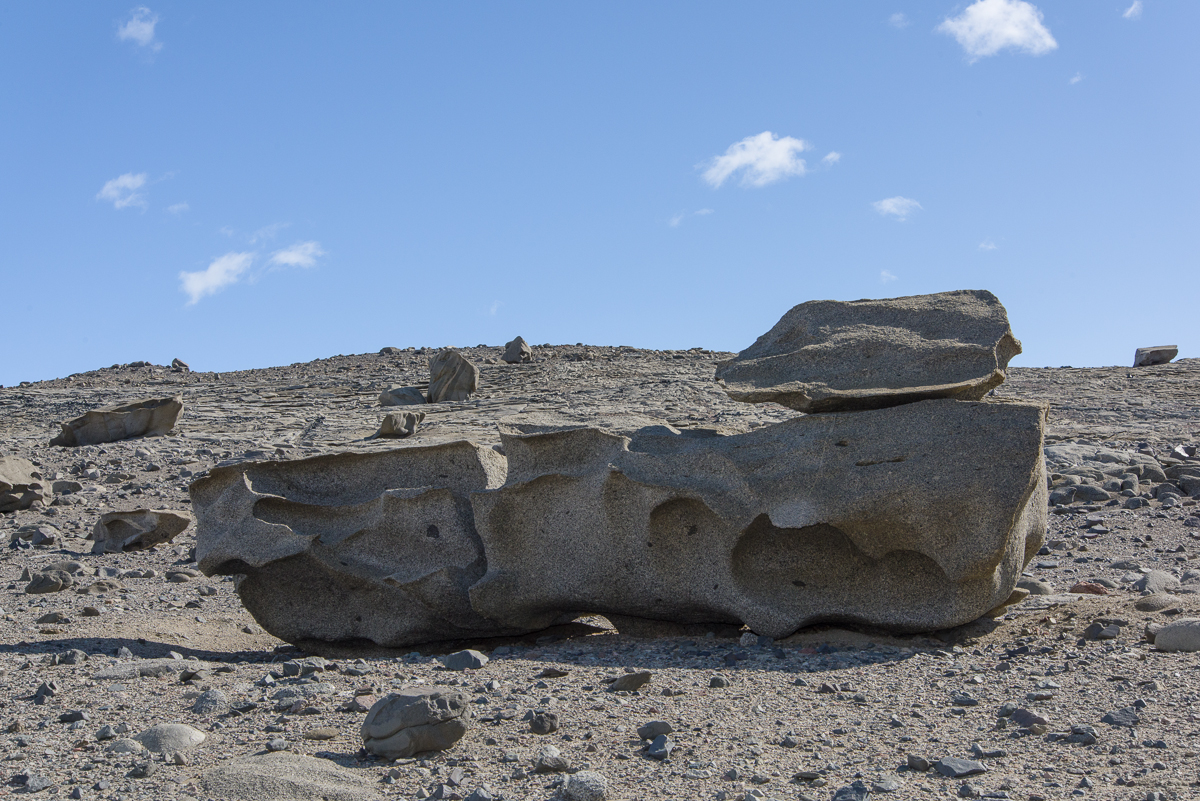
 "Tanguy" Ventifact, Dry Valleys, Antarctica"Tanguy" Ventifact, Dry Valleys, Antarctica (2015), photograph,13.75 x 22 inches. None of the ventifacts have official names. Any names in quotes are ones I gave them for reference. This one reminds me of Surrealist landscape paintings by Yves Tanguy from the mid 20th century. It is also a source photo intended for eventual processing as a 3D file and sculpture.
 -
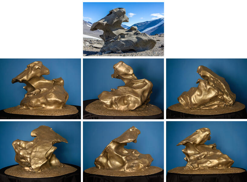
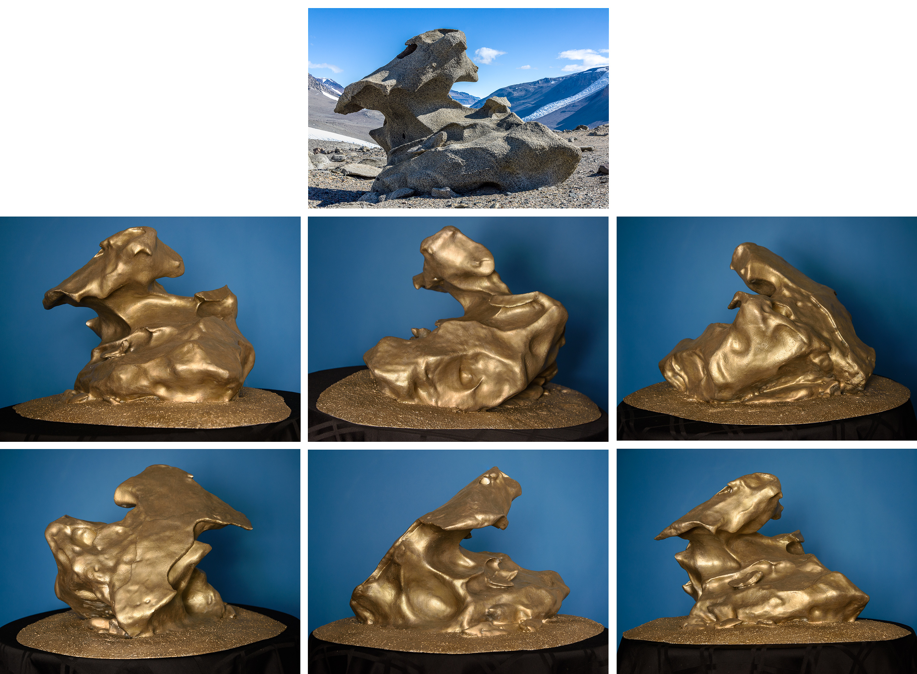
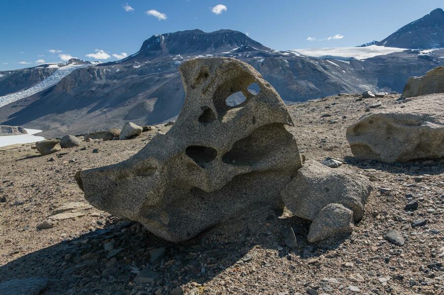 06 Glazer Bird Ventifact.jpg"Bird" Ventifact, Dry Valleys, Antarctica (2015) photograph, 14.75 x 22 inches. Source photo for the 3D scan from which I made the sculpture shown in other images of this project. None has an official name, but it reminded me of a bird.
 -
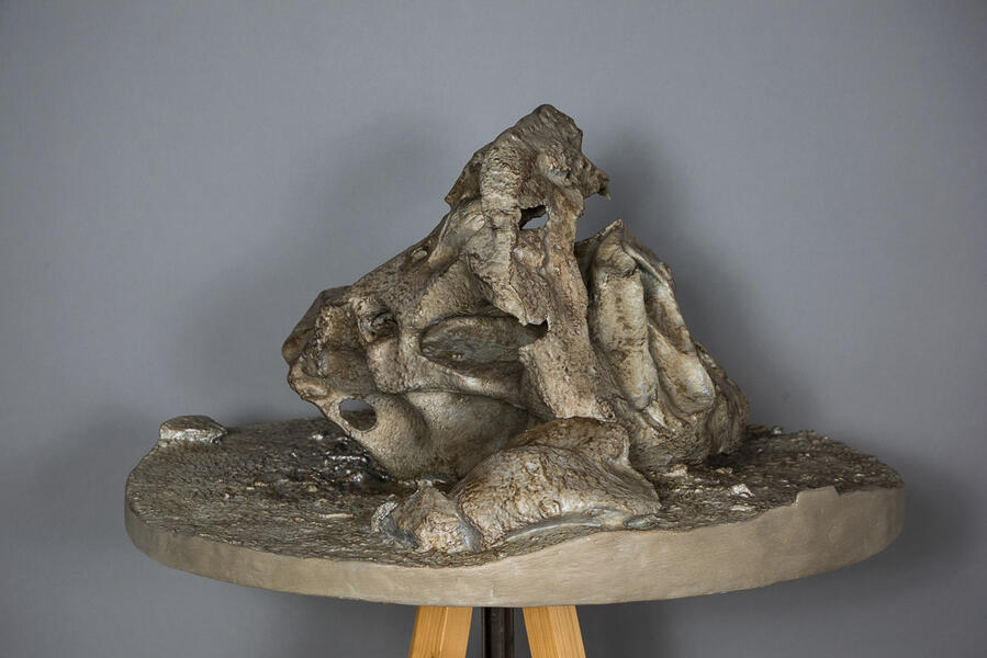
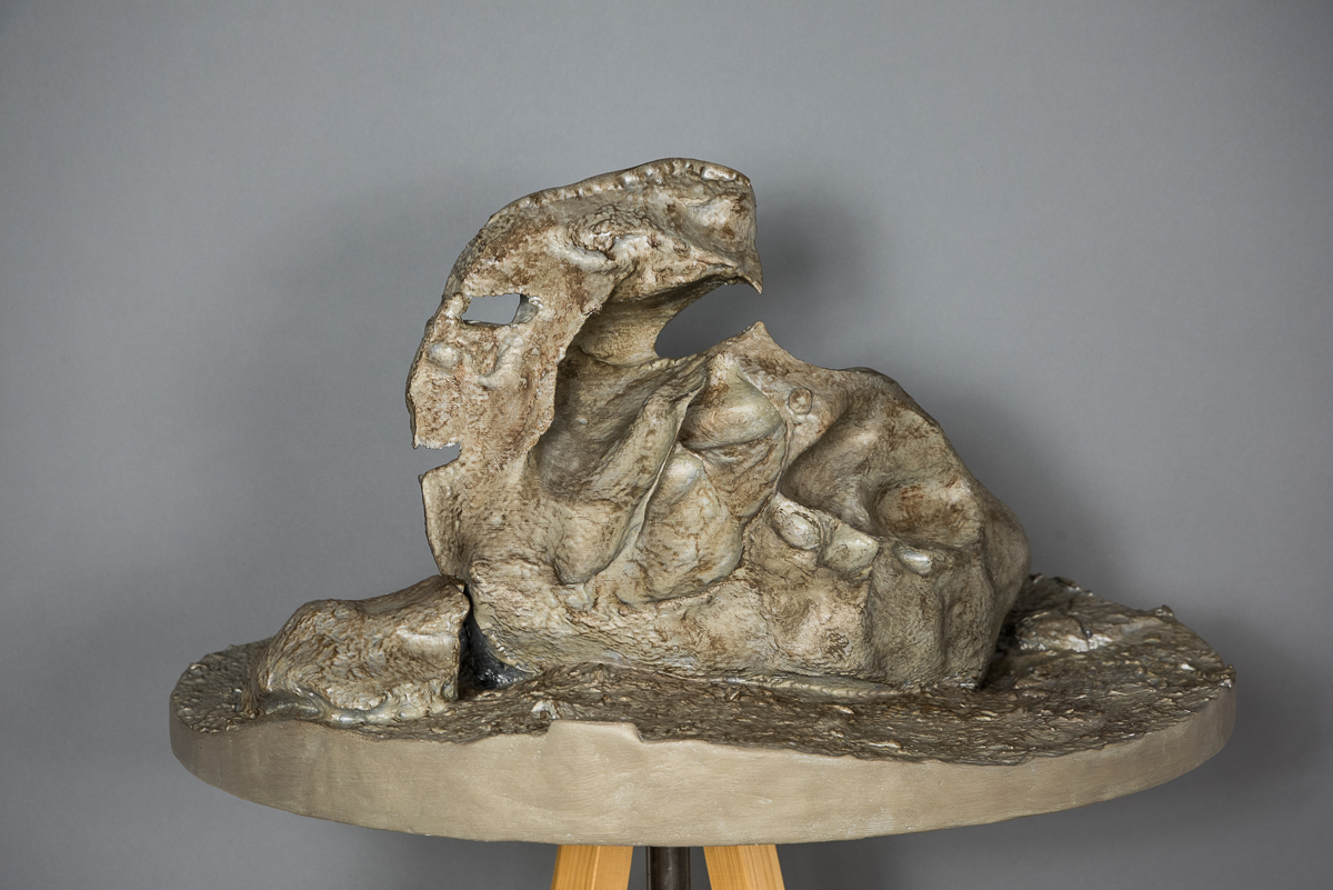
 "Bird" Ventifact, Dry Valleys, Antarctica"Bird" Ventifact, Dry Valleys, Antarctica (2016), acrylic on 3D-printed PLA plastic and polymer-modified gypsum, 16 x 29.5 x 29.5 inches. At the top of the steep, gravel-covered hill above Lake Bonney in the McMurdo Dry Valleys is a plateau strewn with ventifacts, giant boulders eroded into strange shapes by fierce winds. I called it the Surrealist sculpture garden. I made a 3D scan of this six-foot-tall boulder and printed it in sections on a 3D printer. A video of the process is shown on YouTube: https://www.youtube.com/watch?v=qdY3xDGPDf0
 -
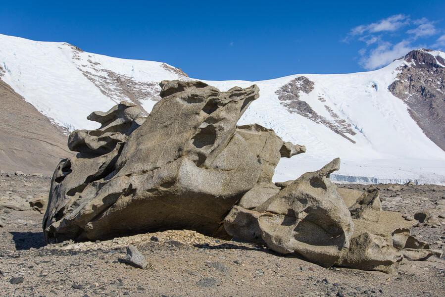
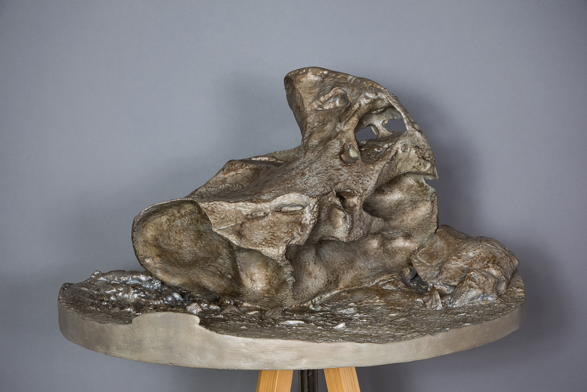
 "Pterodactyl" Ventifact, Dry Valleys, Antarctica(2015/2019) archival pigment print, 12 x 18 inches. At the top of the steep, gravel-covered hill above Lake Bonney is a plateau strewn with ventifacts, giant boulders eroded into strange shapes by freeze/thaw cycles and fierce winds. This is one of the source photos for the sculpture also shown here.
 -
 "Pterodactyl" Ventifact, Dry Valleys, Antarctica(2019) acrylic on 3D-printed PLA plastic, 16 x 24.5 x 29.5 inches. 3D printed sculpture generated from still photos taken on site, via photogrammetry.


Legacy of the US Air Base from "Kangerlussuaq: Cold War, Warming Climate"
-
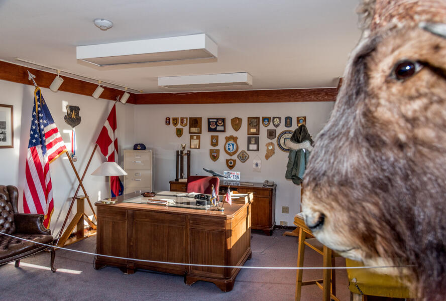 Base Commanders Office, Kangerlussuaq MuseumIn 1992, the American air base commander turned over the keys to the buildings to the local airport authorities and left the contents intact at their request, including his US military issue parka and the trophy musk ox head on the wall. It is preserved today in the town museum.
 -
 2021-0928 + RS184472 Signpost Composite-2.jpg
Helen Glazer Signpost, Kangerlussuaq Airport (2021)
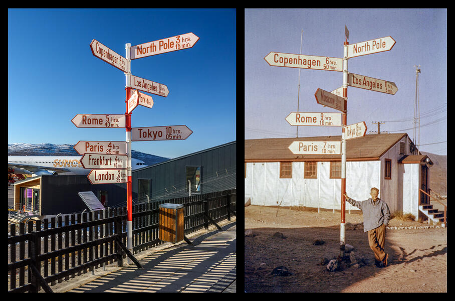
Unidentifed photographer, Andreas Lund-Drosvad with Signpost (1959) (Collection Danish Arctic Institute)Kangerlussuaq’s iconic red and white signpost originally stood in front of this museum building, then the Danish Hotel before being relocated to the airport. In 2014 the signpost was renovated by Air Greenland, changing the flight times, adding cities, and removing the SAS company emblem from the top. Andreas “Suko” Lund-Drosvad (1899-1989) posed with the sign in 1959. He was came to Greenland in the 1920s and settled in Upernavik where he lived for many decades and established the Upernavik Museum. This pair of photographs is part of a permanent installation at the Kangerlussuaq Museum in a room devoted to my photographs juxtaposed with vintage photos of similar sites related to the town's history as a military and scientific research outpost.
-
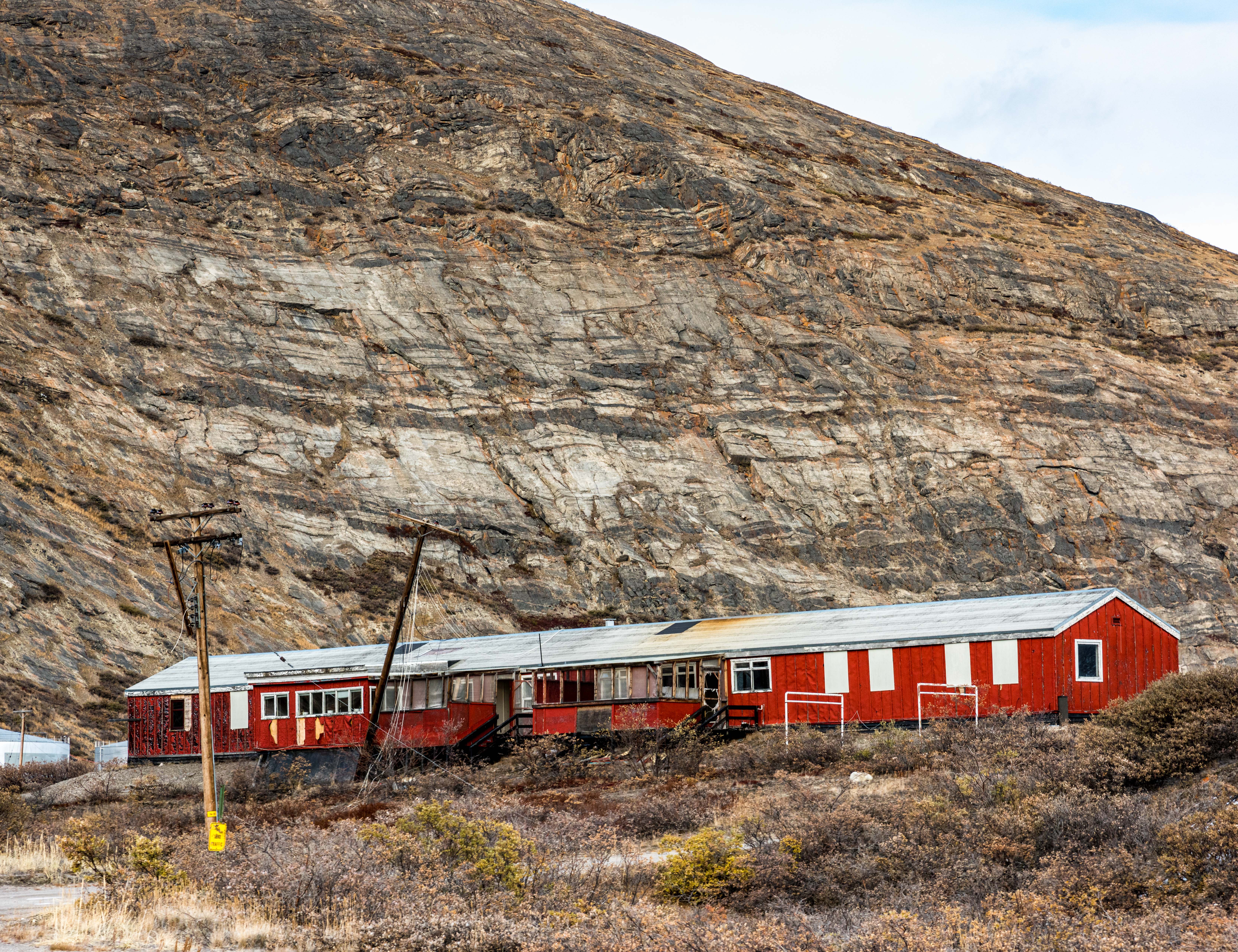
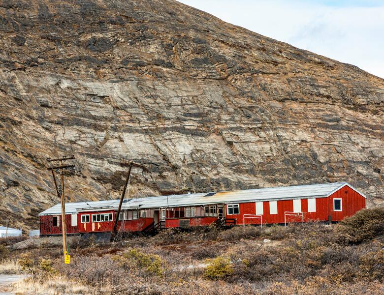 Sondrestrom Offshore Transit Home(2021) The former Offshore Transit Home of the Sondrestrom Air Base is one of many abandoned military buildings I photographed. This one is in the part of town known as Old Camp, where barracks for Danish troops and facilities for the entire base were located. Dozens of disconnected telephone poles like the ones here are found throughout the base. (They were shipped here by the US military from outside Greenland which has no native trees that grow more than a few feet high.) They are gradually being cut down and added to a huge pile in the town junkyard.
 -
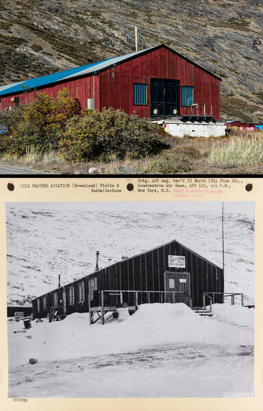 The Dirty Shame Saloon 2021 and 1954Part of my project involves rephotographing sites in old photos of the air base as they look today. My 2021 photograph of an abandoned building is shown here with a rephotographed 1954 mounted print from the U.S. National Archives when it was The Dirty Shame Saloon.
 -
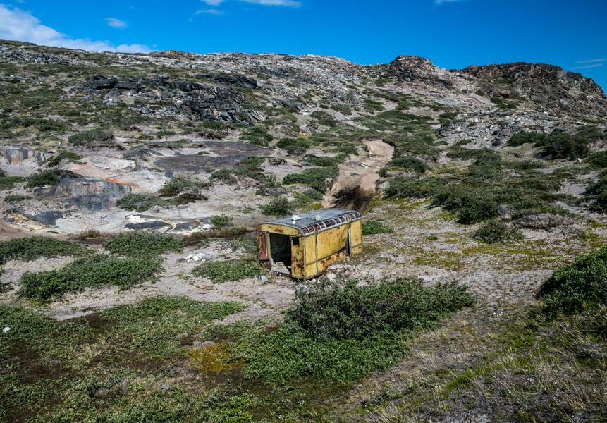 Abandoned Hut Near the Russell GlacierIt's a mystery: Who transported this hut to an isolated patch of tundra across the river from the Russell Glacier in Kangerlussuaq — and why? Before posting it here I asked a Facebook group of American and Danish veterans of the former Sondrestrom Air Base and they didn't know either — men who were deployed as long ago as 1972 said they'd always wondered the same thing (one posted a 50-year-old photo of himself standing beside it). You can see in these photos that it has slid downhill from its original spot, and that the interior is covered with graffiti going back to the 1950s.
 -
 Kangerlussuaq Junkyard(2022) The Kangerlussuaq junkyard is an astonishing place, a semi-organized conglomeration of the discarded appliances and household items you'd see in any town dump alongside decades-old relics of the US military base that closed 30 years ago: obsolete vehicles and machinery; dozens of telephone poles, empty oil drums, and fuel tanks; and stacks of scrap metal. Missing from the US's agreement with Denmark authorizing the building of Greenland's Cold War bases in 1951 was a plan for disposing of anything brought in when it was no longer needed.
 -
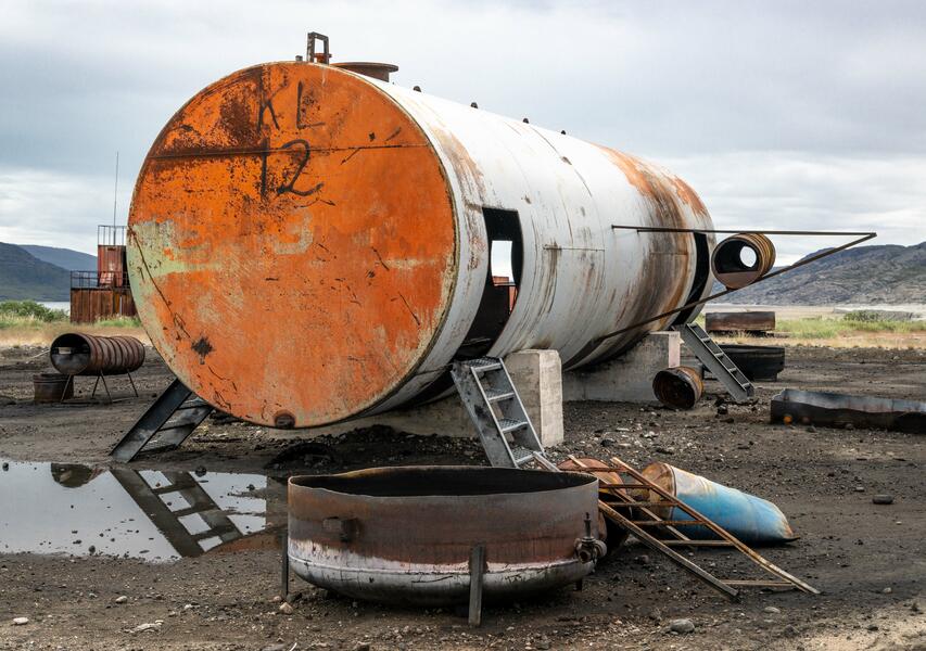 Mock Airplane for Firefighter Training(2022) On the outskirts of town, an old fuel tank and barrels from the former American air base has been repurposed into a mockup of an airplane crash for firefighter training. (Most cities in Greenland are only connected by air or boat, so air travel into and out of the town's airport is constant throughout the day.)
 -
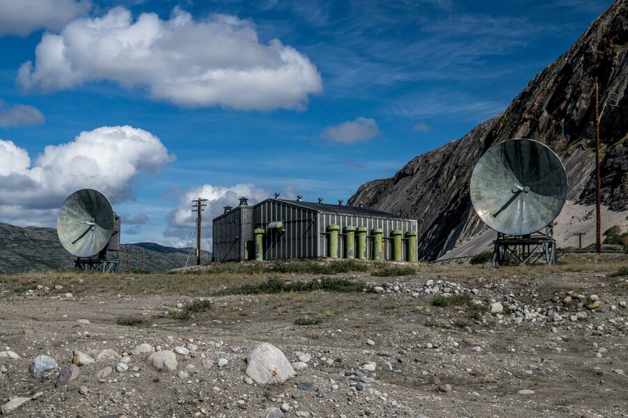 "Mickey Mouse" Decommissioned Radar DishesErected over 60 years ago, this pair of decommissioned Cold War era radar dishes and radio terminal building left behind by US military have become a landmark locals refer to as "Mickey Mouse," as in, "Follow the road past Mickey Mouse..." Before the dish technology became obsolete in the late 1980s, they served as relay antennae channeling all communications to and from scattered radar sites for the Distant Early Warning missile defense system that stretched across the Arctic from Greenland to Alaska. I have found photos of them from 1961 in the US National Archives.
 -
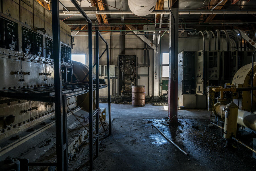 Abandoned Generator Station Interior(2022) Interior of the abandoned generator building atop a hill near the Kangerlussuaq Harbor. The massive machines with interiors still coated with inky grease have sat unused for at least 30 years.
 -
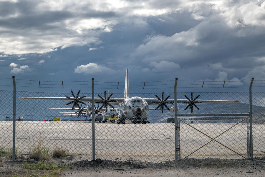 US Air Force Planes on Runway(2022) Four US Air Force planes parked on the Kangerlussuaq Airport runway in 2022. Although Sondrestrom Air Base closed in 1992, the New York Air National Guard, which flies transport planes in the Arctic and Antarctic, maintains a small presence there and still trains in Kangerlussuaq.


The Journey of Ice Part 1 from "Kangerlussuaq: Cold War, Warming Climate"
-
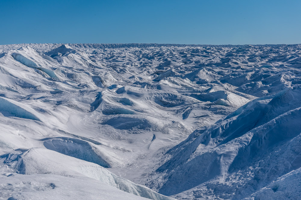
 Greenland Ice Sheet
(2021) Standing on the ice sheet that covers 80% of Greenland, looking inland. Photo taken in mid-September after several days of freezing temperatures and a snowfall of a few inches froze the meltwater streams.
-
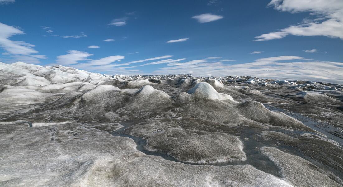
 Ice Cap at Point 660, Midsummer
(2022) The edge of the Greenland ice cap in midsummer when streams of meltwater form between the mounds of ice. Gravel blown onto the icy crust makes this image resemble a pencil drawing.
-
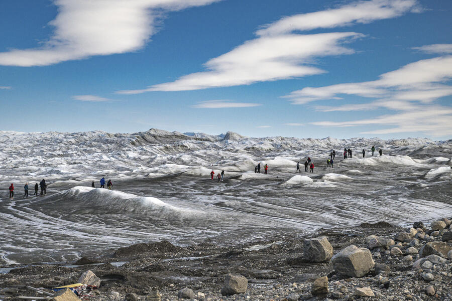 Tour Group Walking on the Ice, Point 660
(2022) The road’s end, known as Point 660, provides a benchmark for the effects of climate change. In 2001 when the auto testing project was active, vehicles could drive directly onto the ice cap from the end of the road. Now visitors walk down the steep gravel hill formerly covered by the ice cap in the foreground of this photograph. As the ice sheet melts and its edge recedes inland, it also uncovers permafrost (a layer of soil that is frozen year round). A print of this photograph is in the permanent installation at the Kangerlussuaq Museum.
-
 Retreating Edge of the Greenland Ice Cap, Point 660
(2022) 20 years ago, the ice cap that covers 80 percent of Greenland also covered the steep moraine on the left. The ice has since retreated inland. (A regional government official told me that the ice formerly covering the moraine has dropped 30 to 50 meters since then.) In July, a swiftly flowing stream filled by meltwater from the ice cap divided the ice cap edge from the melting permafrost of the moraine.
-
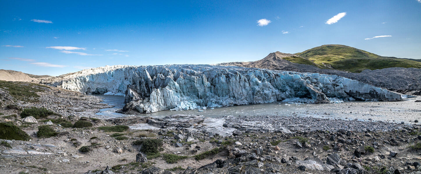 Russell Glacier Panorama
(2022) The Russell Glacier flows off the Greenland ice cap. The Danish Arctic Institute has photographs from the 1950s taken by glaciologist Borge Fristrup (see next image), who conducted research there over several season. The photos show that the face of the glacier has eroded considerably since then and the height has noticeably dropped. They are both in the permanent installation at the Kangerlussuaq Museum to show the impact of climate change on this local landmark.
-
 The Russell Glacier in 1955
(1955) The Russell Glacier flows off the Greenland ice sheet. Its front is located 25 km east of Kangerlussuaq. When my 2022 photograph is compared with one taken by Danish glaciologist Børge Fristrup in 1955 one sees the ice loss over those decades. Fristrup (1918-1985) participated in and led a number of scientific expeditions iand played a major role in investigations of the Greenland ice sheet. (Fristrup photo courtesy Danish Arctic Institute). A comparison of these two images is part of the permanent installation at the Kangerlussuaq Museum.
-
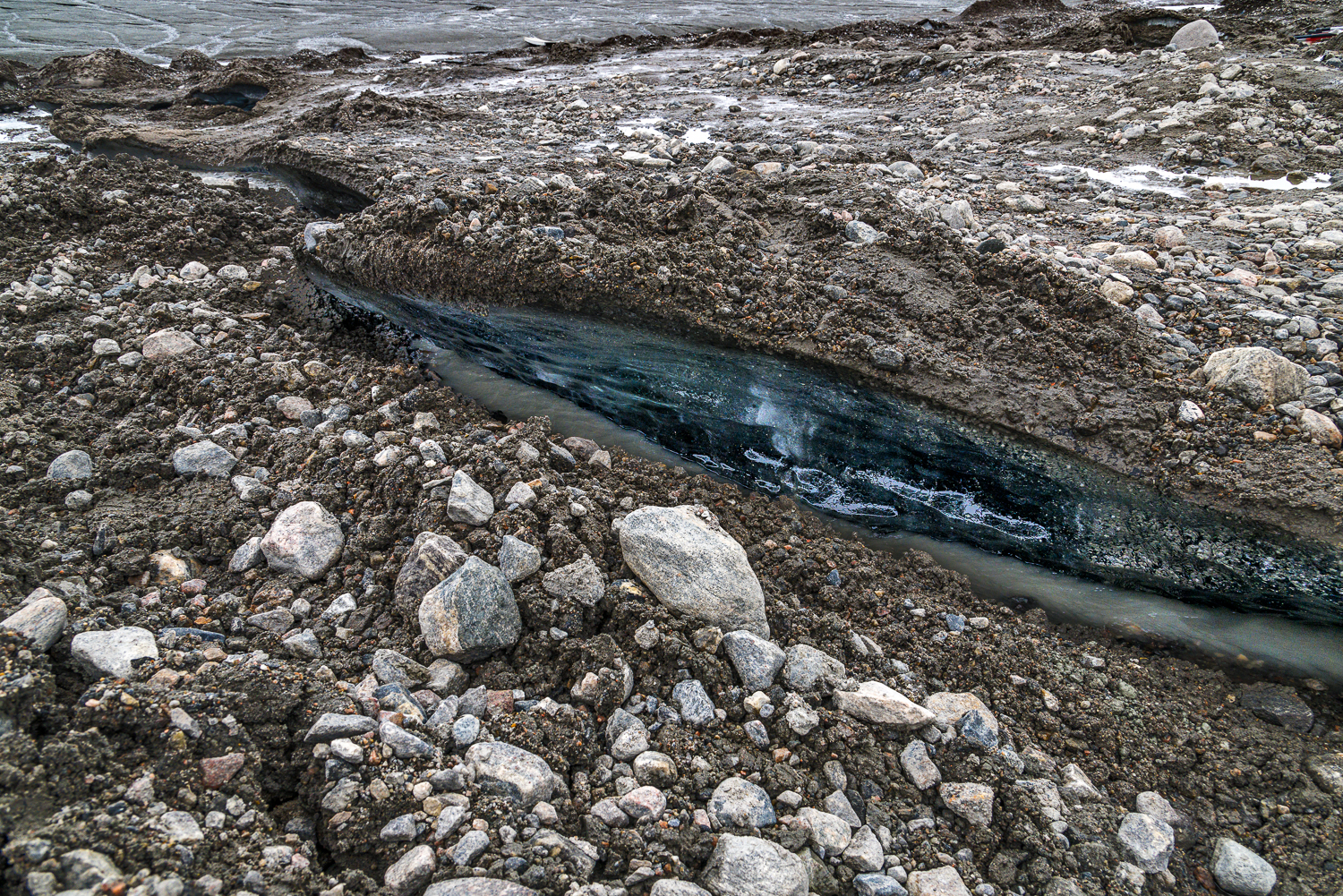
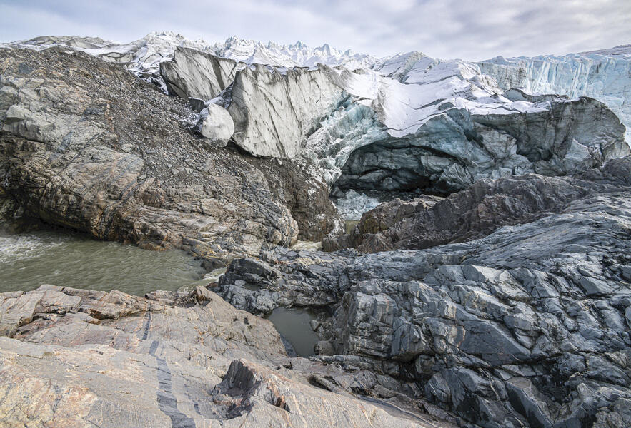 Waterfall at the Russell Glacier
(2023) Meltwater flowing off the Greenland ice cap gathers force as it enters the river that flows past the Russell Glacier, which is part of the ice cap, eroding a cave that has been rapidly enlarging in the past few years.
-
 Site of the 3D scan of the ice cap
(2022) Panoramic photo of the site where I made the 3D scan of the ice cap for the sculpture shown in the next image.
-
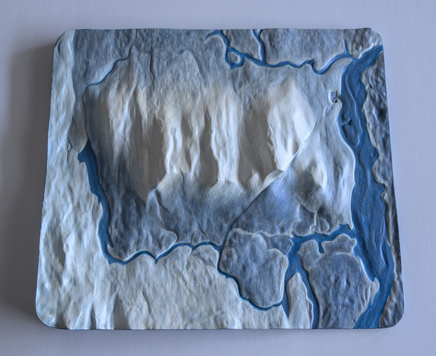
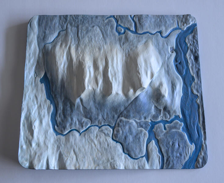 Greenland Ice Cap in Midsummer
(2023). This sculpture was made from a 3D scan of a small section of the ice cap near Point 660 for the permanent installation at the Kangerlussuaq Museum. The dark blue represents the streams of water that had formed under the summer sun. To make the sculpture, first a series of photographs of the scene from different angles were processed into a 3D file using photogrammetry software. After editing the file with 3D modeling software, it was carved in high density urethane foam by a machine that can read 3D files. Since the ice is constantly changing — and melting — this is a permanent record of a temporary form.
-
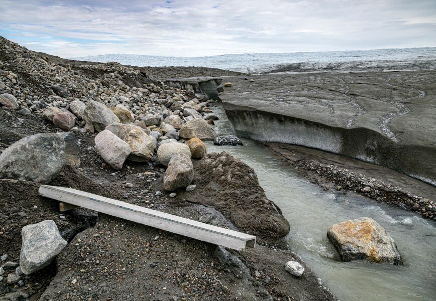
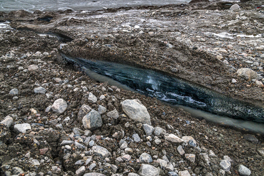 Permafrost Cracks, Point 660
(2022). 20 years ago, this rocky area crossed by visitors to Point 660 to walk onto the ice cap was covered by the ice sheet. As the ice sheet melts and its edge recedes inland, it uncovers the permafrost (a layer of soil that is frozen year round) to the sun. Without its cover of white ice to reflect the sun’s rays, the dark soil absorbs heat, melting the permafrost, so large cracks have now developed, exposing once-buried ice. Streams of meltwater run through these cracks in the summer.


The Journey of Ice Part II from "Kangerlussuaq: Cold War, Warming Climate"
-
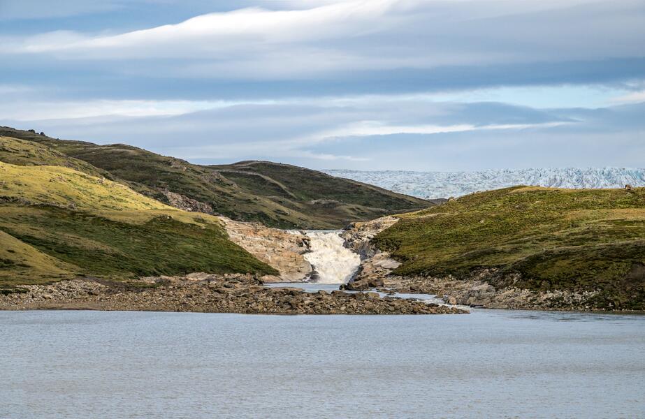 Waterfall from the Ice Cap to the River(2022) Meltstreams off the ice cap in summer collect here and flow down a waterfall and into the river that winds some 19 miles to the mouth of the fjord.
 -
 Reindeer Glacier Ice Loss Between 2018 and 2022
Photographs taken on my first visit to Kangerlussuaq (a one-day visit as part of a tour in 2018, top) and when I returned four years later (bottom) show the extent of the ice loss over that period, in terms of the overall elevation of the ice, the portion extending into the river, and the portion over the dark gravel hill on the right. "Reindeer Glacier" is the local nickname for this portion of the ice cap. These photographs are part of the permanent installation at the Kangerlussuaq Museum.
-
 Akuliarusiarsuup Kuua and Sugarloaf(2022) The Akuliarusiarsuup Kuua is a river of meltwater from the Greenland ice cap, some 20 miles to the east.
 -
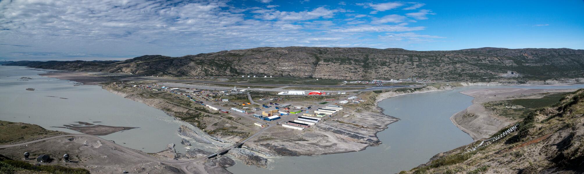 Kangerlussuaq Panorama from Black Ridge
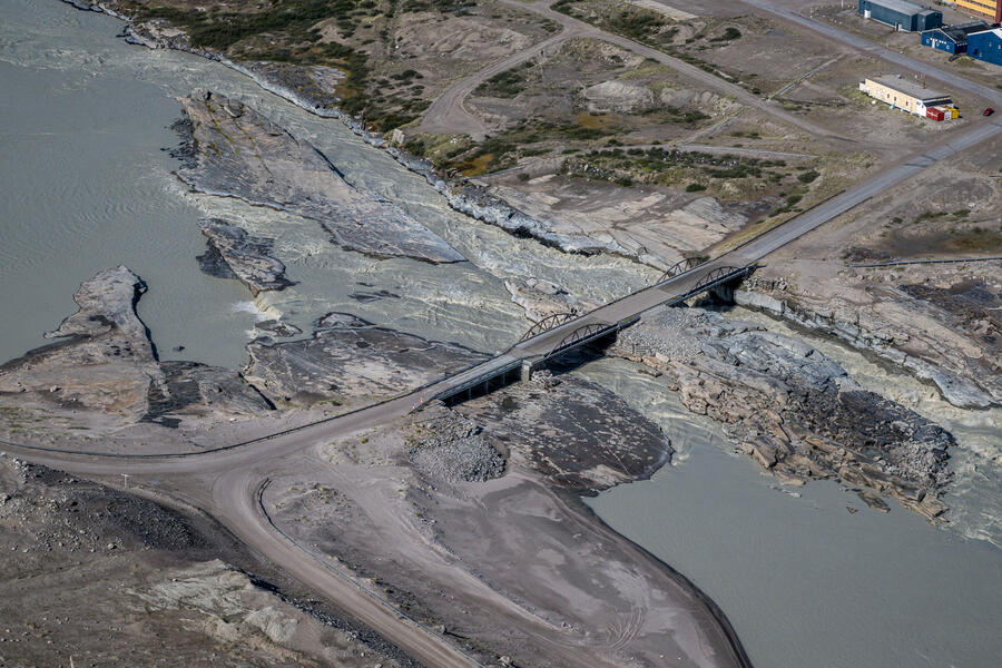
(2022) A panorama of the town from the top of Black Ridge (elev. 360 feet), a hill overlooking the confluence of the river from the ice cap and the fjord leading out to sea (located where the bridge is). Most of the buildings were originally built by the American military which also blasted two channels beneath where the bridge is now so the area around the shore wouldn't flood during the summer melt season. The sites shown in the next 5 photographs can all be seen from right to left in this panorama, following the direction of the river flow. This photograph is part of the permanent installation at the Kangerlussuaq Museum.
-
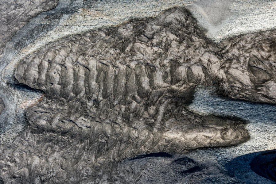
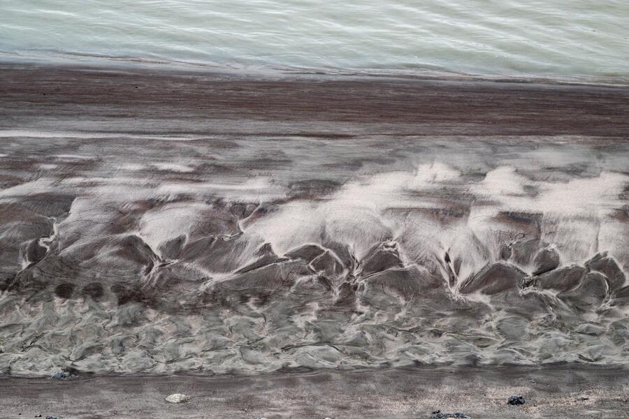 Glacial Silt, Riverbank
(2022) A close-up of the wave-like patterns of silt on the rocks just before the town bridge where the river empties into the Kangerlussuaq Fjord. The river is fed by melting of the Greenland ice cap flowing off the Russell Glacier, which in the summer months is milky with fine glacial silt. As one scientist puts it, "By the time it gets to Kangerlussuaq and passes under the town’s bridge, it’s essentially a rock, soil, and sand smoothie."
-
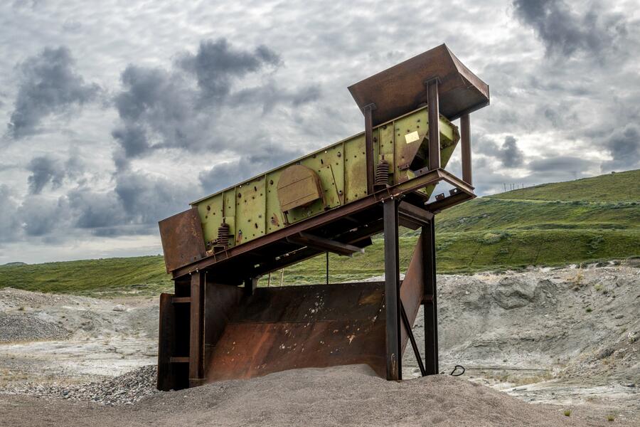 Stone Sorter, "Dust City"(2022) During the days of the Sondrestrom Air Base, soldiers called the broad sandy riverbank next to the town "Dust City." This vintage stone sorter and two other nearby pieces of equipment were used by the base — and still sometimes today — for sifting gravel for road repair.
 -
 2022-0731-39.jpg
The American military blasted two channels beneath where the bridge is now so the area around the shore wouldn't flood during the summer melt season. It has altered the ecology so that more silt flows into the fjord, so that where once there was a pier where boats could dock near town, the water is now too shallow. This photograph is on a two-page spread in the book The New Geologic Epoch (ecoartspace, 2023).
-
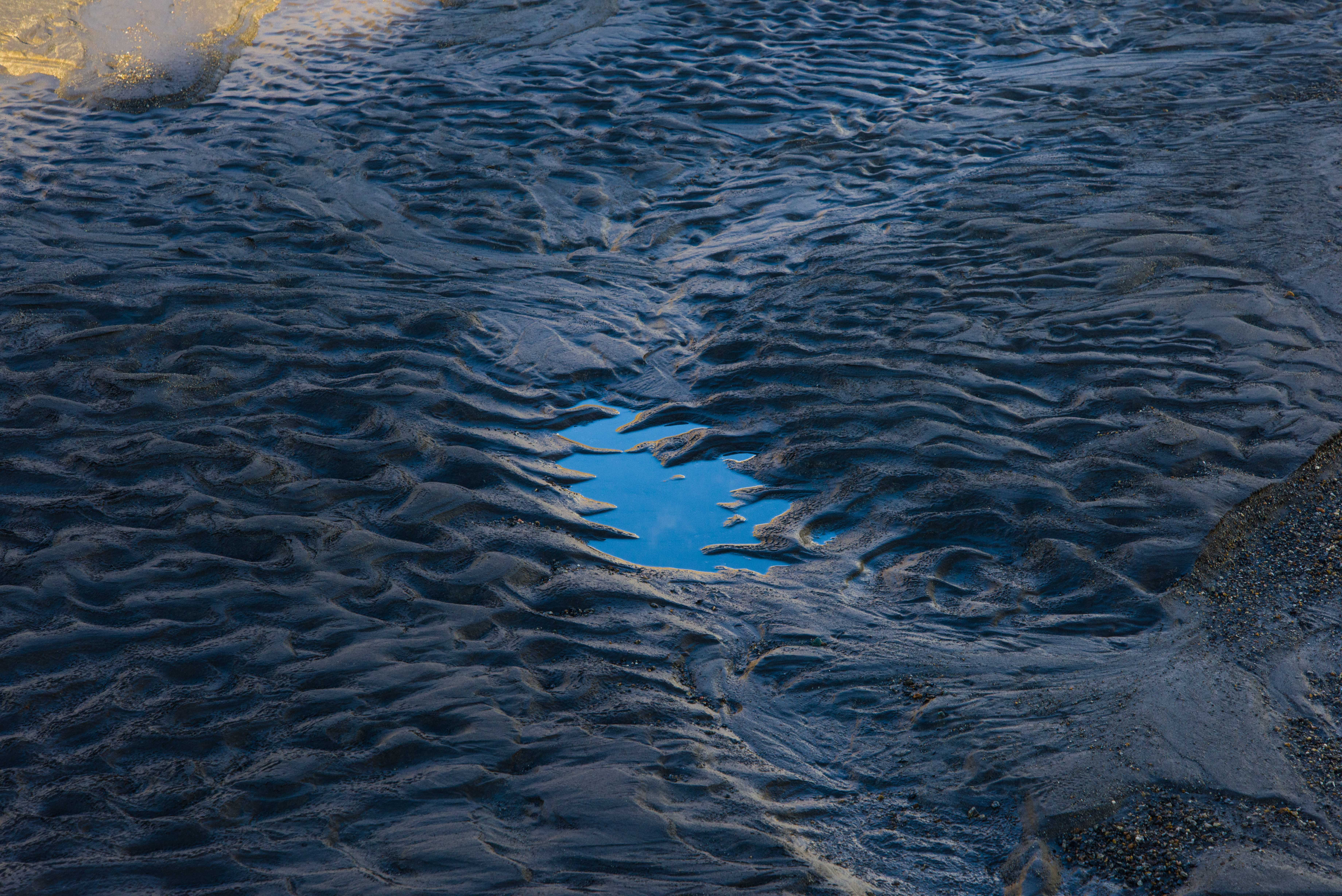
 2021-0927-114-ED.jpg
(2021) Every summer, the soupy mix of melted ice and fine glacial silt from the Greenland ice sheet settles in the fjord after passing beneath the town bridge. Here, as autumn arrives, the water level decreases, revealing semi-frozen mud — and quicksand. This photograph is part of the permanent installation at the Kangerlussuaq Museum.
-
 Glacial Silt, Kangerlussuaq FjordA close-up of the wave-like patterns of silt on the rocks where Qinnguata Kuussua (also known as Watson River) empties into the Kangerlussuaq Fjord after passing through a channel in the rock blasted by the American military, spanned by a bridge. The river is fed by melting of the Greenland ice cap flowing off the Russell Glacier, which in the summer months is milky with fine glacial silt. As one scientist puts it, "By the time it gets to Kangerlussuaq and passes under the town’s bridge, it’s essentially a rock, soil, and sand smoothie."
 -
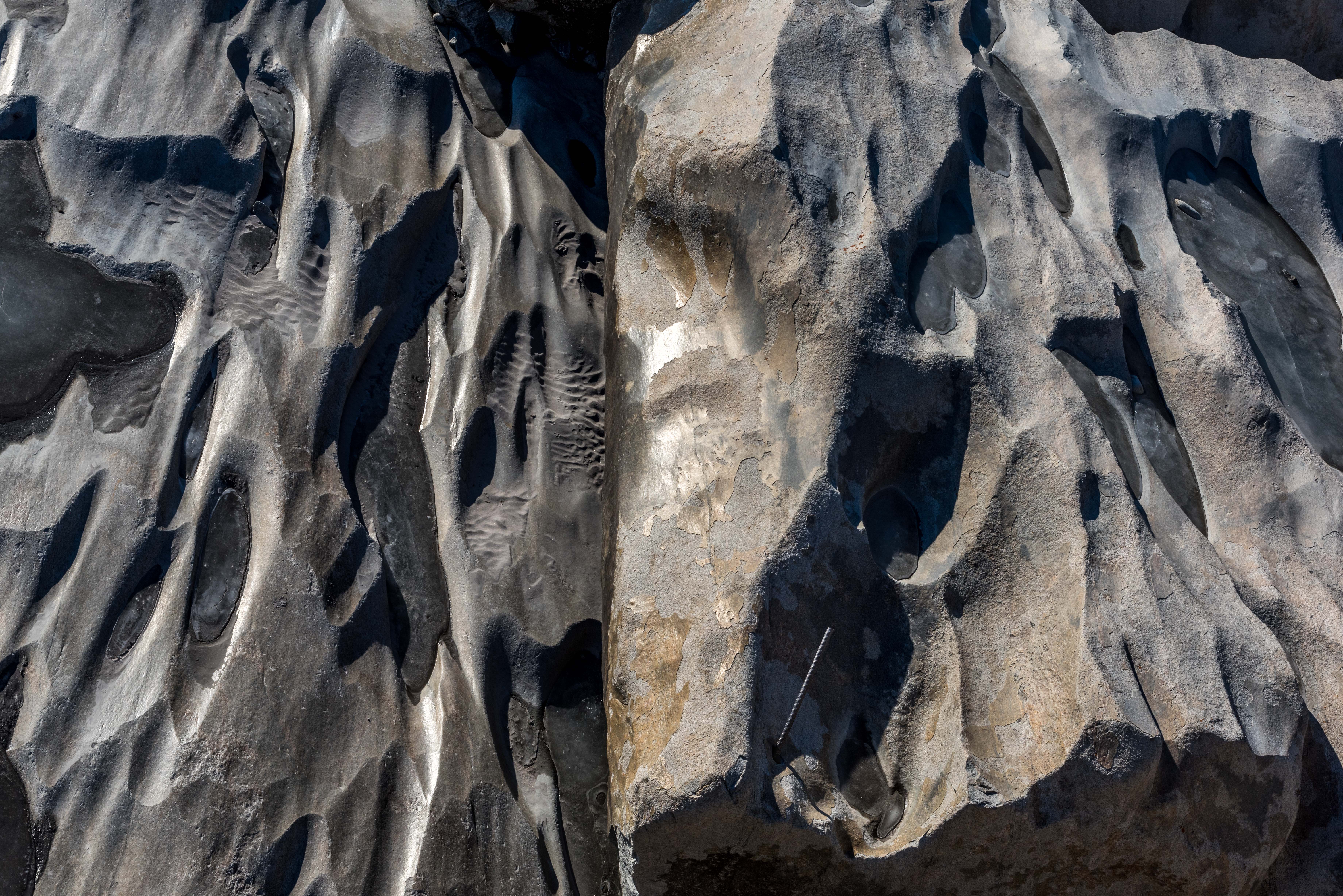
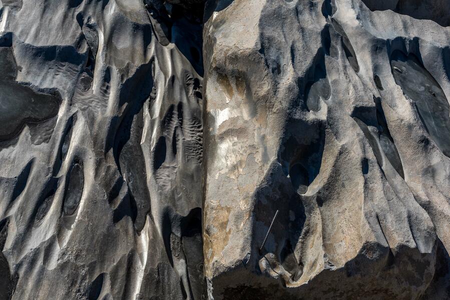 Rocks and Rebar, Kangerlussuaq Fjord(2021) Looking down on the eroded rocks beneath the bridge where the river flowing from the Greenland ice cap some 20 miles away empties into the fjord. A piece of rebar is embedded in the rock, possibly from one of the earlier bridges this one replaced.