About Graham

Graham Coreil-Allen (he/him) is a Baltimore-based public artist making places more inclusive and livable through public art, placemaking, and civic engagement. Coreil-Allen collaborates with neighbors to interpret and activate public space through placemaking projects for pedestrian safety and play. From traffic calming pavement art and participatory urban design to creative wayfinding and interactive sculptures, Coreil-Allen infuses public space with play… more
Festival Projects: SunStomp, Dancing Forest, & Choose Your Own Adventure
-
Sun Stomp Light City 2018
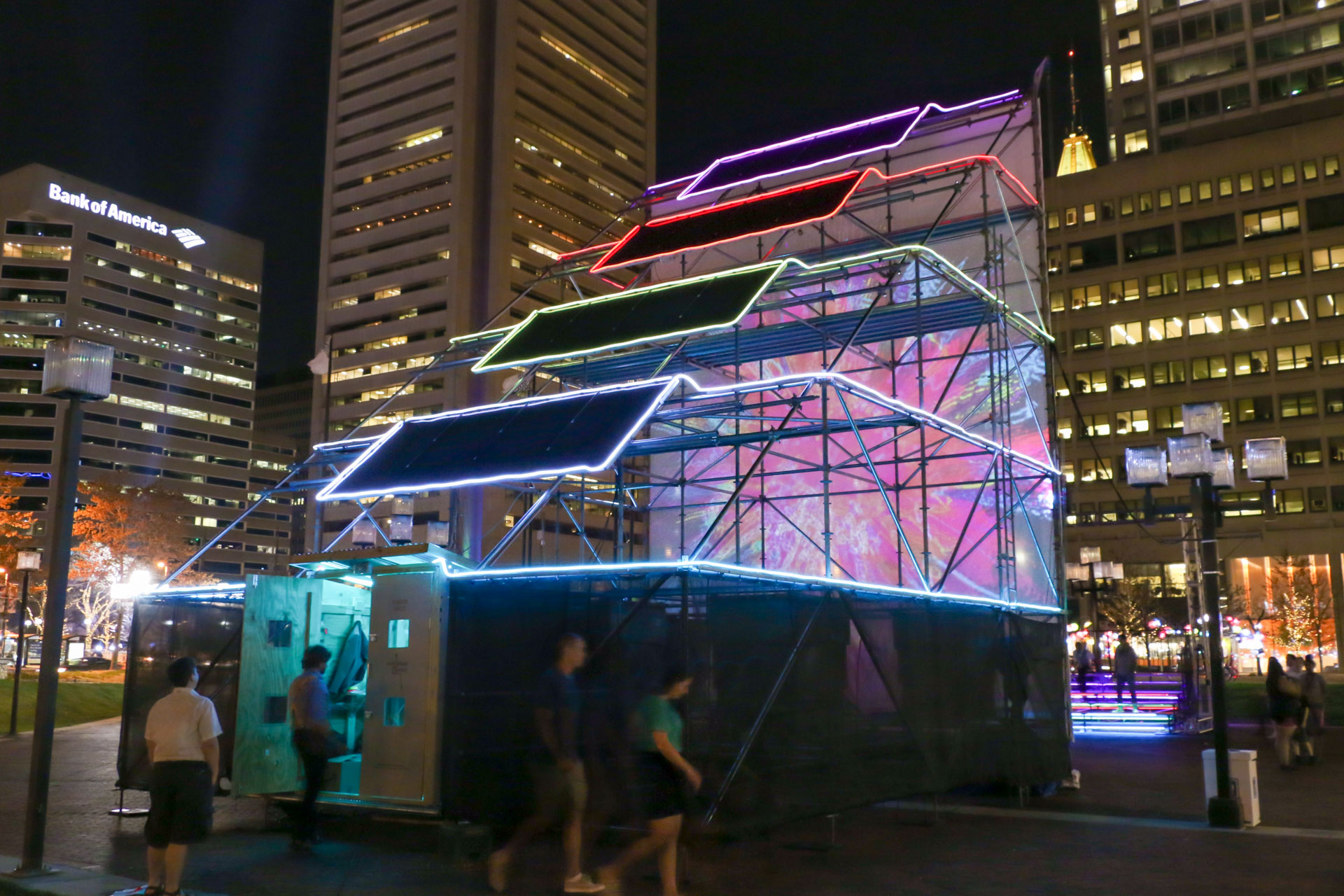
Sun Stomp was a solar powered light and interactive audio-visual environment that featured an interactive projection on one side and an array of sixteen 290 watt solar panels on the other. Participants were invited to stomp on the bleachers to trigger sun
-
 Sun StompSun Stomp was a solar powered light and interactive audio-visual environment that featured an interactive projection on one side and an array of sixteen 290 watt solar panels on the other. Participants were invited to stomp on the bleachers to trigger sun-inspired visuals and amplified sounds of the Sun. Sun Stomp April 14-21, 2018 Light City Baltimore, McKeldin Square, 101 E. Pratt Street, Baltimore, MD Scaffolding, bleachers, solar panels, solar hardware, projection screen, projector, LED neon, contact microphones, video processor 34’x24’x75’ Project partner: Baltimore Office of Promotion and the Arts
 -
 Sun Stomp - bleacher interactionSun Stomp was a solar powered light and interactive audio-visual environment that featured an interactive projection on one side and an array of sixteen 290 watt solar panels on the other. Participants were invited to stomp on the bleachers to trigger sun-inspired visuals and amplified sounds of the Sun. Sun Stomp April 14-21, 2018 Light City Baltimore, McKeldin Square, 101 E. Pratt Street, Baltimore, MD Scaffolding, bleachers, solar panels, solar hardware, projection screen, projector, LED neon, contact microphones, video processor 34’x24’x75’ Project partner: Baltimore Office of Promotion and the Arts
 -
 Sun Stomp - LED neon matrixSun Stomp was a solar powered light and interactive audio-visual environment that featured an interactive projection on one side and an array of sixteen 290 watt solar panels on the other. Participants were invited to stomp on the bleachers to trigger sun-inspired visuals and amplified sounds of the Sun. Sun Stomp April 14-21, 2018 Light City Baltimore, McKeldin Square, 101 E. Pratt Street, Baltimore, MD Scaffolding, bleachers, solar panels, solar hardware, projection screen, projector, LED neon, contact microphones, video processor 34’x24’x75’ Project partner: Baltimore Office of Promotion and the Arts
 -
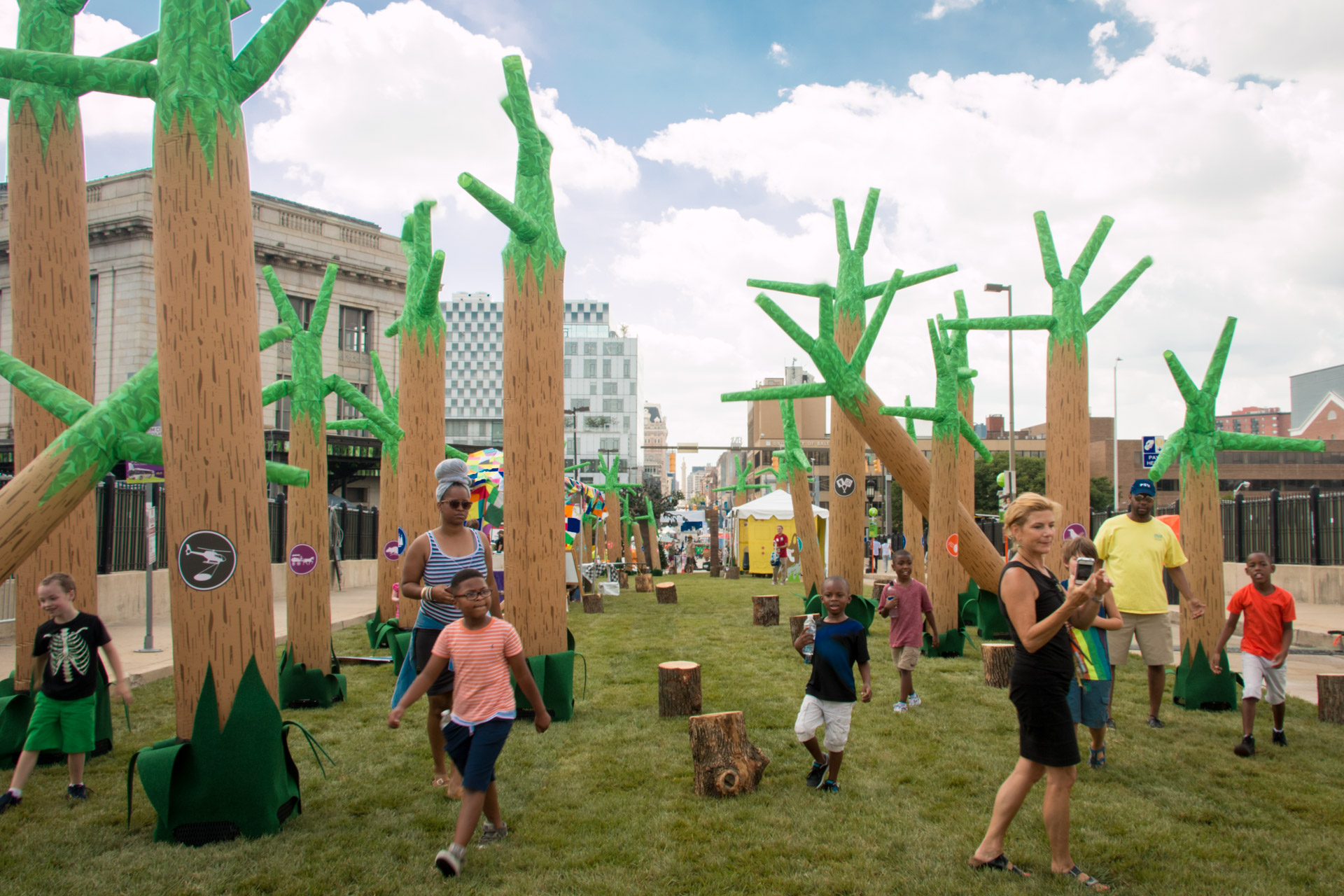
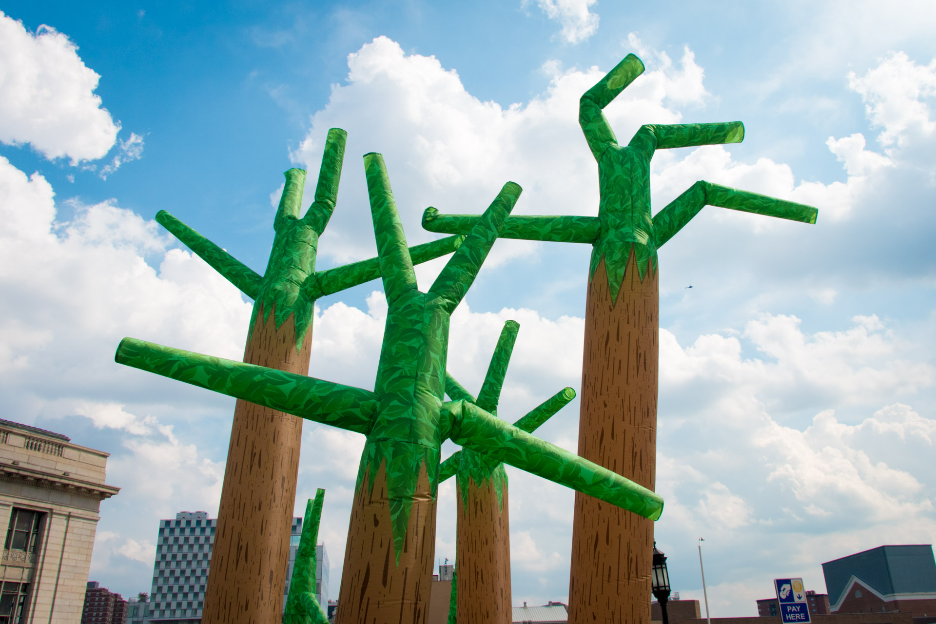
Dancing ForestAnchoring the 2017 Artscape Charles Street Trail July 21-23, Dancing Forest was a kinetic environment of inflatable trees emblazoned with trail markers identifying Baltimore’s many classic places, features, and customs. Participants were encouraged to walk among and explore the the animated trees as they undulated in the sky. Up close, one found an array of urban trail symbols, such as benches, snowballs, bikers, and buildings. Internal LED illumination of the sculptures allowed nighttime exploration. Combining spectacular movement with urban wayfinding symbols, Dancing Forest created an exciting, playful environment inspiring participants to continue exploring Baltimore’s many intriguing places. Dancing Forest July 21-23, 2017 Artscape Charles Street Bridge, Baltimore, MD Submersion printed nylon, blowers, felt, LED lights, grass, website 20’ x 45’ x 200’ Project partners: Baltimore Office of Promotion and the Arts, Station North Tool Library
-
 Dancing ForestAnchoring the 2017 Artscape Charles Street Trail July 21-23, Dancing Forest was a kinetic environment of inflatable trees emblazoned with trail markers identifying Baltimore’s many classic places, features, and customs. Participants were encouraged to walk among and explore the the animated trees as they undulated in the sky. Up close, one found an array of urban trail symbols, such as benches, snowballs, bikers, and buildings. Internal LED illumination of the sculptures allowed nighttime exploration. Combining spectacular movement with urban wayfinding symbols, Dancing Forest created an exciting, playful environment inspiring participants to continue exploring Baltimore’s many intriguing places. Dancing Forest July 21-23, 2017 Artscape Charles Street Bridge, Baltimore, MD Submersion printed nylon, blowers, felt, LED lights, grass, website 20’ x 45’ x 200’ Project partners: Baltimore Office of Promotion and the Arts, Station North Tool Library
 -
 Dancing Forest - detailAnchoring the 2017 Artscape Charles Street Trail July 21-23, Dancing Forest was a kinetic environment of inflatable trees emblazoned with trail markers identifying Baltimore’s many classic places, features, and customs. Participants were encouraged to walk among and explore the the animated trees as they undulated in the sky. Up close, one found an array of urban trail symbols, such as benches, snowballs, bikers, and buildings. Internal LED illumination of the sculptures allowed nighttime exploration. Combining spectacular movement with urban wayfinding symbols, Dancing Forest created an exciting, playful environment inspiring participants to continue exploring Baltimore’s many intriguing places. Dancing Forest July 21-23, 2017 Artscape Charles Street Bridge, Baltimore, MD Submersion printed nylon, blowers, felt, LED lights, grass, website 20’ x 45’ x 200’ Project partners: Baltimore Office of Promotion and the Arts, Station North Tool Library
 -
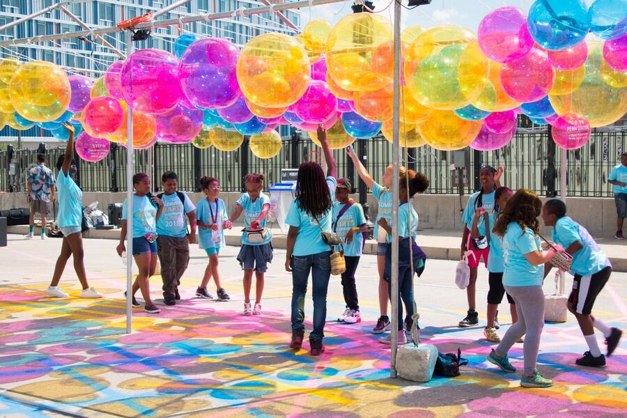
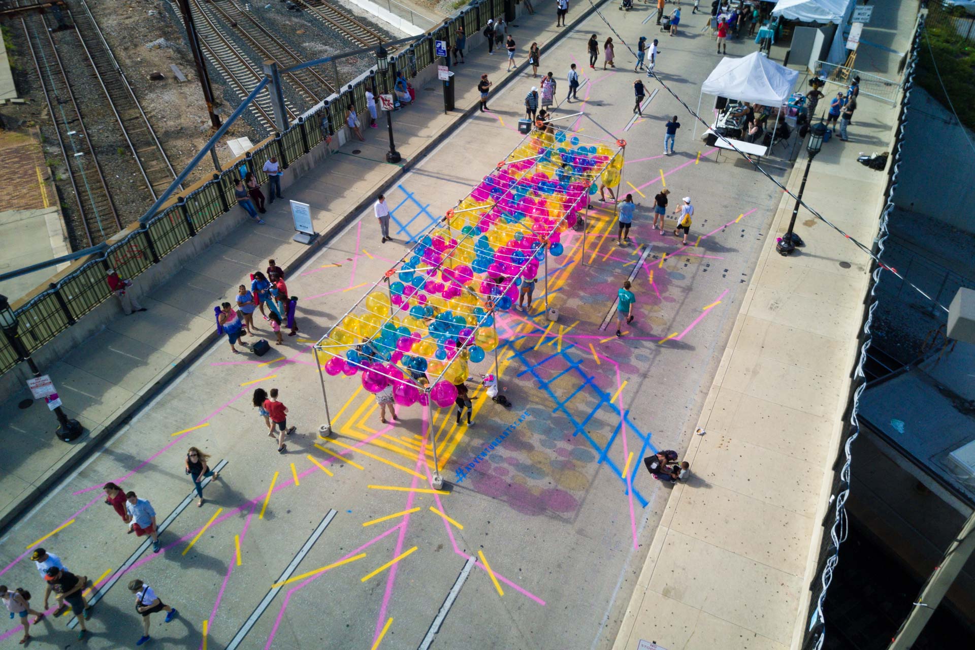
Choose Your Own AdventureMade in collaboration with Becky Borlan, Choose your own Adventure transformed Baltimore’s Charles Street Bridge into a colorful playscape of pedestrian pathways and hanging beach balls. The project was commissioned by Baltimore Office of Promotion and the Arts for the free 2018 Artscape festival. Spray chalk lines marked a site-based map converging under a forest of beach balls hanging from an open air structure. Choose Your Own Adventure July 20-22, 2018 Charles Street Bridge at Penn Station, Artscape, Baltimore, MD Beach balls, line striping paint, tent structure, LED lights, poetry 12’x40’x100’ Project partner: Baltimore Office of Promotion and the Arts
-
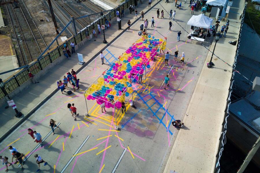 Choose Your Own AdventureMade in collaboration with Becky Borlan, Choose your own Adventure transformed Baltimore’s Charles Street Bridge into a colorful playscape of pedestrian pathways and hanging beach balls. The project was commissioned by Baltimore Office of Promotion and the Arts for the free 2018 Artscape festival. Spray chalk lines marked a site-based map converging under a forest of beach balls hanging from an open air structure. Choose Your Own Adventure July 20-22, 2018 Charles Street Bridge at Penn Station, Artscape, Baltimore, MD Beach balls, line striping paint, tent structure, LED lights, poetry 12’x40’x100’ Project partner: Baltimore Office of Promotion and the Arts Photo by Baltimore Aerials https://www.baltimoreaerialproductions.com/
 -
 Choose Your Own AdventureMade in collaboration with Becky Borlan, Choose your own Adventure transformed Baltimore’s Charles Street Bridge into a colorful playscape of pedestrian pathways and hanging beach balls. The project was commissioned by Baltimore Office of Promotion and the Arts for the free 2018 Artscape festival. Spray chalk lines marked a site-based map converging under a forest of beach balls hanging from an open air structure. Choose Your Own Adventure July 20-22, 2018 Charles Street Bridge at Penn Station, Artscape, Baltimore, MD Beach balls, line striping paint, tent structure, LED lights, poetry 12’x40’x100’ Project partner: Baltimore Office of Promotion and the Arts


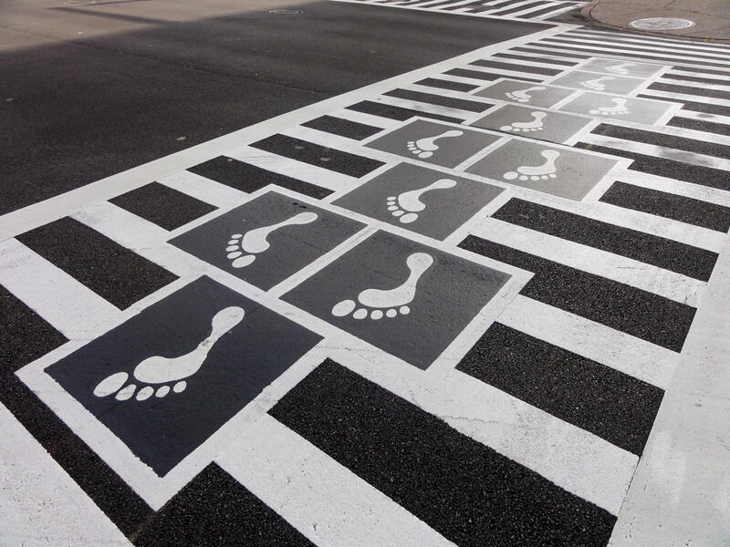
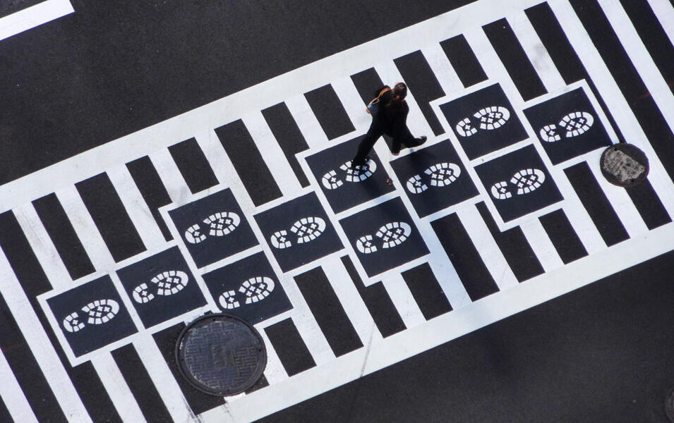
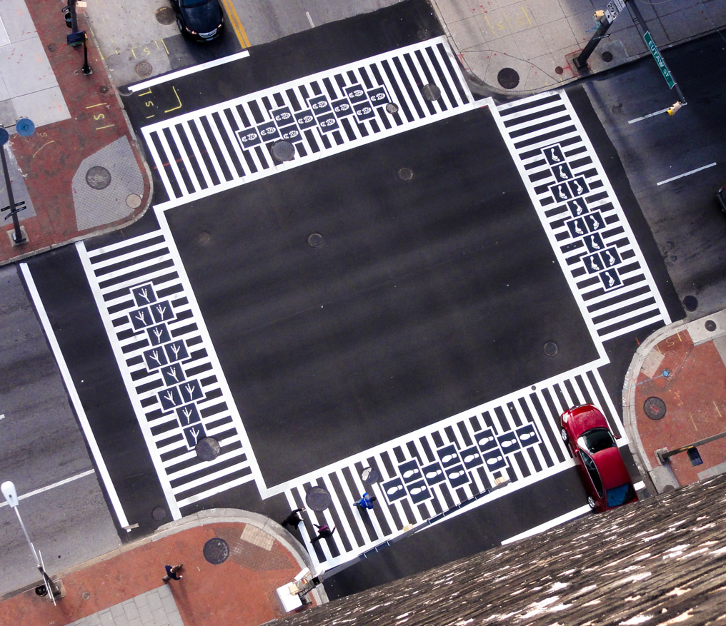
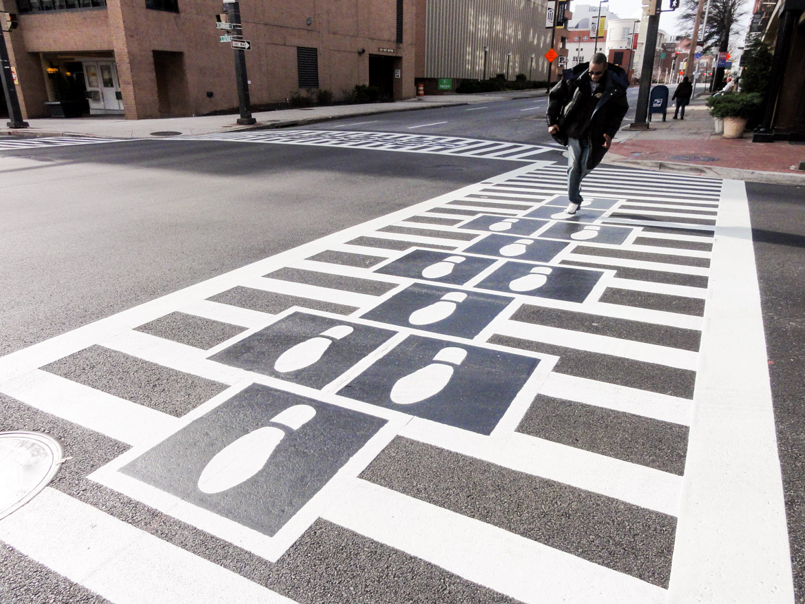
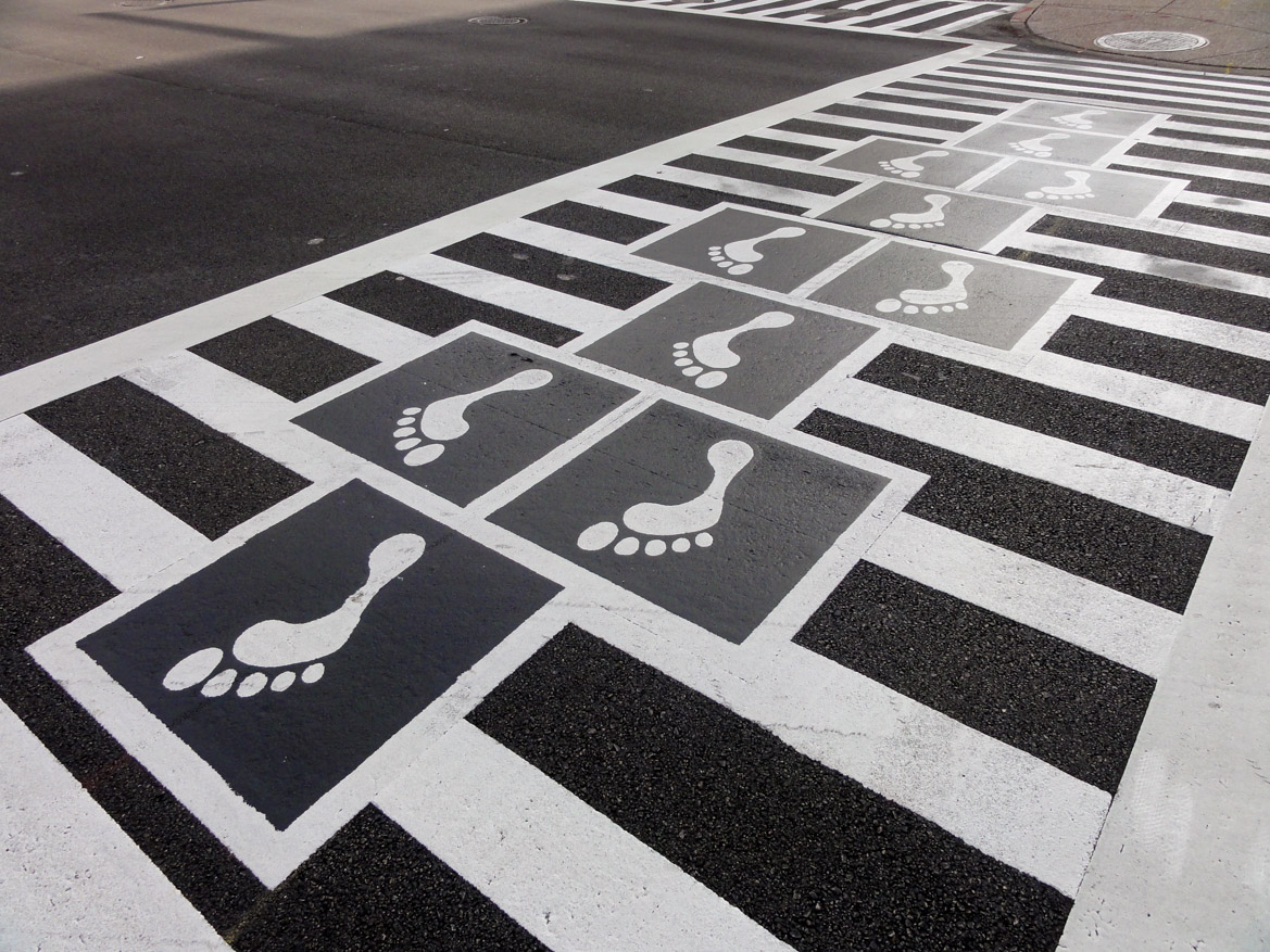
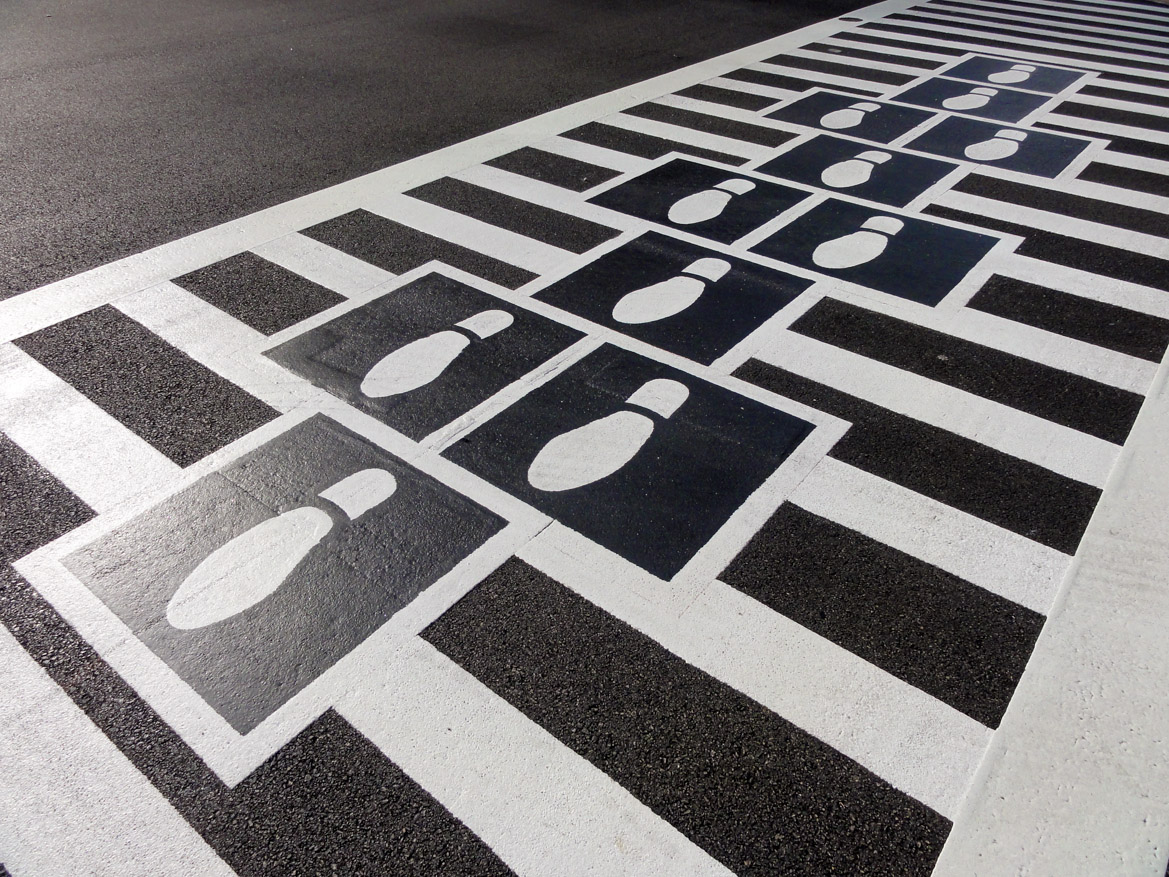
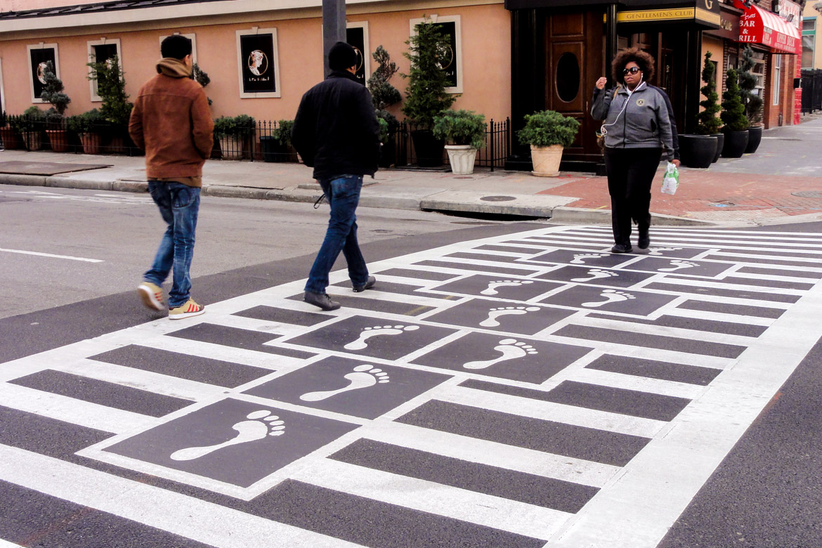
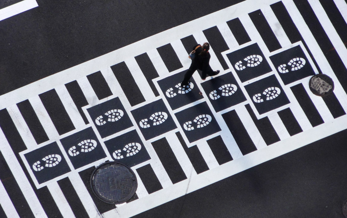
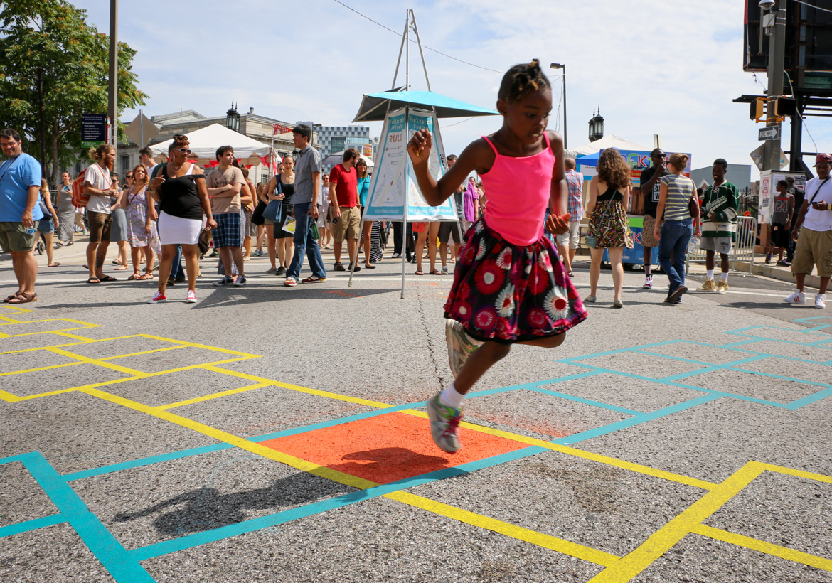
Hopscotch Crosswalk Colossus
-
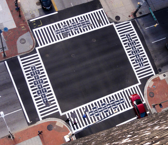 Hopscotch Crosswalk Colossus - overhead view
 -
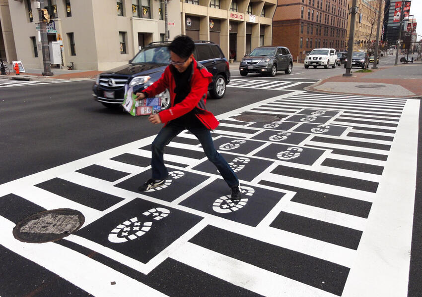
 Hopscotch Crosswalk Colossus - business man jumping shoe prints
 -
 Hopscotch Crosswalk Colossus - man jumping
 -
 Hopscotch Crosswalk Colossus - foot prints
 -
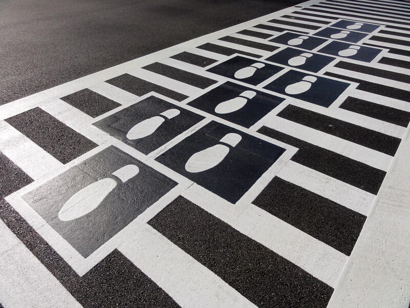 Hopscotch Crosswalk Colossus - shoe prints
 -
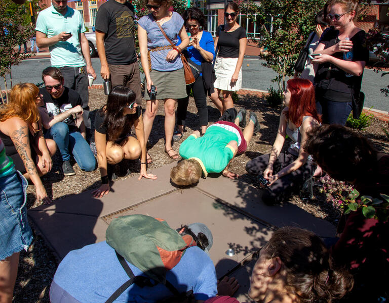
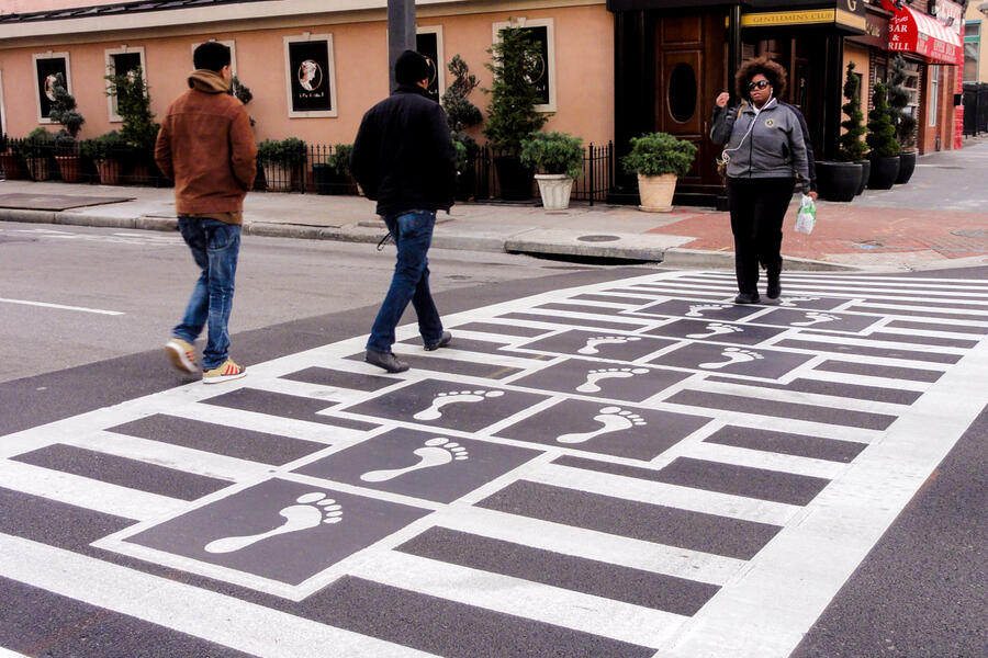 Hopscotch Crosswalk Colossus - people crossing
 -
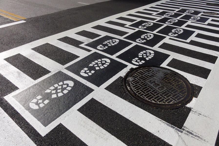 Hopscotch Crosswalk Colossus - boot prints
 -
 Hopscotch Crosswalk Colossus - boot prints from above
 -
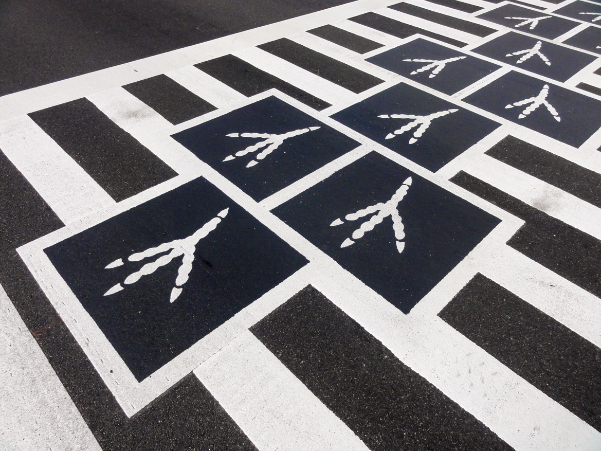
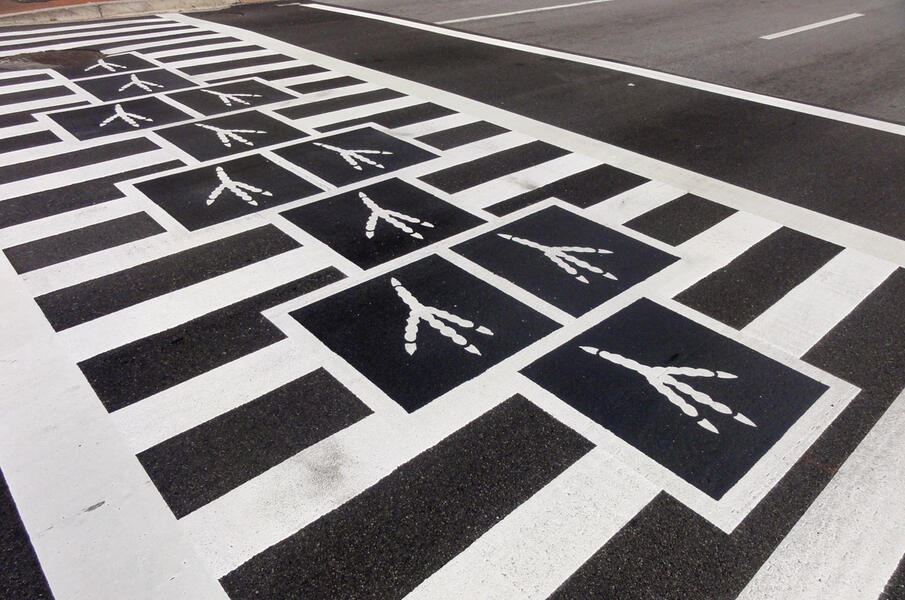 Hopscotch Crosswalk Colossus - bird tracks
 -
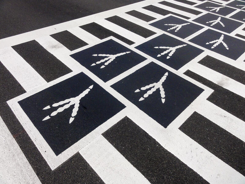 Hopscotch Crosswalk Colossus - bird tracks detail


Participatory Mapping
-
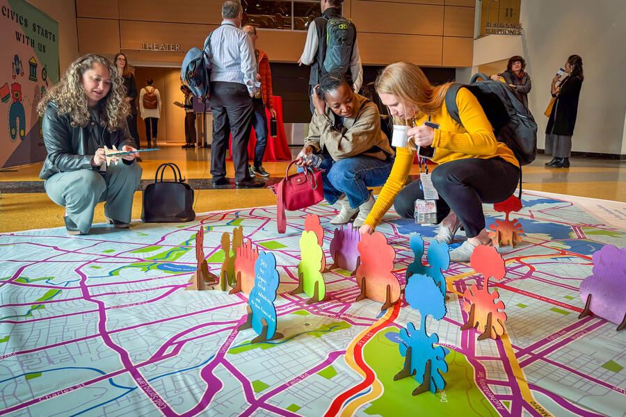
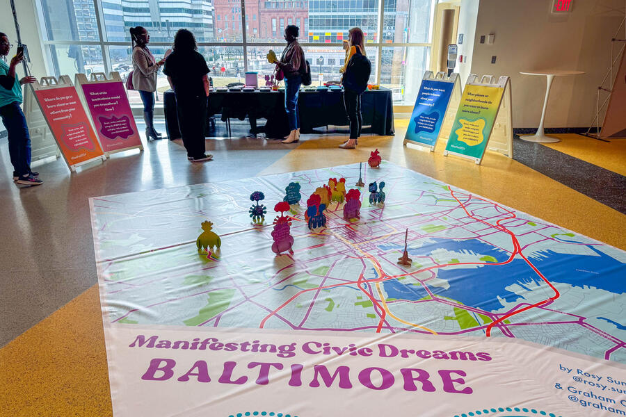
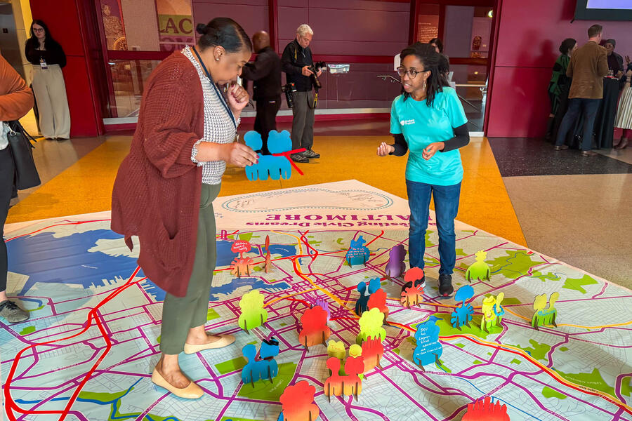 Manifesting Civic Dreams: Baltimore
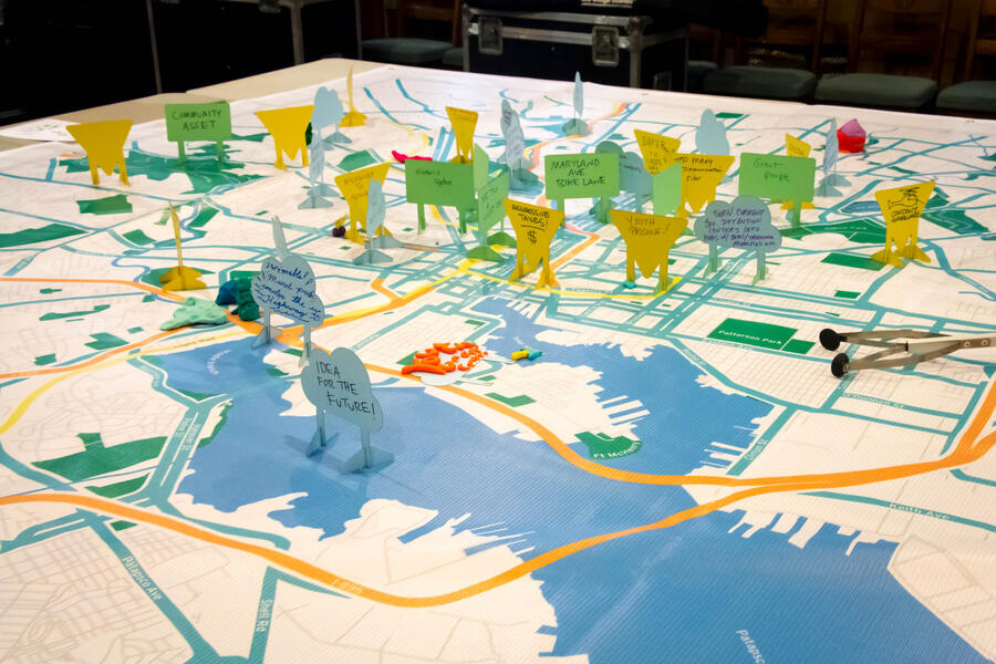
For the Johns Hopkins University SNF Agora Institute’s annual Elijah E. Cummings Democracy and Freedom Festival, artists Graham Coreil-Allen and Rosy Sunshine Galván created Manifesting Civic Dreams: Baltimore, a large, interactive floor map for participants to reflect on their personal and collective challenges, neighborhood treasures, and visionary possibilities of Baltimore City. The installation featured a colorful, 12’ x 15’ printed floor map to which residents added their own stories, neighborhood assets, challenges, and ideas by writing and drawing on custom laser cut pop-up cardboard signs and then placing them on the map.
-
 Manifesting Civic Dreams: Baltimore
For the Johns Hopkins University SNF Agora Institute’s annual Elijah E. Cummings Democracy and Freedom Festival, artists Graham Coreil-Allen and Rosy Sunshine Galván created Manifesting Civic Dreams: Baltimore, a large, interactive floor map for participants to reflect on their personal and collective challenges, neighborhood treasures, and visionary possibilities of Baltimore City. The installation featured a colorful, 12’ x 15’ printed floor map to which residents added their own stories, neighborhood assets, challenges, and ideas by writing and drawing on custom laser cut pop-up cardboard signs and then placing them on the map.
-
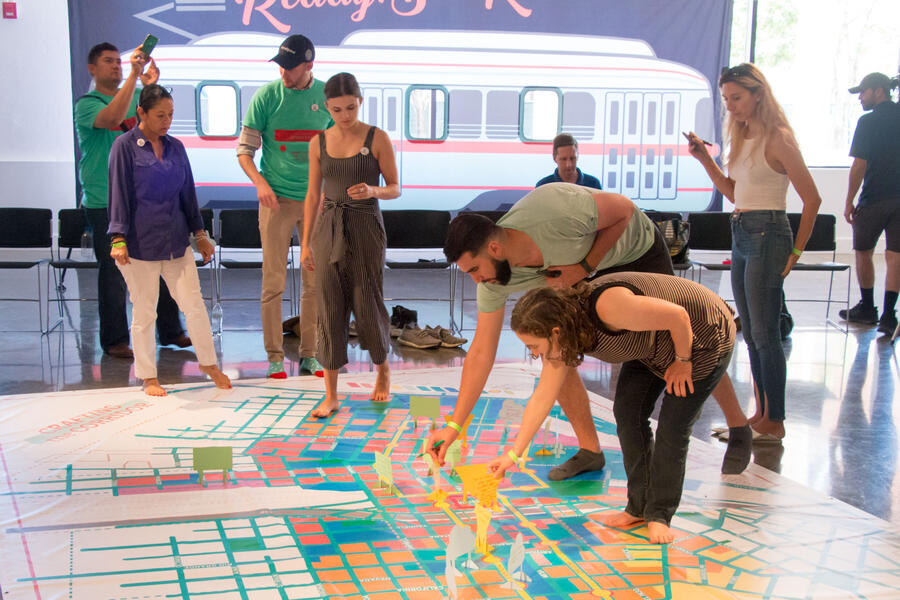 El Paso Crafting the Corridor participationThrough the Crafting the Corridor community tour and interactive mapping workshop, El Paso residents, business owners, planners, and elected officials shared personal perspectives and identified local assets, challenges, and ideas for strengthening their neighborhoods along the city’s new streetcar routes. City planners documented participants’ numerous contributions as input for the El Paso Streetcar Corridor Plan. Crafting the Corridor October 6, 2018 El Paso Museum of Art, El Paso, TX Color vinyl banner, laser cut pop-up signs, play doh, tape, markers 10’x20’ Project partners: Planning & Inspections Department of the City of El Paso, Offices of El Paso City Council Representatives Peter Svarzbein and Cissy Lizarraga
 -
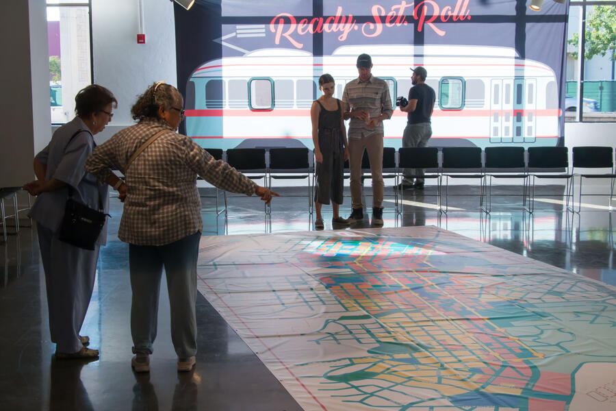 El Paso Crafting the Corridor gatheringThrough the Crafting the Corridor community tour and interactive mapping workshop, El Paso residents, business owners, planners, and elected officials shared personal perspectives and identified local assets, challenges, and ideas for strengthening their neighborhoods along the city’s new streetcar routes. City planners documented participants’ numerous contributions as input for the El Paso Streetcar Corridor Plan. Crafting the Corridor October 6, 2018 El Paso Museum of Art, El Paso, TX Color vinyl banner, laser cut pop-up signs, play doh, tape, markers 10’x20’ Project partners: Planning & Inspections Department of the City of El Paso, Offices of El Paso City Council Representatives Peter Svarzbein and Cissy Lizarraga
 -
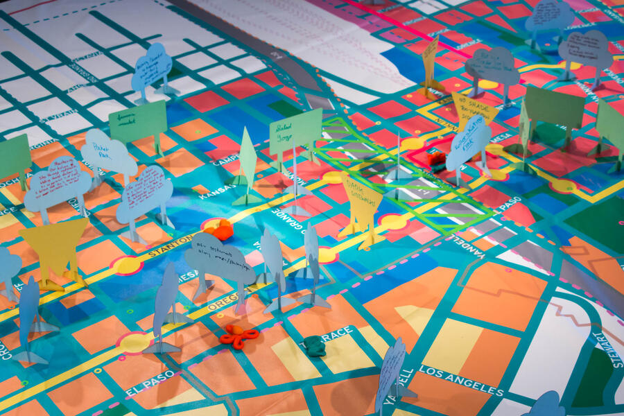 El Paso Crafting the Corridor signsThrough the Crafting the Corridor community tour and interactive mapping workshop, El Paso residents, business owners, planners, and elected officials shared personal perspectives and identified local assets, challenges, and ideas for strengthening their neighborhoods along the city’s new streetcar routes. City planners documented participants’ numerous contributions as input for the El Paso Streetcar Corridor Plan. Crafting the Corridor October 6, 2018 El Paso Museum of Art, El Paso, TX Color vinyl banner, laser cut pop-up signs, play doh, tape, markers 10’x20’ Project partners: Planning & Inspections Department of the City of El Paso, Offices of El Paso City Council Representatives Peter Svarzbein and Cissy Lizarraga
 -
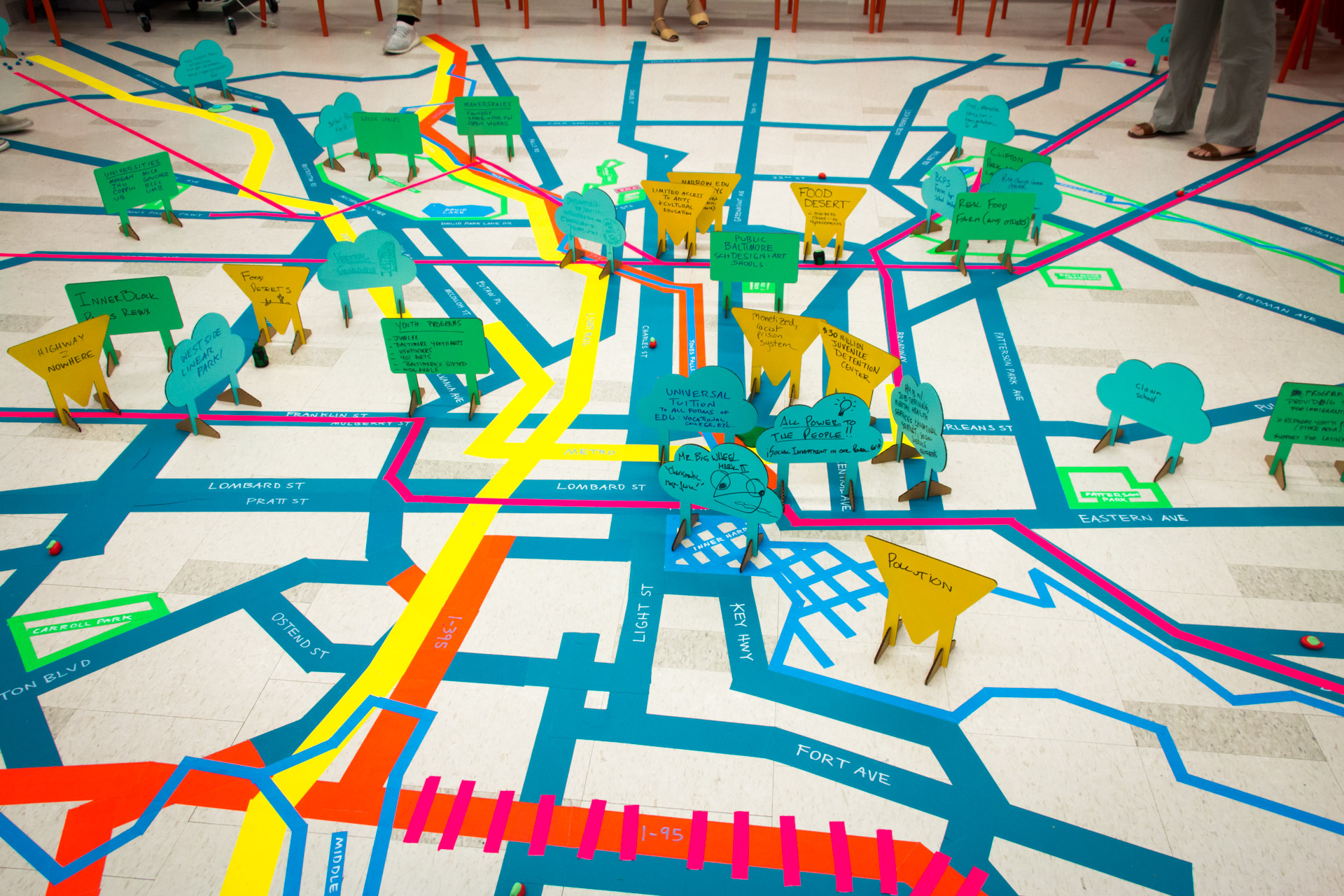
 Visioning Home Mapping - afterVisioning Home was a day-long workshop at the Baltimore Museum of Art that invited participants to challenge the entrenched narratives about Baltimore neighborhoods and envision possible futures. As part of the Imagining Home exhibit series, forty residents from across the city gathered for this meaningful day to learn about civically engaged art, find inspiration in the museum’s collection, and take part in a series of facilitated conversations and artmaking activities designed to spark creative thinking about changes and opportunities in Baltimore. The day of engagement culminated in an interactive mapping installation and activity created and led by public artist Graham Coreil-Allen. Participants used laser cut cardboard signs to write and illustrate their neighborhood assets, challenges, and new ideas. They placed these signs on corresponding locations within an immersive, 22’ x 24’ floor map made of brightly colored tape. Residents highlighted and sensitively discussed a range of issues such as the school-to-prison pipeline, food deserts, and industrial pollution; and proposed new ideas such as job-creating urban farms, universal tuition, and completing Baltimore’s mass transit rail network.
 -
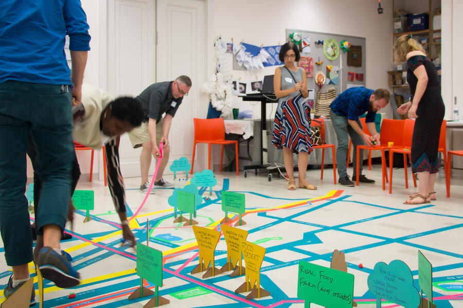 Visioning Home Mapping - participants laying tapeVisioning Home was a day-long workshop at the Baltimore Museum of Art that invited participants to challenge the entrenched narratives about Baltimore neighborhoods and envision possible futures. As part of the Imagining Home exhibit series, forty residents from across the city gathered for this meaningful day to learn about civically engaged art, find inspiration in the museum’s collection, and take part in a series of facilitated conversations and artmaking activities designed to spark creative thinking about changes and opportunities in Baltimore. The day of engagement culminated in an interactive mapping installation and activity created and led by public artist Graham Coreil-Allen. Participants used laser cut cardboard signs to write and illustrate their neighborhood assets, challenges, and new ideas. They placed these signs on corresponding locations within an immersive, 22’ x 24’ floor map made of brightly colored tape. Residents highlighted and sensitively discussed a range of issues such as the school-to-prison pipeline, food deserts, and industrial pollution; and proposed new ideas such as job-creating urban farms, universal tuition, and completing Baltimore’s mass transit rail network.
 -
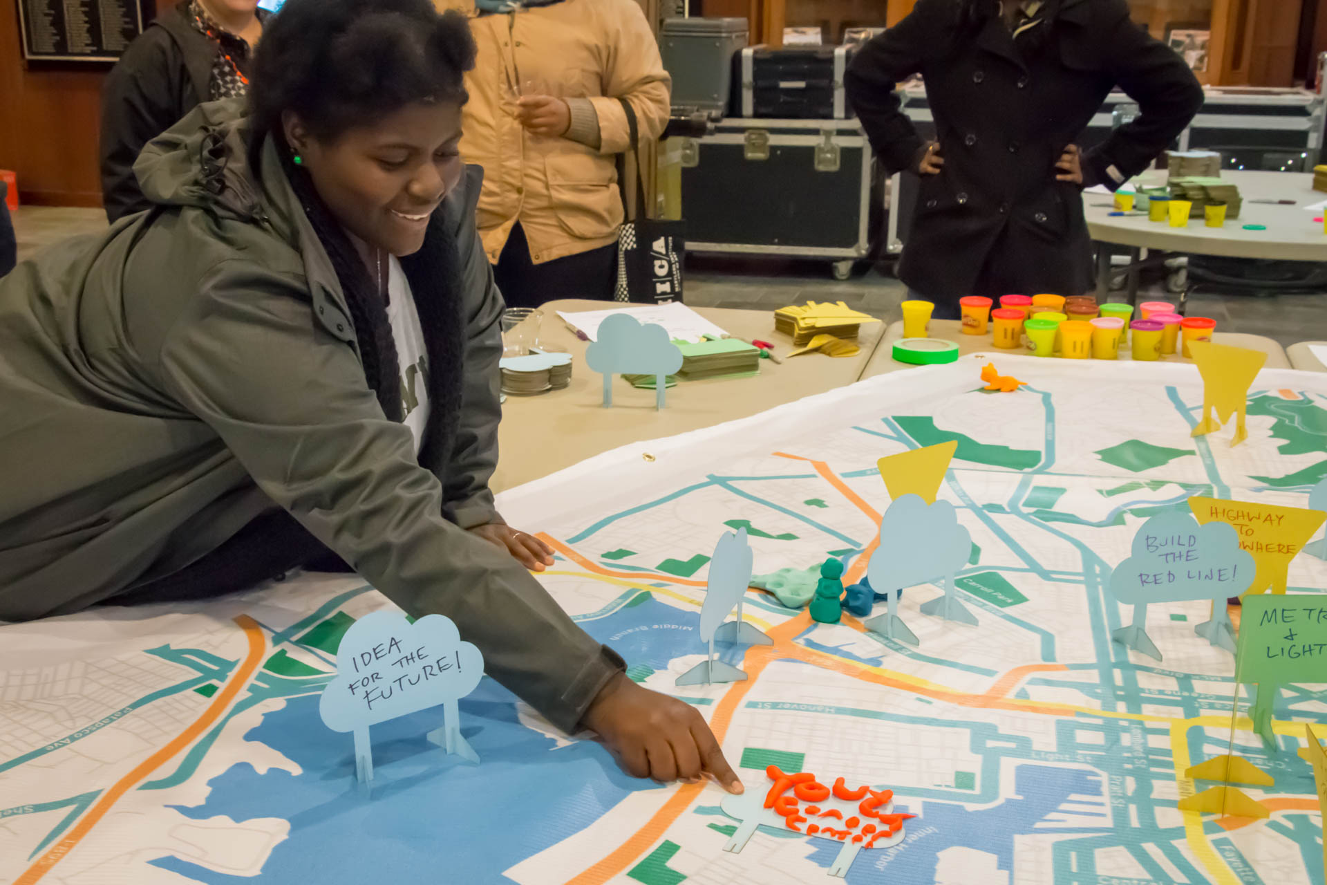
 FutureSite Baltimore - youth adding signPresented by the Baltimore Museum of Art at Union Baptist Church, FutureSite Baltimore invited participants to challenge the entrenched narratives about our city and envision possible futures by sharing their neighborhood assets, concerns, and ideas. This interactive mapping activity was presented as part of the The Necessity of Tomorrow(s) lecture series featuring luminary artist Mark Bradford in conversation with BMA Director Christopher Bedford. Bradford’s talk explored how the artist grapples with “making a path,” and other key questions in his artistic practice and community-based work. Afterwards, attendees were invited to contribute to the FutureSite Baltimore map by writing on laser cut signs and creating play doh sculptures representing their inspired visions for the future of Baltimore City. Contributions to the map were collected by the museum to inform forthcoming programming. FutureSite Mapping Baltimore at the The Necessity of Tomorrow(s): Mark Bradford—Making a Path Saturday, November 11, 2017, 12pm-3:30pm Presented by the Baltimore Museum of Art at Union Baptist Church, Baltimore, MD Partners: The Baltimore Museum of Art, Union Baptist Church
 -
 FutureSite Baltimore - Map with signsPresented by the Baltimore Museum of Art at Union Baptist Church, FutureSite Baltimore invited participants to challenge the entrenched narratives about our city and envision possible futures by sharing their neighborhood assets, concerns, and ideas. This interactive mapping activity was presented as part of the The Necessity of Tomorrow(s) lecture series featuring luminary artist Mark Bradford in conversation with BMA Director Christopher Bedford. Bradford’s talk explored how the artist grapples with “making a path,” and other key questions in his artistic practice and community-based work. Afterwards, attendees were invited to contribute to the FutureSite Baltimore map by writing on laser cut signs and creating play doh sculptures representing their inspired visions for the future of Baltimore City. Contributions to the map were collected by the museum to inform forthcoming programming. FutureSite Mapping Baltimore at the The Necessity of Tomorrow(s): Mark Bradford—Making a Path Saturday, November 11, 2017, 12pm-3:30pm Presented by the Baltimore Museum of Art at Union Baptist Church, Baltimore, MD Partners: The Baltimore Museum of Art, Union Baptist Church


Pop-Up Crosswalks & Pedestrian Playscapes
-
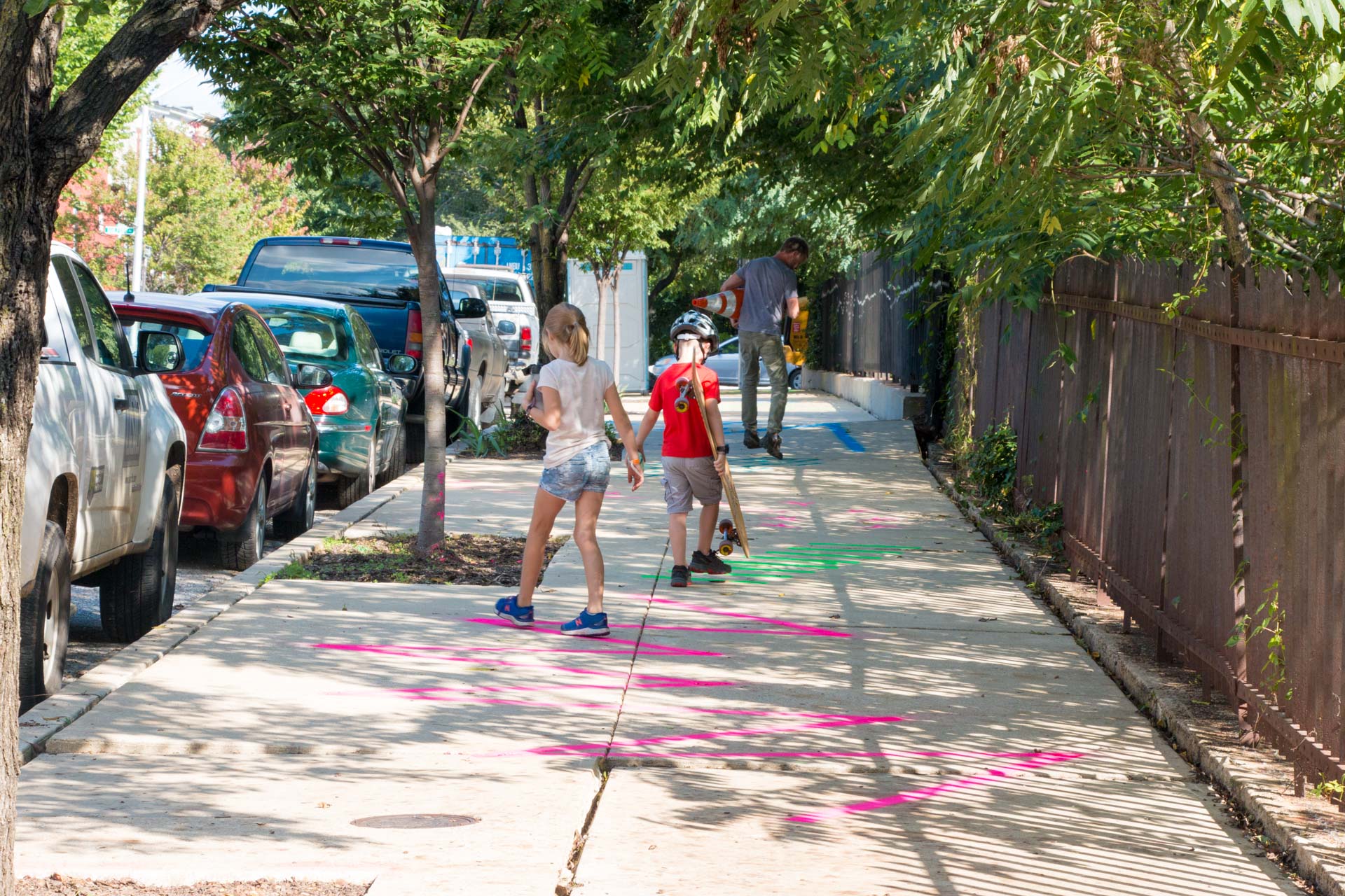
 26th St Agility TrailThe 26th Street Agility Trail consisted of a colorful array of foot-based games stenciled on the sidewalk for kids to play while walking to the nearby Margaret Brent Elementary and Middle School. Around the corner, the Guildford Bridge Vista Bench provides residents with a place to sit and watch trains going by in the tunnel below. 26th Street Agility Trail and Vista Bench September 2018 200 Block of 26th Street, Baltimore, MD Aerosol traffic paint, bench 400’x12’ Project partners: Harwood Community Association, Central Baltimore Partnership
 -
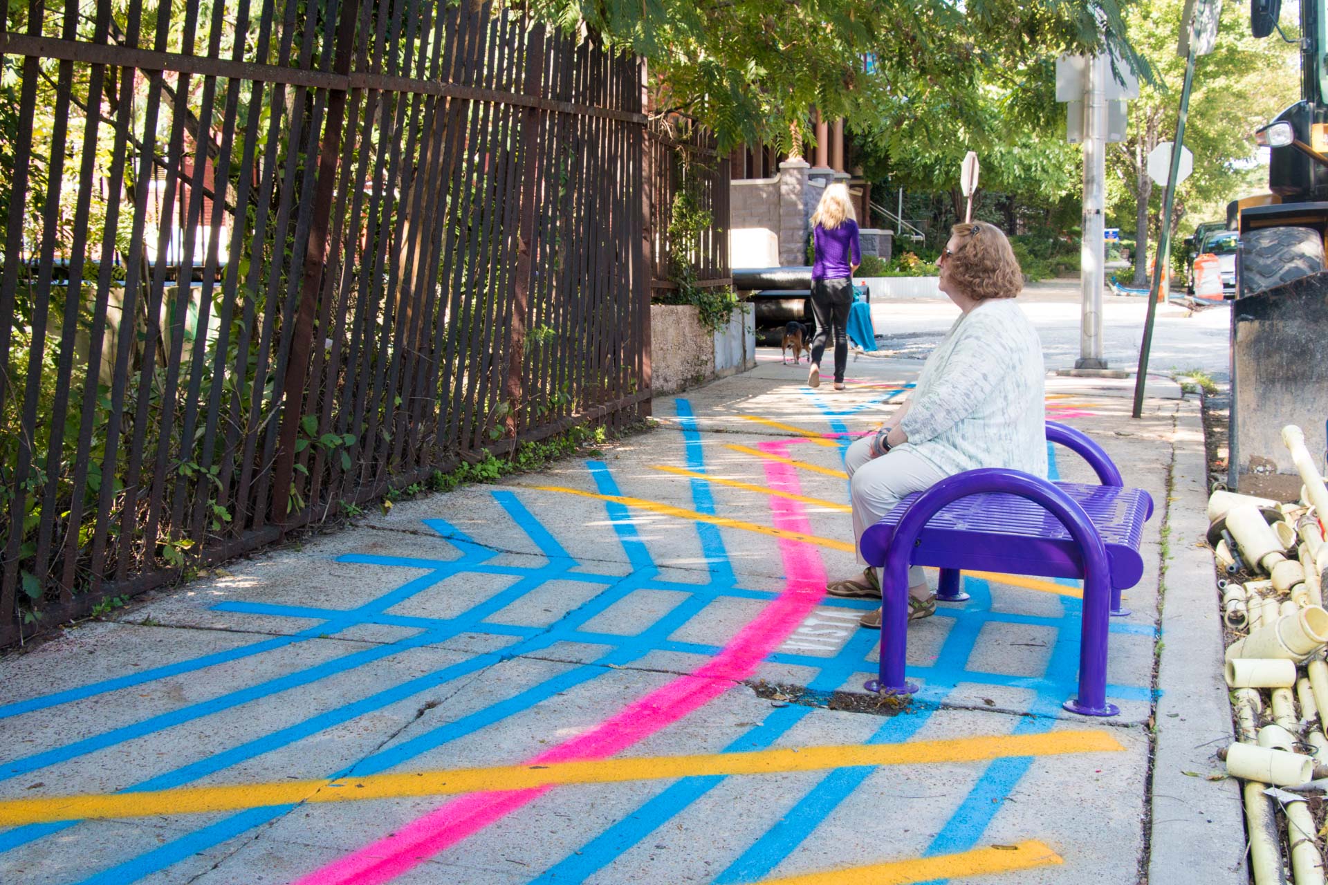
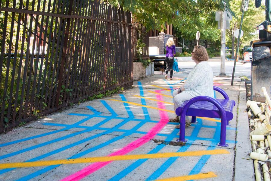 Guilford Bridge Vista BenchThe 26th Street Agility Trail consisted of a colorful array of foot-based games stenciled on the sidewalk for kids to play while walking to the nearby Margaret Brent Elementary and Middle School. Around the corner, the Guildford Bridge Vista Bench provides residents with a place to sit and watch trains going by in the tunnel below. 26th Street Agility Trail and Vista Bench September 2018 200 Block of 26th Street, Baltimore, MD Aerosol traffic paint, bench 400’x12’ Project partners: Harwood Community Association, Central Baltimore Partnership
 -
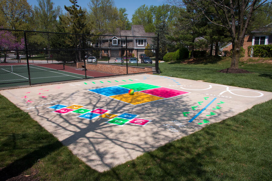 Greene Tree Agility TrailThe Greene Tree Agility Trail is an interactive playscape for younger children to engage their neighborhood public space through physical games and exercises. The project was commissioned by the Greene Tree Homeowners Association as a way to activate a disused former basketball court. The five color installation was made using a combination of stencil-based and hand painting techniques. The agility trail features an array of playful activities, including tip toe, jump, hop, hopscotch, side step, balance, and foursquare. Greene Tree Agility Trail April 2017 Greene Tree community, Pikesville, MD
 -
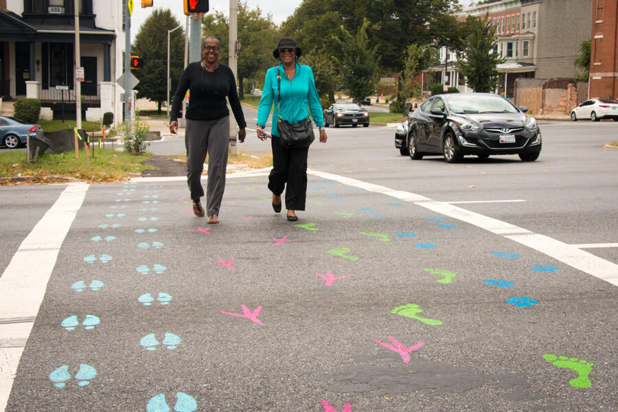
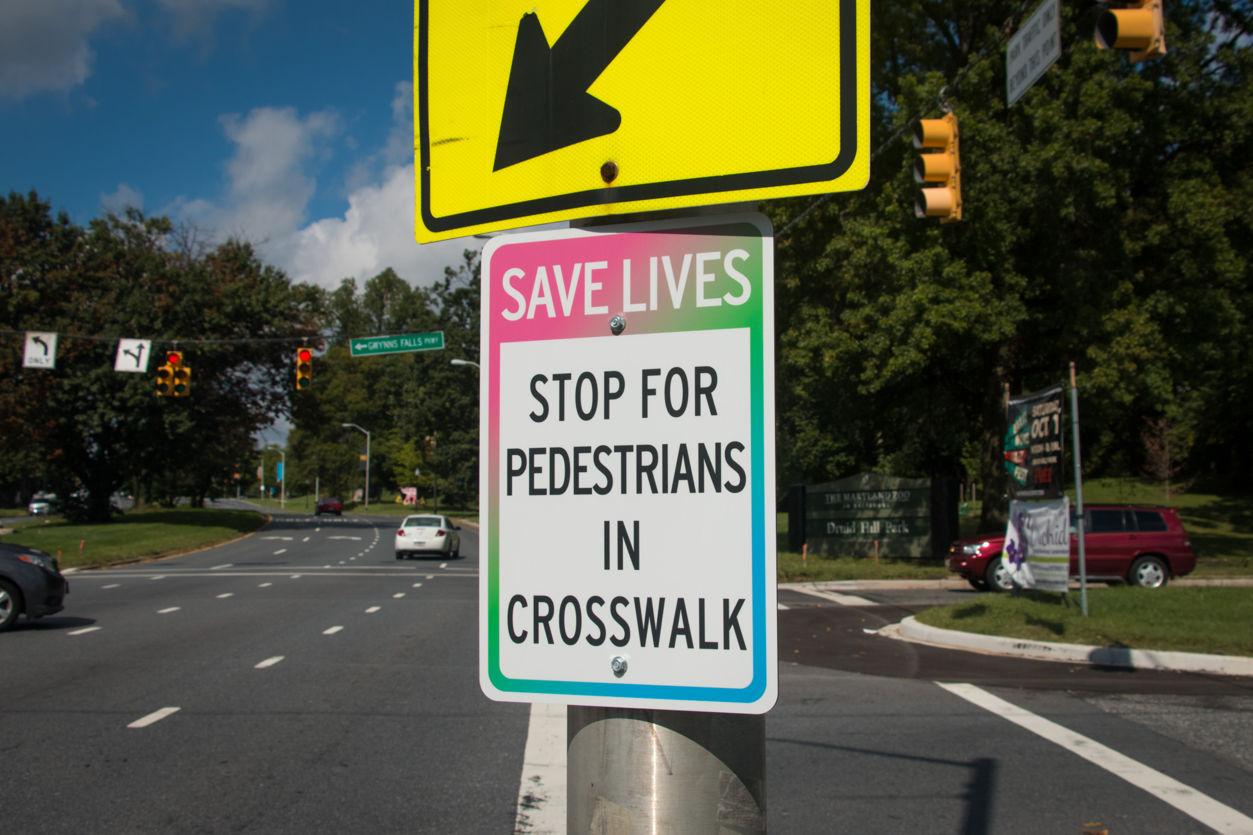
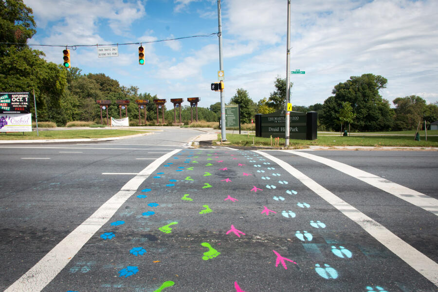 Footprints CrosswalkFootprints Crosswalk was a temporary crosswalk made of colorful stencils marking various walking tracks connecting the residents of Baltimore’s Auchentoroly Terrace neighborhood to the adjacent Druid Hill Park. The installation location was selected by residents through a Plan4Health-funded engagement process led by the Rails-to-Trails Conservancy and BikeMore in collaboration with the Auchentoroly Terrace Association and public artist Graham Coreil-Allen. Including foot, hoof, bird, and paw prints, the playful tracks of Footprints Crosswalk allude to both people and other creatures that frequent Druid Hill Park. The crosswalk is enhanced with "Save Lives" street signs hung all around the intersection that draw attention to the pedestrians’ rights-of-way. The west side of Druid Hill Park is cut off from the neighborhood by Auchentoroly Terrace, a former three lane boulevard turned into an eight lane highway during Baltimore’s 1960s era of destructive, car-oriented urban planning. Most residents in the area do not own cars, so the lack of safe crosswalks along the thoroughfare is a major hinderance to connecting with an otherwise beautiful space for urban recreation and exercise. Rails-to-Trails and BikeMore invited input during community meetings in and around the Druid Hill Farmers Market. For these meetings, resident and public artist Coreil-Allen made reusable whiteboard maps for participants to mark which intersections needed the most attention. Based on this input, the intersection of Auchentoroly Terrace and Gwynns Falls Parkway was selected as the best place to create a temporary project highlighting the need for increased pedestrian safety and connectivity. Footprints Crosswalk September 28, 2016 - October 2016 Auchentoroly Terrace & Gwynns Falls Parkway, Baltimore, MD
 -
 Footprints Crosswalk Save LivesFootprints Crosswalk was a temporary crosswalk made of colorful stencils marking various walking tracks connecting the residents of Baltimore’s Auchentoroly Terrace neighborhood to the adjacent Druid Hill Park. The crosswalk was enhanced with custom "Save Lives" street signs warning motorists to yield to pedestrians.
 -
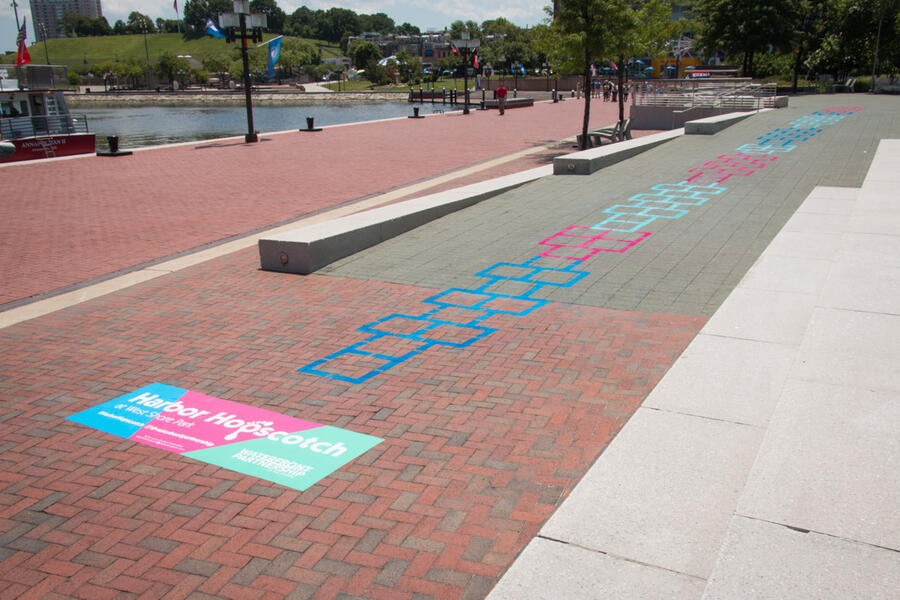
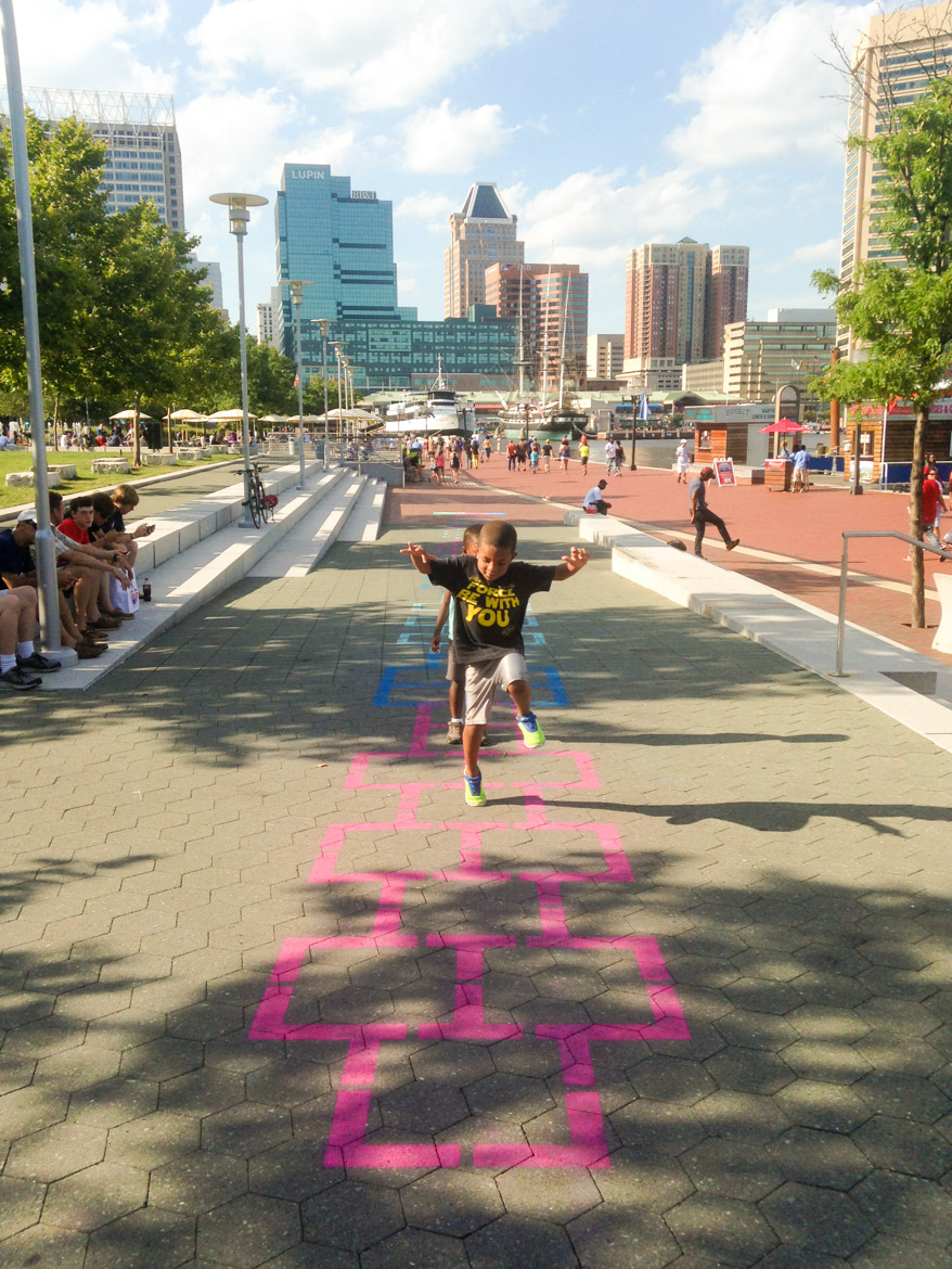
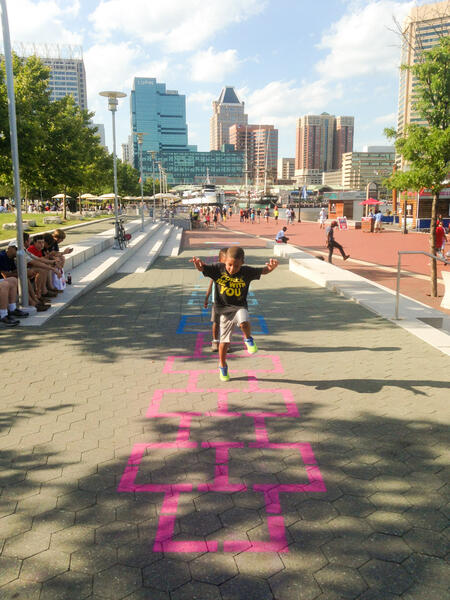 Harbor HopscotchHarbor Hopscotch is a 103’ long, colorful hopscotch court playfully activating the ramp entrance to West Shore Park at Baltimore’s Inner Harbor. The temporary installation of teal, electric blue, and fuchsia colored spray chalk was commissioned by the Waterfront Partnership of Baltimore to bring more people into the south end of this prominent public space. Pedestrians strolling on the Inner Harbor Promenade are met with a large project ground graphic inviting them to hop up the ramp leading into West Shore Park. The graphic also encourages participants to share pictures of each other jumping using the hashtag #HarborHopscotch and @waterfrontpartnership. Harbor Hopscotch West Shore Park, Inner Harbor, Baltimore, MD July 14, 2016
 -
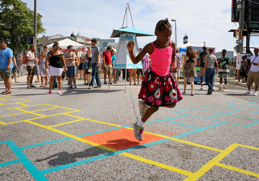 HopXcotch Rivalry Girl JumpingHopXcotch Rivalry in action. HopXcotch Rivalry was two extreme hopscotch courses crossing for one action packed, two person race. Inspired by the success of my Hopscotch Crosswalks in downtown Baltimore, this project brought playful pedestrian action to the middle of Artscape’s Field Day programing along Charles Street. Participants started at competing ends of the yellow and teal hopscotch paths had to jump fast while staying on track. The two 50’ long courses met at the middle, presenting an opportunity for racers to bump each other of course. The easy-to-understand and play game was enhanced with organized hopscotch tournaments at scheduled times throughout the Artscape weekend. Special thanks to the HopXcotch Rivalry tireless referees Melvin Thomas and Jake Lasovick. HopXcotch Rivalry July 18-20, 2014 Artscape N. Charles and Lanvale Streets Baltimore, MD
 -
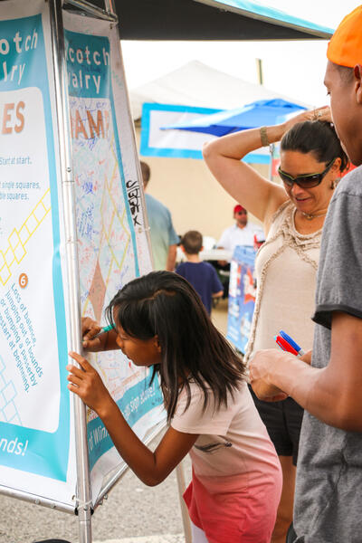 HopXcotch Rivalry - participant signing the wall of winnersHopXcotch Rivalry invted to sign the Wall of Winners HopXcotch Rivalry was two extreme hopscotch courses crossing for one action packed, two person race. Inspired by the success of my Hopscotch Crosswalks in downtown Baltimore, this project brought playful pedestrian action to the middle of Artscape’s Field Day programing along Charles Street. Participants started at competing ends of the yellow and teal hopscotch paths had to jump fast while staying on track. The two 50’ long courses met at the middle, presenting an opportunity for racers to bump each other of course. The easy-to-understand and play game was enhanced with organized hopscotch tournaments at scheduled times throughout the Artscape weekend. Special thanks to the HopXcotch Rivalry tireless referees Melvin Thomas and Jake Lasovick. HopXcotch Rivalry July 18-20, 2014 Artscape N. Charles and Lanvale Streets Baltimore, MD


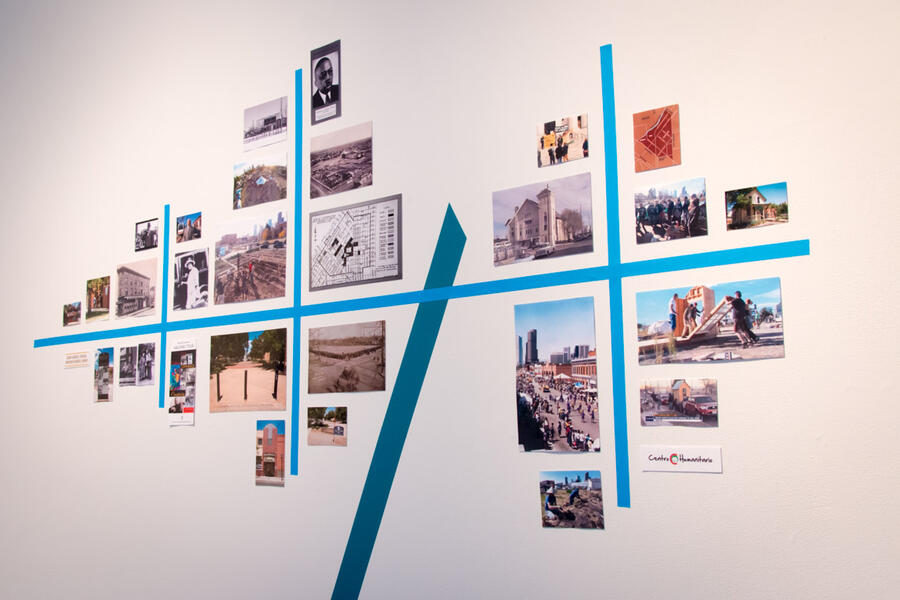
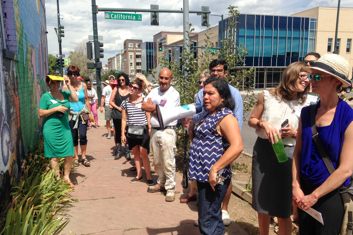
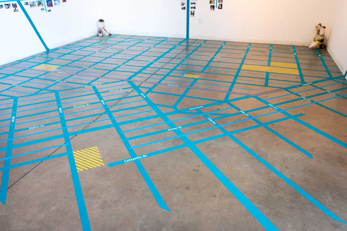
New Public Sites - Five Points Denver
-
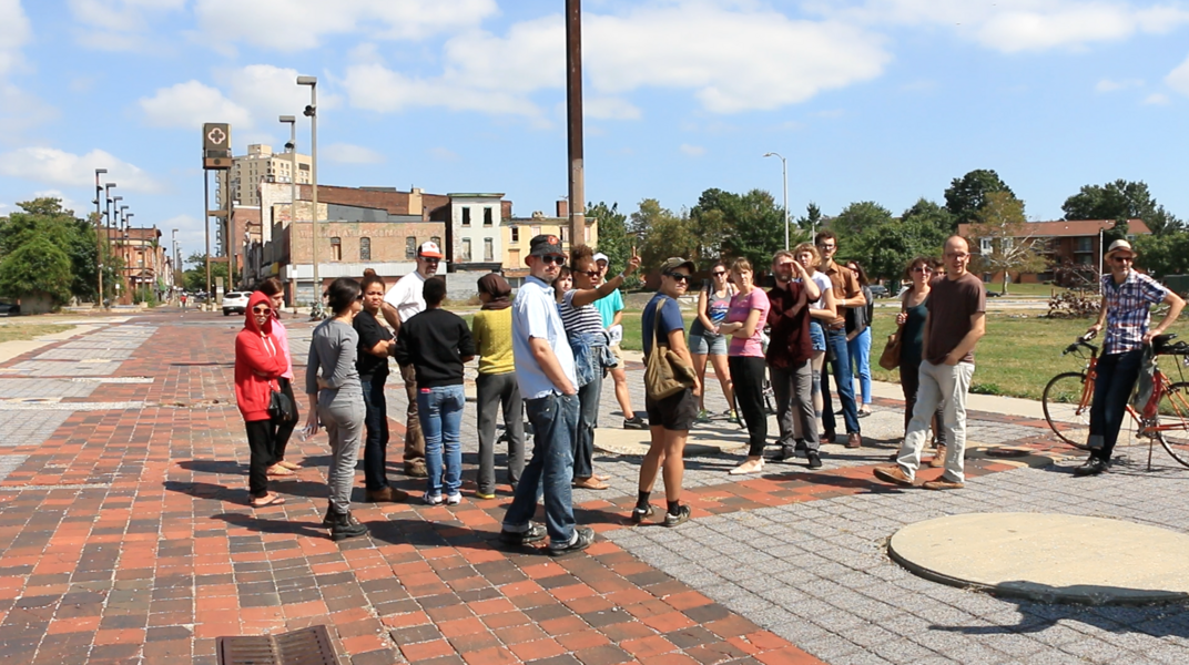
 NPS - Five Points Denver walking tour
 -
 NPS - Five Points Denver walking tour
 -
 NPS - Five Points Denver walking tour
 -
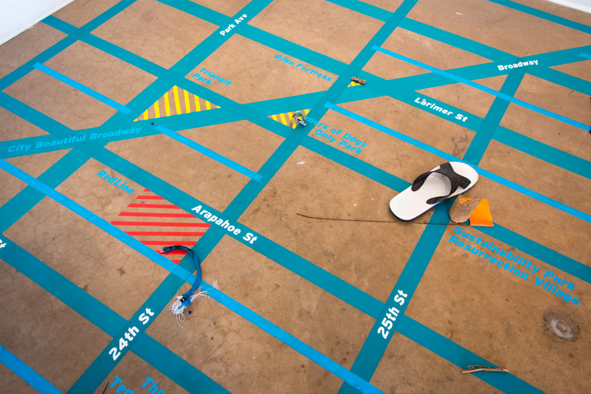
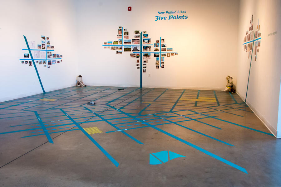 NPS - Five Points Denver immersive mapThe NPS - Five Point Denver immersive map installation showed how regular people have helped shape the history, design and current uses of public spaces around the Five Points and invited participants to contribute their own found objects from the area.
 -
 NPS - Five Point Denver immersive map
 -
 NPS - Five Point Denver immersive mapThe NPS - Five Point Denver immersive map installation showed how regular people have helped shape the history, design and current uses of public spaces around the Five Points and invited participants to contribute their own found objects from the area.
 -
 NPS - Five Point Denver immersive map


SiteLines Walking Tours, Video Series, & Gallery Installation
-
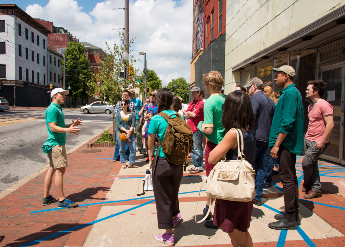
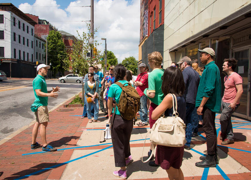 Wandering Shards of Specter Riches - Wakling TourIntroduction to walking tour exploring the histories of economic injustice embedded in the westside of downtown Baltimore. Wandering Shards of Specter Riches Meet at Current Space 421 N Howard St, Baltimore, Maryland 21201 May 9, 2015 Share Baltimore’s enduring strength as it struggles to survive top-down schemes of superblocked urban renewal. Wandering Shards of Spector Riches walking tour explores the specter riches of defensive architecture, Formstone facades and invisible sites of history and resistance. Share your own personal insights as we discover how capitalist speculation continues to harm the Westside while everyday people resist through small-scale entrepreneurialism, art and direct action.
 -
NPS SiteLines - Remote Sidewalk SublimeThe Urban Sublime An awesome and overpowering experience of place that allows comprehension of spatial enormity beyond ordinary sense and sight. Reservoir Chill Jones Falls Expressway at Druid Hill Park September 13, 2014 Where the sidewalk ends beyond a flowing overpass, climb as Druids towards a pastoral sublime. Reservoir Chill explores the overlapping embankments and sidewalks to nowhere between the Jones Falls Expressway and Druid Hill Park in Baltimore. The tour is free and open to the public. We will walk for approximately 60 minutes at a moderate pace. Voluntary physical activities including stepping over obstacles such as guard rails. Be prepared to climb a grassy hill.
-
 Old Town Mall re:authorized historiesTour participant sharing her history of Old Town Mall's height as one of Baltimore's major African American shopping districts. Video still
 -
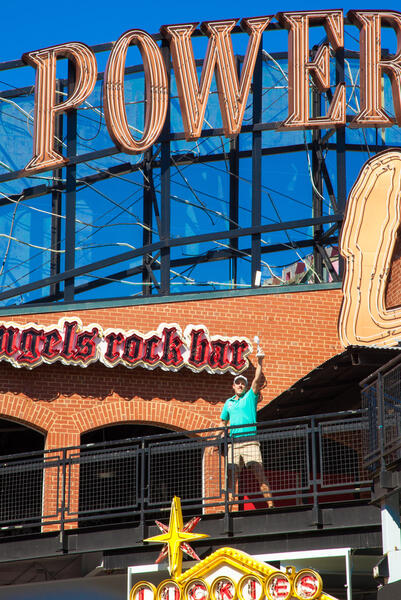 Power Plant Alive! Walking Tour - ClimaxHold the WIPA? Trophy aloft as we ascend the spectacle. Power Plant Alive! 601 E Pratt St, Baltimore, MD 21201 at the south side of Market Place and Pratt St. September 27, 2014 Wear your full rock gear to swamp the market and flip the switch on its power of place. Power Plant Alive! explores the Sub/urban Ambiguity of the Cordish Companies ground-breaking, pseudo urban spectacle complex in downtown Baltimore. Including Empty Signifiers, a Monument to Elevated Terror and the ever-present Urban Sublime, among many other invisible public spaces, this tour showcases the complexities of what Baltimore presents as “urban entertainment” to regional and out-of-town visitors.
 -
NPS SiteLines - High Path Low RoadHigh Path Low Road Reservoir Chill Jones Falls Expressway at Druid Hill Park September 13, 2014 Where the sidewalk ends beyond a flowing overpass, climb as Druids towards a pastoral sublime. Reservoir Chill explores the overlapping embankments and sidewalks to nowhere between the Jones Falls Expressway and Druid Hill Park in Baltimore. The tour is free and open to the public. We will walk for approximately 60 minutes at a moderate pace. Voluntary physical activities including stepping over obstacles such as guard rails. Be prepared to climb a grassy hill.
-
 Power Plant Alive! Exploring Aural UncertaintyParticipants listening to a Box of Uncertainty along the Power Plant Alive! tour while the tour guide narratives remotely via walkie talkie. Box of Uncertainty: A box of harmonious form and demeanor, ever so quiety undone by subtleties of sound and/or entropy. Photo by James Singewald.
 -
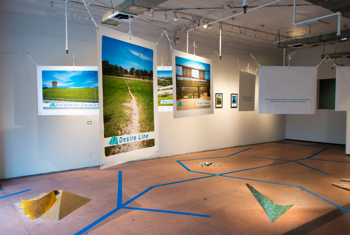
 SiteLines gallery installation at Current SpaceInstallation featuring hanging pigmented ink banners, framed photos, and found material sculptures - all derived from explorations of invisible public sites. On their fronts, these banners feature photos of memorable SiteLines places, while on their reverse sides the banners display poetic definitions inspired by the architecture and alternative histories of Baltimore. SitesLines ICA Baltimore at Current Space 421 North Howard Street, Baltimore, MD 21201 Baltimore, MD SiteLines was a multimedia collection of online videos, experimental walking tours and an immersive art installation presented by ICA Baltimore at Current Space, featuring banners, photography, typography and cartography derived from nearby invisible public spaces. Sitelines is a translation of New Public Sites walking tours into video web series capturing the artist and walking tour participants as they playfully explore public space while he shares the sites’ histories, design, and uses. The ongoing New Public Sites project interprets the overlooked and invisible sites within cities, investigates the negotiable nature of public space, and pushes the boundaries of pedestrian agency. Filming for the first season of SiteLines began in September 2014 with four tours: Crossing the Highway to Nowhere, Reservoir Chill, Old Town Walking Revival and Power Plant Alive! These collections of new public sites are connected by suburban style development in an urban context, including freeways and pedestrian malls. Videos from these walks will be incorporated into a larger installation of banners, photography, typography, found object sculptures and a gallery-size map at Baltimore’s Current Space.
 -
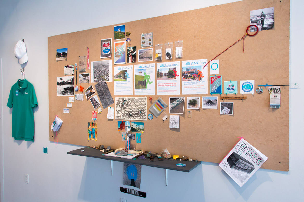
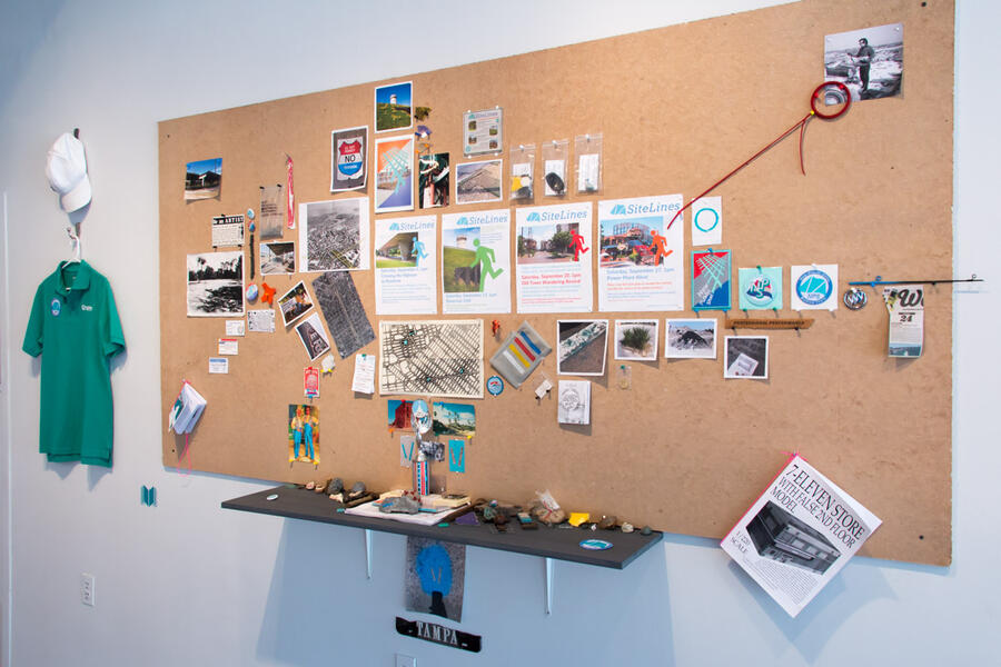 SiteLines - New Public Bulletin BoardBulletin board installation featuring ephemera, research, and found objects derived from walking tours of invisible sites. SitesLines ICA Baltimore at Current Space 421 North Howard Street, Baltimore, MD 21201 Baltimore, MD SiteLines was a multimedia collection of online videos, experimental walking tours and an immersive art installation presented by ICA Baltimore at Current Space, featuring banners, photography, typography and cartography derived from nearby invisible public spaces. Sitelines is a translation of New Public Sites walking tours into video web series capturing the artist and walking tour participants as they playfully explore public space while he shares the sites’ histories, design, and uses. The ongoing New Public Sites project interprets the overlooked and invisible sites within cities, investigates the negotiable nature of public space, and pushes the boundaries of pedestrian agency. Filming for the first season of SiteLines began in September 2014 with four tours: Crossing the Highway to Nowhere, Reservoir Chill, Old Town Walking Revival and Power Plant Alive! These collections of new public sites are connected by suburban style development in an urban context, including freeways and pedestrian malls. Videos from these walks will be incorporated into a larger installation of banners, photography, typography, found object sculptures and a gallery-size map at Baltimore’s Current Space.
 -
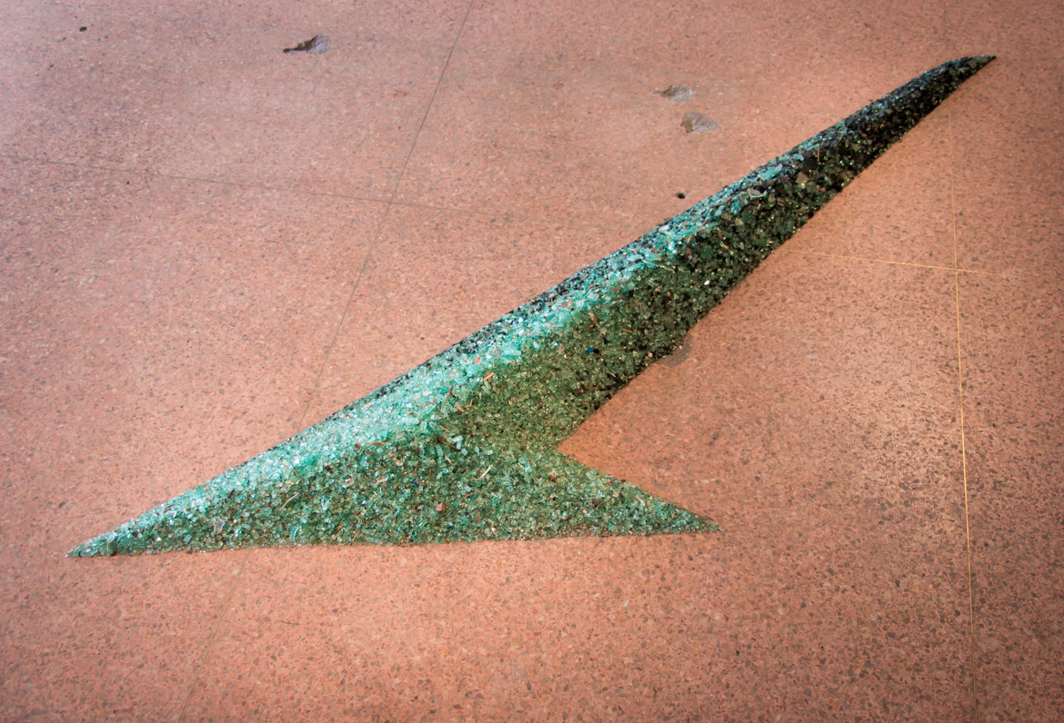
 SitesLines - Shattered ShieldsShattered Shields sculpture This sculpture is made from shattered safety glass of car windshields collected from nearby streets in Baltimore. The glass is arranged into an arrow, pointing participants towards a reclaimed future of pedestrian prosperity. SitesLines ICA Baltimore at Current Space 421 North Howard Street, Baltimore, MD 21201 Baltimore, MD SiteLines was a multimedia collection of online videos, experimental walking tours and an immersive art installation presented by ICA Baltimore at Current Space, featuring banners, photography, typography and cartography derived from nearby invisible public spaces. Sitelines is a translation of New Public Sites walking tours into video web series capturing the artist and walking tour participants as they playfully explore public space while he shares the sites’ histories, design, and uses. The ongoing New Public Sites project interprets the overlooked and invisible sites within cities, investigates the negotiable nature of public space, and pushes the boundaries of pedestrian agency. Filming for the first season of SiteLines began in September 2014 with four tours: Crossing the Highway to Nowhere, Reservoir Chill, Old Town Walking Revival and Power Plant Alive! These collections of new public sites are connected by suburban style development in an urban context, including freeways and pedestrian malls. Videos from these walks will be incorporated into a larger installation of banners, photography, typography, found object sculptures and a gallery-size map at Baltimore’s Current Space.
 -
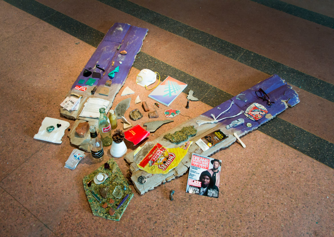
 SiteLines - Shards of SiteShards of Site - Shredded pavement souvenirs serving as mementos of place. These shards of site were collected by participants along two walking tours: Crossing the Highway to Nowhere and Wandering Shards of Specter Riches. SitesLines ICA Baltimore at Current Space 421 North Howard Street, Baltimore, MD 21201 Baltimore, MD SiteLines was a multimedia collection of online videos, experimental walking tours and an immersive art installation presented by ICA Baltimore at Current Space, featuring banners, photography, typography and cartography derived from nearby invisible public spaces. Sitelines is a translation of New Public Sites walking tours into video web series capturing the artist and walking tour participants as they playfully explore public space while he shares the sites’ histories, design, and uses. The ongoing New Public Sites project interprets the overlooked and invisible sites within cities, investigates the negotiable nature of public space, and pushes the boundaries of pedestrian agency. Filming for the first season of SiteLines began in September 2014 with four tours: Crossing the Highway to Nowhere, Reservoir Chill, Old Town Walking Revival and Power Plant Alive! These collections of new public sites are connected by suburban style development in an urban context, including freeways and pedestrian malls. Videos from these walks will be incorporated into a larger installation of banners, photography, typography, found object sculptures and a gallery-size map at Baltimore’s Current Space.


New Public Maps, Prints & Signs
-
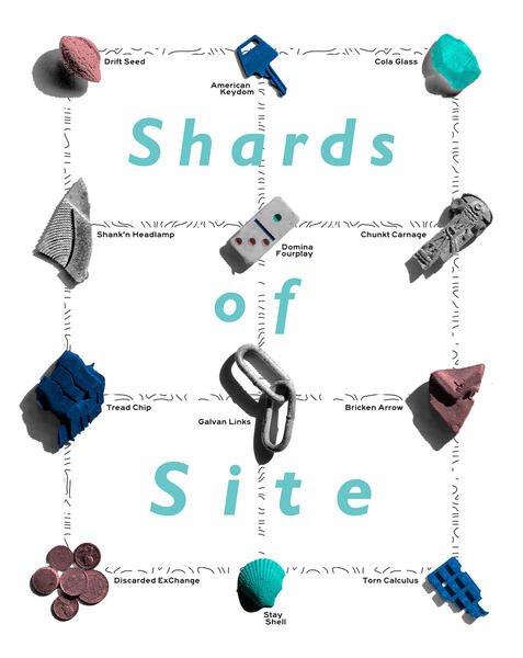 Shards of Site PrintThe Shards of Site was created for the inaugural Print/Collect portfolio features an array of poetically titled urban artifacts collected from the streets of Baltimore. The shredded pavement souvenirs will serve as mementos of place as they gracefully hang on the walls of your urban abode. The print is a 20” x 16” pigmented ink print on archival 13.5mil cotton rag. Limited edition of 125 signed and numbered.
 -
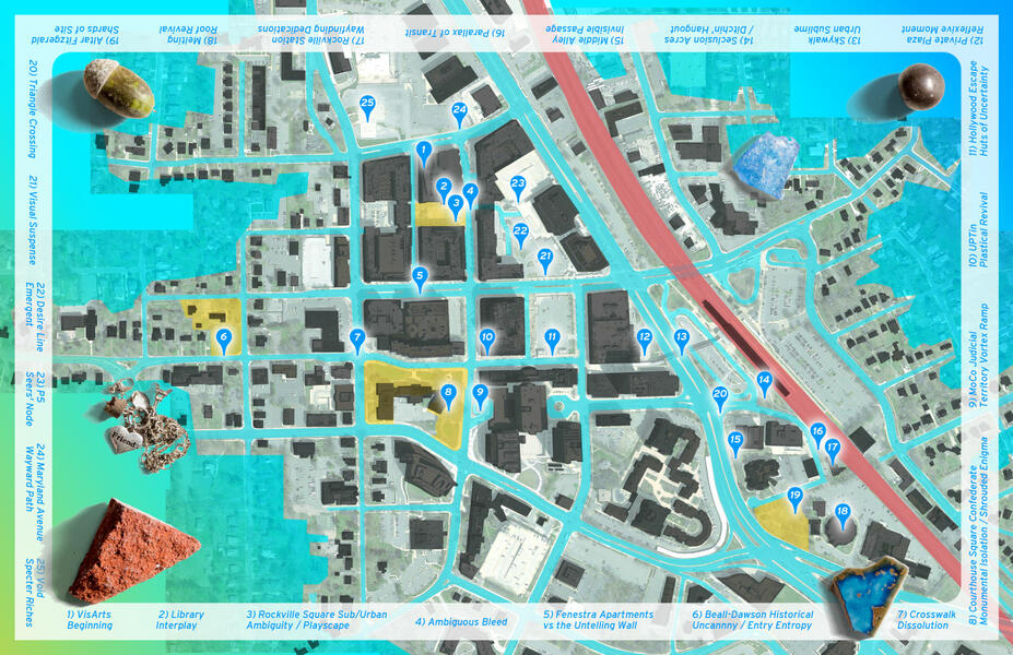 NPS - The Ragged Edge of Rockville - Walking Tour - Free MapFree, foldable map locating, naming and defining the many new public sites around downtown Rockville.
 -
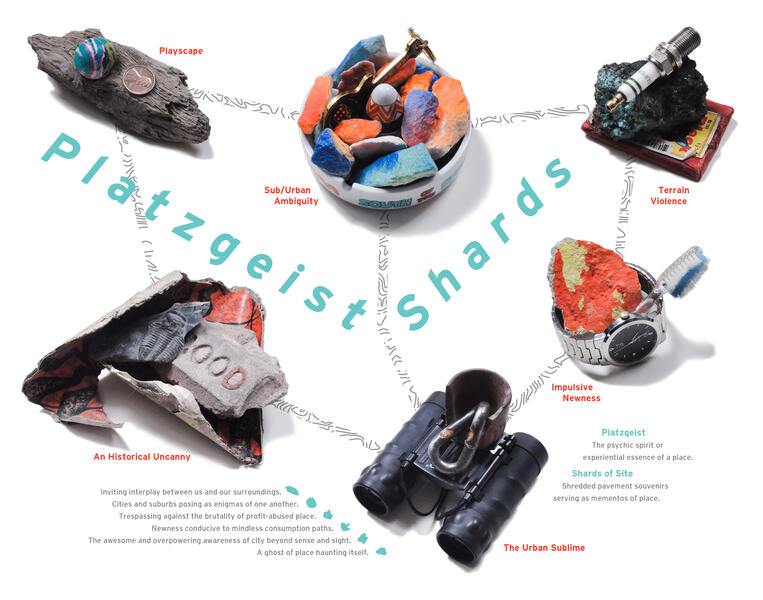 Platzgeist ShardsThe Platzgeist Shards poster presents an array of found and appropriated objects symbolically arranged to convey specific ‘spirits of place’. As individual Shards of Site, each object is a souvenir serving as mementos of place. Hypergraphically assembled, these shards are an attempt to capture the psychic or experiential essences of specific types of place. As a map or non-site, the Platzgeists Shards poster also identifies and defines the corresponding terms and ideas listed below. The print is an 11” x 14” pigmented ink print on archival paper. Limited edition of 10, signed and numbered. This print was first released at the 5th Annual Open Space Prints and Multiples Fairs in Baltimore, Maryland. Special thanks for Liz Donadio of Color Wheel Digital Printing for making this print possible. Platzgeist The psychic spirit or experiential essence of a place. Shards of Site Shredded pavement souvenirs serving as mementos of place. Impulsive Newness Newness conducive to mindless consumption paths. An Historical Uncanny A ghost of place haunting itself. Terrain Violence Trespassing against the brutality of profit-abused place. Sub/Urban Ambiguity Cities and suburbs posing as enigmas of one another. The Urban Sublime An awesome and overpowering awareness of city beyond sense and sight. Playscape Inviting interplay between us and our surroundings.
 -
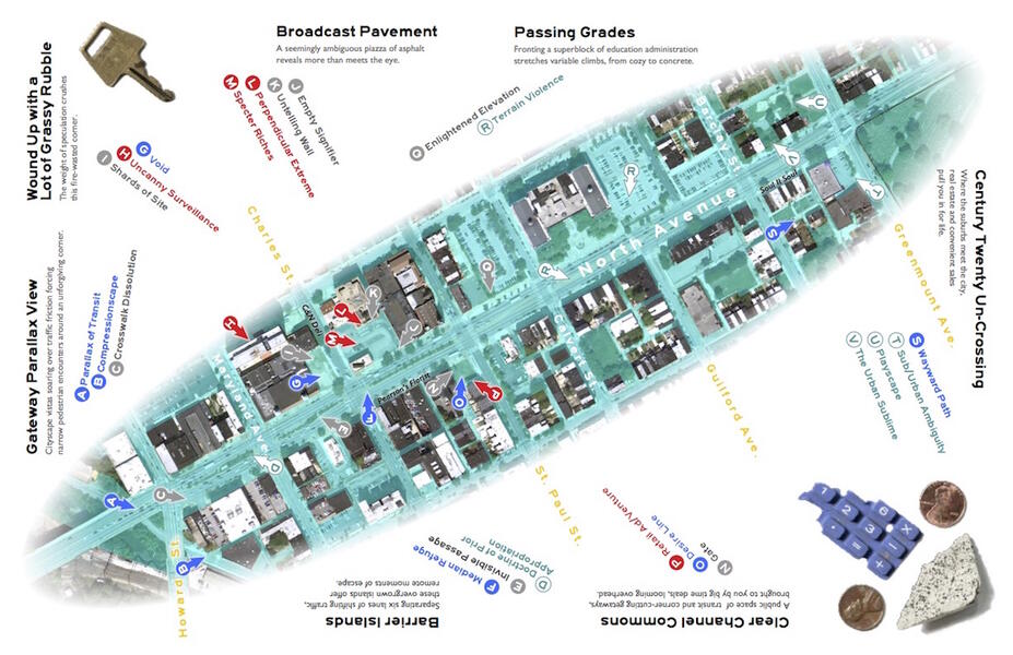 New Public Sites – Station North Avenue Free MapOrganized in conjunction with Invited: Celebration Station October 21 – November 11, 2012. MICA Graduate Studio Center Sheila & Richard Riggs and Leidy galleries 113 W. North Avenue, Baltimore, MD 21201 Google map New Public Sites – Station North Avenue (NPS-SNA) is free walking tour through seven collections of invisible sites and overlooked architectural and psychic features along North Avenue between Greenmount and Howard Streets. The New Public Sites – Station North Avenue project invites a practice of “radical pedestrianism” that pushes urbanite agency, interprets the overlooked and banal and investigates the negotiable nature of the built environment. These psychogeographic tours began at Station North’s northeastern, parallax gateway and continued towards the district’s northwestern sub/urbanely ambiguous crossing. Along the way, the tours featured places such as a billboard-framed vacant lot identified as “Clear Channel Commons”, North Avenue’s impressive median strip, which is likened to “Barrier Islands”, plus a selection of Anniversary List businesses. The New Public Sites Kiosk provided information on the project and offered a bulletin board for local events while serving as a meeting point for tour participants. Free NPS-SNA maps for self-guided tours were also available in the gallery. Celebrating the 10th anniversary of Station North Arts & Entertainment District, Invited was a two-part exhibition: a series of site-specific artworks in 10 area businesses as well as a community inspired and celebratory-themed gallery show in MICA’s newly renovated Graduate Studio Center Sheila & Richard Riggs Gallery. The Invited show was organized by MICA’s M.F.A. in Curatorial Practice program with support from support of MICA’s Office of Community Engagement, Station North Arts & Entertainment, Inc., and Friends of Curatorial Practice.
 -
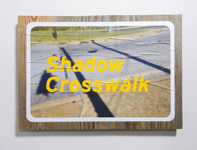 Shadow CrosswalkNew Public Sites – Road Signs are “poster-paintings” consisting of photographs appropriated from the New Public Sites tumblr enlarged and printed on 20lb bond paper, wheat pasted on found plywood, then accented with hand-painted terms and ideas from the New Public Sites Typology. 14? x 20?, Pigmented ink print, plywood, wheat paste, acrylic paint. First exhibited with print/collect at the (e)merge art fair October 4-6, 2013.
 -
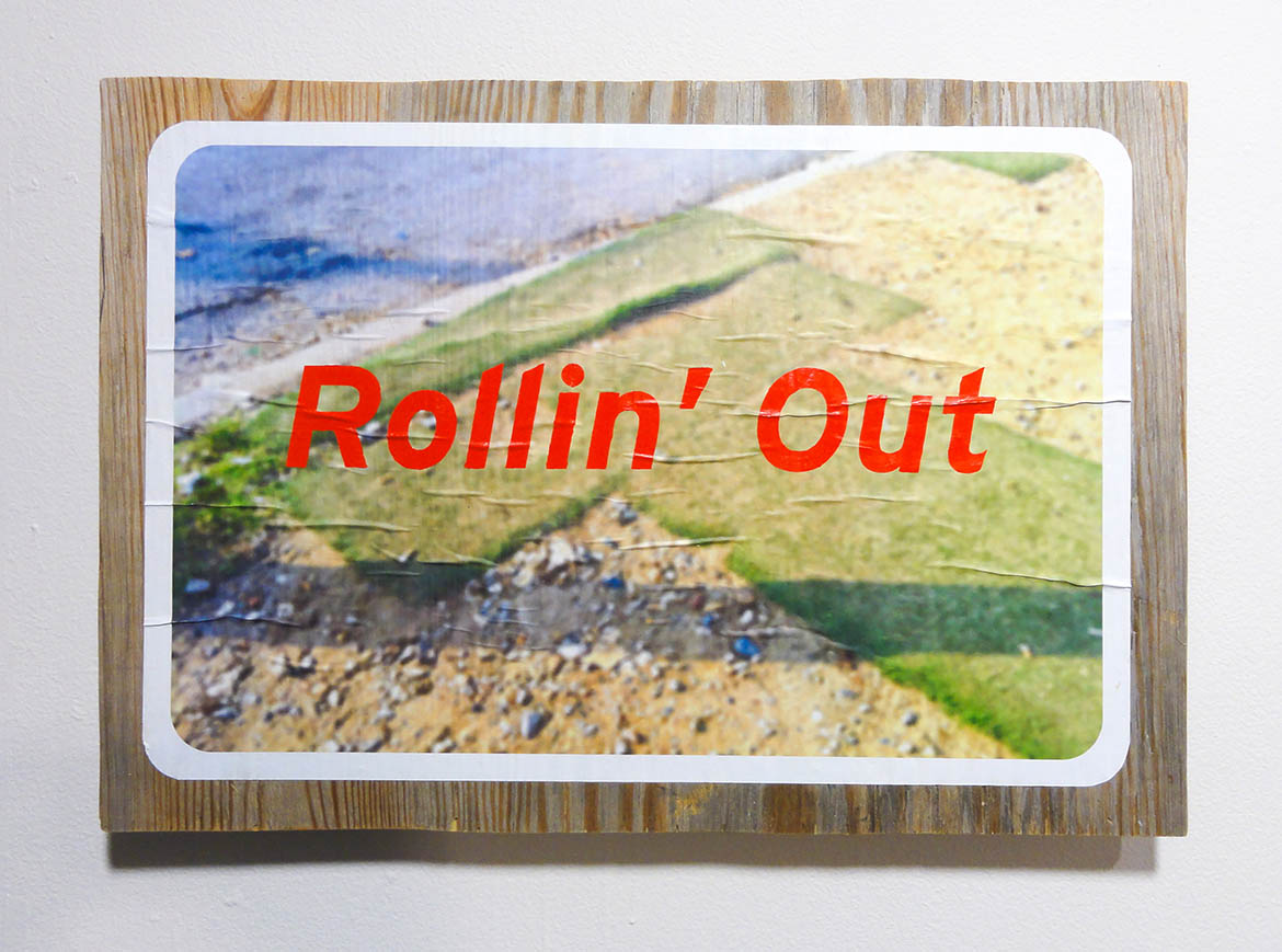
 Rollin' OutNew Public Sites – Road Signs are “poster-paintings” consisting of photographs appropriated from the New Public Sites tumblr enlarged and printed on 20lb bond paper, wheat pasted on found plywood, then accented with hand-painted terms and ideas from the New Public Sites Typology. 14? x 20?, Pigmented ink print, plywood, wheat paste, acrylic paint. First exhibited with print/collect at the (e)merge art fair October 4-6, 2013.
 -
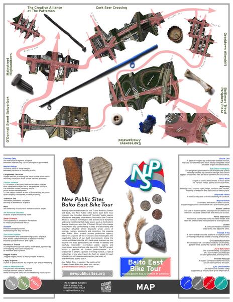 New Public Sites – Balto East Bike TourSaturday, October 5th, 2013 1-2:30 p.m. the Creative Alliance 3134 Eastern Ave., Baltimore MD 21224 Travel Eastern Ave, O’Donnell St America! Take a self/guided bicycle tour from Highlandtown to the Travel America Center and back, that will explore how the urban design of “invisible” public spaces affect our everyday experiences of eastern Baltimore. The tour will investigate the architectural dynamics and social conditions that make places such as the Eastern Avenue Underpass and the O’Donnell Street Interchange as mundane and confounding as they are fascinating and beautiful. A version of this tour was featured on the podcast 99% Invisible. Bring your bicycle, helmet & radical pedestrianism! The first Balto East Bike Tour took place on October 5, 2013 and was hosted by the Creative Alliance. Click here for blog post recap of the event and here for additional photos on flickr. Download the map below for a self-guided tour or sign up for the mailing list using the “contact” button above to receive alerts on the next time this tour is offered.
 -
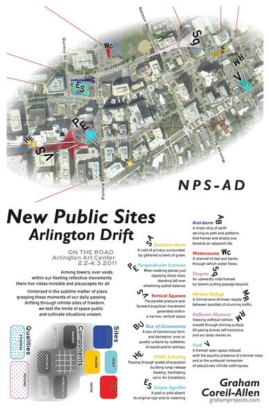 New Public Sites - Arlington Drift Free MapON THE ROAD Arlington Art Center 3550 Wilson Blvd + Ballston neighborhood Arlington, VA February 2 - April 3, 2011 Curated by Jeffry Cudlin Among towers, over voids, within our fleeting reflective movements there live vistas invisible and playscapes for all. Immersed in the sublime matter of place, grasping these moments of our daily passing, drifting through infinite sites of freedom, we test the limits of space public and cultivate situations unseen. New Public Sites - Arlington Drift was a combination video/cartography installation and radical pedestrian walking tour that investigated some of the invisible sites and liminal zones within Arlington's Ballston neighborhood. Dating back to the 19th century, the Ballston neighborhood lies due west of the Washington DC mall, across the Potomac River. After the opening of the Ballston Metrorail station in 1979, the neighborhood began to go through successive waves of redevelopment and densification that resulted in what it is today - a collection of low-density suburban buildings and detached homes mixed with tall modern office buildings, including many government agencies, private companies and non-profits, apartment complexes and condominiums, the Ballston Common Mall, and many restaurants and bars.
 -
 New Public Sites - Middle Branch Crossing Free MapMiddle Branch of the Patapsco River + Maryland Institute College of Art M.F.A. Thesis Exhibition III Meyerhoff Gallery 1300 W. Mount Royal Ave. Baltimore, MD 21217 April 23 - May 2, 2010 Beyond a raven stadium and above the Westport light rail station lies a majestic collection of public spaces around the northwestern tip of the Patapsco River's Middle Branch. Here a transit network spans a waterfront amalgam of voids, lost spaces, paths, pauses and vistas. Traversed by floating zones and directional flow, this spectacular gateway to Baltimore reveals a shimmering parallax of invisible sites. During NPS-MBX, participants were invited to explore the Middle Branch Crossing through three free tours: car, bicycle and light rail.
 -
 New Public Sites - Middle Branch Crossing Wall MapMiddle Branch of the Patapsco River + Maryland Institute College of Art M.F.A. Thesis Exhibition III Meyerhoff Gallery 1300 W. Mount Royal Ave. Baltimore, MD 21217 April 23 - May 2, 2010 Beyond a raven stadium and above the Westport light rail station lies a majestic collection of public spaces around the northwestern tip of the Patapsco River's Middle Branch. Here a transit network spans a waterfront amalgam of voids, lost spaces, paths, pauses and vistas. Traversed by floating zones and directional flow, this spectacular gateway to Baltimore reveals a shimmering parallax of invisible sites. During NPS-MBX, participants were invited to explore the Middle Branch Crossing through three free tours: car, bicycle and light rail.